12

Here is what I have:

ArcGIS Desktop Advanced (10.2) & MS SQL Server 2008 R2

Here is my problem:

I need to be able to connect to the ms sql server and import, export, create, and edit spatial data. I can connect to my database and export features to it using the "Feature Class to Geodatabase" tool but can't edit the data once bringing it back into an ArcMap session. I have tried using the "Create Enterprise Geodatabase" tool available with the advanced desktop license but it asks for an Authorization File (for ArcGIS for Server I assume) that I don't have. I have looked at prices for ArcGIS for Server and it is not feasible option.

Are there alternatives to achieve what I need to using what I currently have licenses for?

Where does arcSDE fit into this?

3
  • 1
    Are you planning for multi-user editing or require versioning? If not and its just a spatial data store why not simply use a File Geodatabase? Your question will be better answered if you say what you intend to with it as that dictates the limitations of the various storage formats.
    – Hornbydd
    Commented Sep 30, 2014 at 15:43
  • I have been in a similar situation. You might try exporting using 'Feature class to geodatabase', then open the exported data with QGIS (free). Then edit to your hearts content using QGIS, while still on the server. The bonus here is that even if Arc can't edit your resulting table, it can still do most things you would do with a table made otherwise. I'm willing to bet he wants to keep his data on a server due to processes we aren't privy to here.
    – ike
    Commented Sep 30, 2014 at 21:42
  • You can try st-links spatialKit: www.st-links.com
    – user50781
    Commented Apr 20, 2015 at 15:09

2 Answers 2

9

To be able to work with a geodatabase stored in SQL Server you would need at least ArcGIS Server Basic Workgroup (see matrix here). You can work with simple features in ArcMap, but no geodatabase editing or alike will be available.

Since you have ArcGIS Desktop (I assume you have Standard or Advanced), you get automatically access to geodatabase stored within SQL Server Express (referred to as database server).

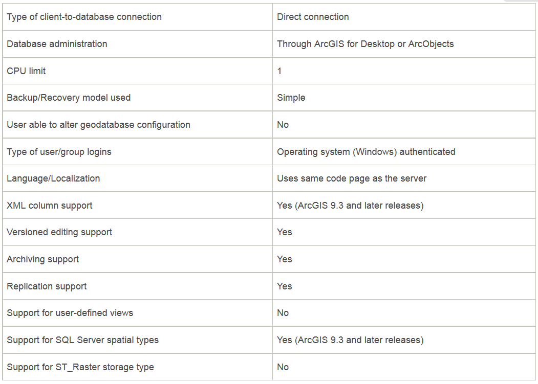
It might be a good start if buying ArcGIS Server is not a feasible option. This is what you get with database server in ArcGIS Desktop (applies to ArcGIS for Desktop Standard and ArcGIS for Desktop Advanced only). You will be limited though:

only 3 simultaneous connections can be established (including ArcGIS Server services if you will have any later on), the max size of the geodatabase is 10GB, and there are other SQL Server Express (non-Esri) related limitations on hardware.

enter image description here

You get access to SQL Server Express either on your own or through Esri Customer Care Portal (access with your customer account). There is a detailed tutorial on that here.

I suggest you to get started with the database server first and see whether it suits your needs with some workarounds here and there.

2
  • Yes, your 2nd paragraph contradicts your 1st. You can work with data in SQL Server without ArcGIS Server by using the "database server". It is very limited and can feel very constraining, but is a great environment to learn on before going all in and buying server. You can learn how to do a lot of spatial tasks without touching ArcServer using SQL Spatial operations.
    – JasonT
    Commented Apr 20, 2015 at 23:01
  • @JasonT, you cannot access SQL Server without having ArcGIS Server to edit the data. You can use SQL Server Express though (this is not full featured SQL Server) if you have ArcGIS Desktop Standard+ to work with a database server. I've supplied an alternative in the 2nd paragraph in case it is relevant for the person who asks. There is no contradiction here :) Commented Apr 21, 2015 at 5:52
7

No, you do not need ArcGIS Server to edit your MS SQL Server database. If you want to continue to interface with ArcMap/ArcCatalog without a ArcGIS Server license you do have at least one other (albeit non-free, but definitely cheaper than an ArcGIS Server License) option.

I need to be able to connect to the ms sql server and import, export, create, and edit spatial data... Are there alternatives to achieve what I need to using what I currently have licenses for?

You can load data into SQL Server 2008 using SQL Server Spatial Tools. For exporting, creating and editing spatial data using your current license level you should have a look at GISquirrel.

From the website:

GISquirrel is an extension to ESRI's ArcGIS Geographical Information System that turns into an editing client for Microsoft SQL Server or PostGreSQL/PostGIS without the need for additional middleware or higher licence levels. GISquirrel provides new ways of integrating spatial data with wider information management systems.

A quick browsing of the FAQ says you can use it to both load and export data. The obvious limitations of the program that are stated on the website are as follows:

  • Does not support raster data
  • Does not support vector data with M or Z values

A license currently costs £150.00 (about US $245). If you are a nonprofit you may be eligible for a free license.

Where does arcSDE fit into this?

ArcSDE acts as an interpreter/organizer of the spatial data stored in SQL Server. It provides a bridge for your data to interface with ESRI's products. The program above acts as an "ArcSDE Lite" in a way with very basic functionality.

As a final note: If you aren't married to the ESRI platform you can also edit MSSQL data through QGIS.

Your Answer

By clicking “Post Your Answer”, you agree to our terms of service and acknowledge you have read our privacy policy.

Not the answer you're looking for? Browse other questions tagged or ask your own question.