8

I'm looking for a shapefile containing an 1000m or 2000m UTM grid ("graticule"). All I was about to find on the web is a 10000m UTM grid (here: http://en.giswiki.net/wiki/UTM) and I am aware that a 1000m UTM grid for the whole world might be quite big.

That's why I'm now wondering if and how it would be possible to generate such a shapefile for a part of the world. I would prefer to use open source tools like gdal. Others output formats than a shapefile might be ok too.

Has anyone an idea?

3 Answers 3

4

Thanks to the other answers I was able to do it this way:

  1. Determine the wanted UTM coordinates.

    • UTM zone: determine the zone between 1 and 60 by looking at a map like here http://en.wikipedia.org/wiki/Universal_Transverse_Mercator_coordinate_system
    • EPSG code for the UTM zone: on WGS84 it is EPSG:326xx, where xx is the number of the zone (see http://www.spatialreference.org/ref/?page=18&search=UTM+zone). In Europe some maps use ETRS89 instead of WGS84. There is also a corresponding EPSG code (EPSG:258xx) but the difference to WGS84 is too small to notice, so that you can as well use WGS84.
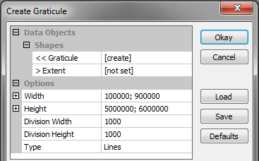
    • Easting: within a zone the easting coordinate is always greater than 100000m and smaller than 900000m, so I simply take 100000-900000 as limits for the easting value.
    • Northing: it's the distance to the equator, let's say I need a 1000km part between 5000000m and 6000000m.
  2. Use SAGA GIS as suggested by johanvdw. Start a new project, select MODULES-SHAPES/TOOLS > CREATE GRATICULE, enter the following values and click “Okay”:enter image description here

    (It might alternatively be possible to use QGIS as suggested by Darren Cope)

  3. Go to the tab “Data”, right click on the graticule in the tree and choose “Save as” to create a shapefile. Let's say “UTM_without_CS.shp”.

  4. Use ogr2ogr to attribute a coordinate system. Let's say you want UTM zone 30 on WGS 84 (= EPSG:32630):

    ogr2ogr -a_srs EPSG:32630 UTM.shp UTM_without_CS.shp

That's it!

3

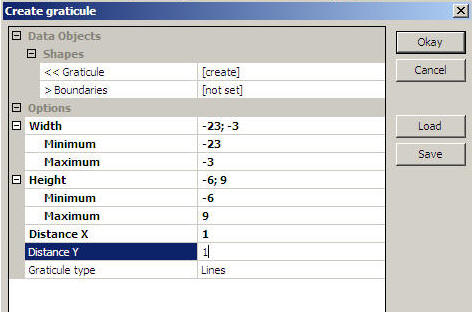
You can also do this in SAGA GIS, A full explanation can be found here: http://marinedataliteracy.org/margis/grats_frames.htm

enter image description here

2
  • Thanks. I hadn't heard from SAGA GIS before. I have just made a quick try. I was at least able to generate a simple graticule. I haven't yet found if it is possible to select UTM coordinates, but I will try again another day. It seems promising.
    – Name
    Commented Jun 4, 2012 at 20:40
  • Thanks again, it's working! I've simply generated a graticule with 1000m as distance on X and Y and export it as shapefile. Then I've assigned the coordinate system of the corresponding UTM zone to the shapefile using ogr2ogr (for example EPSG:32601 for zone 01 with WGS 84 as ellipsoid) and I have exactly what I need. I will try to make a step by step description later.
    – Name
    Commented Jun 16, 2012 at 14:37
2

QGIS has a 'Vector Grid' tool (under Vector > Research Tools) that you can give extents and grid size. Sounds like it will do exactly what you want.

4
  • Thanks. When I try it, QGIS freezes and I don't get anything. I might try again later if I have more chance.
    – Name
    Commented Jun 4, 2012 at 20:36
  • Name; if are actually trying to generate a 1kmx1km grid for a large area, it's possible you are hitting the shapefile size limitation. Did you try a smaller area as a test? Also, make sure you have upgraded to the latest version of QGIS as well. Commented Jun 5, 2012 at 11:41
  • I tried with QGIS 1.6.0. I will download the current version 1.7.4 and try again. But in the window I could only enter the min and max value and no distance between the lines, so I doubt it will work for my purposes as I need 1000 or 2000m as grid distance.
    – Name
    Commented Jun 16, 2012 at 14:54
  • It actually worked with version 1.7.4 by entering 1000 as parameter (But it's buggy because after entering 1000 it displayed a much bigger value). What surprised me it that the resulting shapefile is much smaller that with SAGA GIS (less than 500KB against 50MB for a 800x1000km area...)
    – Name
    Commented Jun 16, 2012 at 15:34

Your Answer

By clicking “Post Your Answer”, you agree to our terms of service and acknowledge you have read our privacy policy.

Not the answer you're looking for? Browse other questions tagged or ask your own question.