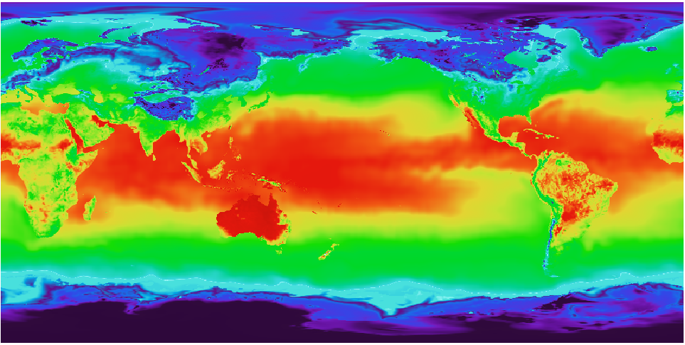
I have a geotiff raster image that has a coordinate system with longitudes from 0 to 360. The horizontal center of the image is 180 longitude. See image below:

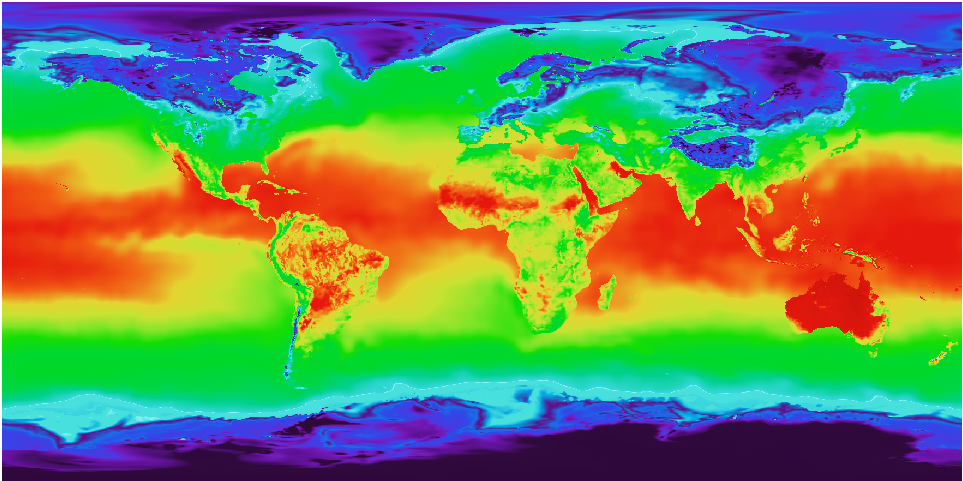
I want to transform it to EPSG:4326 SRS with -180 180 longtitude range. And I want the center of the image to be at Greenwich meridian (0). I guess this srs is very widely used. I expect the result look like this:

So I use a gdalwarp command to reproject:
gdalwarp -s_srs '+proj=latlong +datum=WGS84 +pm=180dW' -t_srs EPSG:4326 test_col.tif test_4326.tif
But I only get a tiff with bigger dimensions (more pixels) and EPSG:4326 metadata. The image itself looks the same, as the initial one. But I expect it to swap the hemispheres.
How do I gdalwarp an image to be strictly -180 180 EPSG:4326 with the center in 0 longitude?
This is gdalinfo of my initial file:
Origin = (-0.102272598067084,89.946211604095552)
Pixel Size = (0.204545196134167,-0.204423208191126)
Metadata:
  AREA_OR_POINT=Area
Image Structure Metadata:
  INTERLEAVE=BAND
Corner Coordinates:
Upper Left  (  -0.1022726,  89.9462116) (  0d 6' 8.18"W, 89d56'46.36"N)
Lower Left  (  -0.1022726, -89.9462116) (  0d 6' 8.18"W, 89d56'46.36"S)
Upper Right (     359.897,      89.946) (359d53'50.18"E, 89d56'46.36"N)
Lower Right (     359.897,     -89.946) (359d53'50.18"E, 89d56'46.36"S)
Center      ( 179.8975000,  -0.0000000) (179d53'51.00"E,  0d 0' 0.00"S)
This is gdalinfo after gdalwarp
Origin = (-180.102727401932952,89.946211604095552)
Pixel Size = (0.091397622896436,-0.091420837939082)
Metadata:
  AREA_OR_POINT=Area
Image Structure Metadata:
  INTERLEAVE=PIXEL
Corner Coordinates:
Upper Left  (-180.1027274,  89.9462116) (180d 6' 9.82"W, 89d56'46.36"N)
Lower Left  (-180.1027274, -89.9699975) (180d 6' 9.82"W, 89d58'11.99"S)
Upper Right ( 179.8211116,  89.9462116) (179d49'16.00"E, 89d56'46.36"N)
Lower Right ( 179.8211116, -89.9699975) (179d49'16.00"E, 89d58'11.99"S)
Center      (  -0.1408079,  -0.0118929) (  0d 8'26.91"W,  0d 0'42.81"S)
