2

I have a shapefile with a series of points (around 300) using British National Grid. I need to put them on my Garmin Etrex 10 as waypoints.

Can someone tell me how to convert this shapefile into GPX data?

It may also be helpful to know how to make this into a route. The points are named 1 to 300 and would be visited in that order.

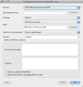
This is what I get up when saving as… what field names must I use? s

3 Answers 3

3

Choose "Save as" -> "GPS eXchange Format (GPX)":

enter image description here

1
2

Some applications like the excellent GPS Utility make shapefile-GPX conversions very straightforward, allowing you to identify what the waypoint name field is directly, and to do a lot of editing (often needed for field navigation). The ability to down/upload to a variety of GPS models is also valuable (I have yet to have consistent success with QGIS for interacting with a GPS).

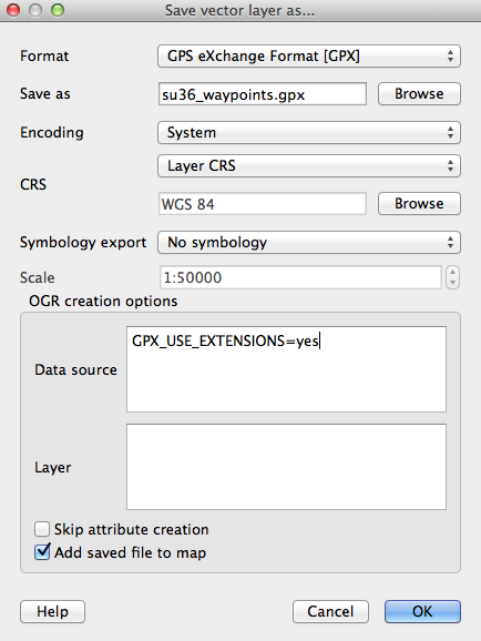
For a QGIS solution to create waypoints and routes, you need a point layer for your waypoints, and a line layer for the route, both with a 'name' field. The 'name' field will carry through to the GPX file (and thus GPS) as the waypoint ID and the route name. Use the GPX_USE_EXTENSIONS=yes option to avoid the error you were seeing:

enter image description here

Tips and cautions:

  1. Make sure you set the CRS to WGS 84 - the GPX standard is for geographic coordinates in the WGS 84 datum only, and QGIS does not automatically select it!
  2. When making your line/route layer, set the snapping options to snap the route positions to the underlying waypoint layer; your original waypoints will not carry through to the route itself.
0

I posted this question with a temp. account... Thanks for your help, I am now avoiding the errors, but when the points are loaded into my GPS, they appear 6000km away near africa (not north west scotland). I suspect this is something to do with the switch between British national grid and WGS 84.

The steps I followed were to change the layer in QGIS to WGS 84 and then to save as GPX as per above instruction. This appears to work, with waypoints loading in QGIS on top of the former British national grid, but when loaded into the GPS, it is nowhere near Europe, let along my glen in North west Scotland!

7
  • No, that attempt fails. You have to leave the shapefile layer CRS in British National Grid, and choose WGS84 when using Save As... instead of the preselected Layer CRS in the forth row of the input mask.
    – AndreJ
    Commented Nov 4, 2013 at 12:07
  • Thanks, my points seem reasonable now. Only thing is that when I tick the box to add the waypoints to the map, they now appear some distance from the British national grid points they are based on. This is odd, but not a problem as long as the GPS points are correct. Commented Nov 4, 2013 at 12:26
  • You can add a Openstreetmap background with the openlayers plugin to see which one is located right.
    – AndreJ
    Commented Nov 4, 2013 at 12:36
  • I've checked the location of the points on my GPS by creating one outside my office and is seems fine. The corresponding waypoint on QGIS just appears in the wrong place, prob. just because the project is in british national, but the waypoint is WGS 84... who knows. Anyway, thanks everyone, now I can do my feild work. Commented Nov 4, 2013 at 13:47
  • You have to re-set the shapefile CRS too. Please accept the answer so that this question can be closed.
    – AndreJ
    Commented Nov 4, 2013 at 15:33

Your Answer

By clicking “Post Your Answer”, you agree to our terms of service and acknowledge you have read our privacy policy.

Not the answer you're looking for? Browse other questions tagged or ask your own question.