What makes GIS stand out from graphic design and cartography is its use of quantitative reasoning and scientific and engineering principles. Let's see how this can work without getting bogged down in unnecessary calculations.
Some Facts
In GIS it is indeed useful to have a good intuition for lengths, areas, and even volumes. I'll get to that, but let's start with some rough approximations that just about everybody knows (or should know):
About 70% of the earth's surface is ocean. Throw in the Antarctic ice cap and we're up to 75% or more.
Oceans, and even the Antarctic ice cap, can be miles deep. Let's say, as an order of magnitude estimate, that the mean ocean depth is a few kilometers.
The earth's radius is about 6,000 kilometers.
If we assume that groundwater (and pore water in ocean sediments) penetrates the crust a few kilometers, we won't really change our estimates of the total: this would be tantamount to assuming 100%, rather than 75%, of the surface is water, and that would overestimate the amount by at most 100/75 - 1 = 33%.
(We can make these numbers more precise by looking them up, but the point of this reply is to illustrate how a small amount of knowledge can help us critically appraise the maps, visualizations, and other statistics we encounter.)
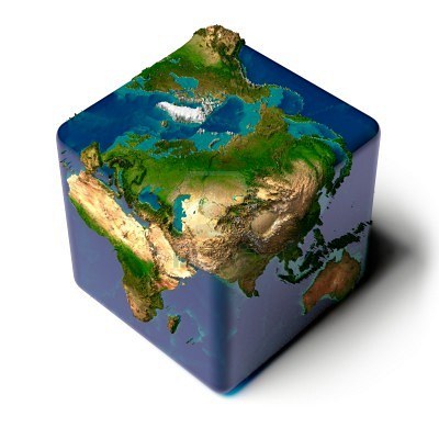
From this information we can derive a useful approximation to the earth's surface area. (We will need this later.) As you know, in GIS we use many different models of the earth's surface: a sphere, various ellipsoids, geoids, and so on. For the present purpose let's adopt a model that makes finding areas easy. I propose a cube(!). Sure, it's the wrong shape--but then so is a sphere, for that matter. So bear with me: if we make the cube about the same size as the earth--that is, with a "radius" of about 6000 kilometers--then it will form a box barely enclosing the earth. Thus, its surface area should be close to, but greater than, the earth's surface area. Each of the six faces of this cube is a square of side 2*6000 km. Its total surface area therefore equals 6 * (2*6000)^2 = 0.864 * 10^9 square kilometers. Let's just call this an even billion (10^9) square kilometers. We know this is an overestimate, but it's not a huge overestimate. (The correct surface area, as you can look up easily, is about half this value.)

(Image obtained from 123RF.)
The Pizza Principle
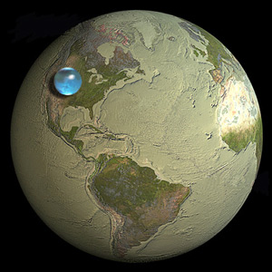
The method of the visualization in question is to represent volumes--the total volume of water and the volume of the earth--with Pseudo 3D spheres. Here is where geometric intuition is needed. Because intuition in 3D is not easy, let's sneak up on it by dropping a couple of dimensions:
Suppose a curve of length L is doubled in size. The new curve has double the length.
(Why? Because to measure the length of a curve, we approximate it with a polyline and sum the lengths of its segments. When you double the size of a segment, you double its length.)
Suppose a 2D region of area A is doubled in size. The new region has 2*2 = 4 times the area.
(Why? Because to measure a 2D region, we approximate it with a grid of tiny squares and add their areas. Upon doubling the region's size, each such square is doubled in size, too. Letting the side of an original square be s, its area will be s^2. The area of the doubled square therefore is (2s)^2 = 2^2 * s^2 = four times the original area.)
Practical application: If, say, a 10 inch pizza costs $5 in the restaurant, then a 20 inch pizza should cost around 4*$5 = $20 rather than just $10 because it involves four times the ingredients. This is the "Pizza Principle." (There's a hidden, but bad, math joke here involving pie.)
Suppose a 3D region of volume V is doubled in size. The new region has 2*2*2 = 8 times the volume.
(Why? Volumes are measured by approximating them with arrays of little cubes; a cube of side s has volume s^3; doubling the side of such a cube yields one with a volume of (2s)^3 = 8 * s^3.)
We can replace "doubling" in these arguments by any amount of rescaling, up or down. The result is that rescaling a 3D region by a factor x gives a new region that has x^3 = x*x*x times the old volume, no matter what shape the region originally was. Below, we will use this relationship in reverse. Specifically, suppose two 3D regions are scaled versions of each other (such as two spheres of possibly different sizes, or two cubes, or whatever). If one of them has y times the volume of each other, we solve y = x^3 to conclude that it is scaled by a factor of x = y^(1/3) (the cube root of y). For instance, if one sphere has 1,000 times the volume of another, then it is only 10 (= 1000^(1/3)) times bigger.
A Buffer Formula
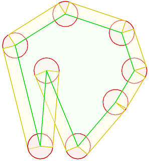
One more bit of intuition will be useful. To begin with, consider a curve in the plane (or on the surface of a sphere). Let its length be L. Thicken it a tiny bit: that is, buffer it by a distance r, say. The buffer is now a region with area A. Provided r is sufficiently small, then A will be very close to 2*r*L. (Why? Once more, approximate the curve by a polyline. Its buffer is a collection of rectangles, one per segment, plus a few bits and pieces of tiny circles at each vertex. When r is very small, only the rectangle areas contribute much to the total area. The area of such a rectangle is its length--the segment's original length--times the width, which is 2*r. Adding these all up gives the approximation.)

This diagram shows one-half of the buffer of a closed polyline, illustrating how it composed of rectangles and pieces of circles. The circles contribute little to the area and can be ignored for narrow buffers.
The spatial analog is to thicken a surface in three dimensions. When the surface area is A and the buffer distance is a small amount r, the measure of the resulting volume is approximately 2*r*A.
A Solution
From the last geometric insight we conclude that the volume of water on the earth is approximately equal to the earth's surface area times the average water depth. (The oceans form a thin "buffer" of the earth's surface.) Multiplying the billion square kilometer value derived earlier by a guess of, say, 2 kilometers average depth, gives two billion cubic kilometers. (More accurate calculations put the value near 1.4 billion cubic kilometers--but we figured we were overestimating anyway.)
Returning to the cube model of the earth, we ask: what size cube would have a volume of two billion km^3? Applying the Pizza Principle (in reverse), from the fact that one billion is the cube of one thousand, we see immediately that this cube would be 1,000 times larger than a cube containing two cubic kilometers. Temporarily ignoring the factor of two, it's also immediate that a cube of one km^3 must be exactly one kilometer on a size. Therefore, the two billion km^3 cube must be a little greater than 1,000 km on a side, somewhere around 1200 to 1300 km.
(Even if we made a large error in our approximations and estimates, this answer would not change much. For instance, if the true amount of water were only half a billion km^3 -- just one-quarter of our estimate -- the side of the resulting cube would still be 800 km. This is why we could get away with making such rough approximations all along.)
Remembering that in our cube model of the earth the surrounding cube is twelve thousand km on a side, and remembering that the Pizza Principle works regardless of actual shape (cube or sphere or anything in between, the predicted ratios of lengths and volumes still apply), we conclude:
All the earth's water could be formed into a ball approximately one-tenth the size of the earth itself.
A glance at the image in the question shows it is right on the mark. And we arrived at this conclusion knowing no more geometry than the Pizza Principle and a simple buffer formula applied to elementary facts about the earth we live on.


