replaced http://gis.stackexchange.com/ with https://gis.stackexchange.com/
Source Link

Generating LiDAR DEMs from unclassified point clouds with:

MCC-LIDAR is a command-line tool for processing discrete-return LIDAR data in forested environments (Evans & Hudak, 2007).

Workflow:

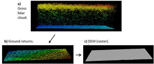
  • a) unclassified point cloud.
  • b) ground returns classified.
  • c) bare-earth DEM (raster).

enter image description here


Let's create a hypothetical situation to further provide an example with code.

MCC-LIDAR is installed in:

C:\MCC

The unclassified LiDAR point cloud (.las file) is in:

C:\lidar\project\unclassified.las  

The output which are going to be the bare-earth DEM is in:

C:\lidar\project\dem.asc  

The example below classifies ground returns with the MCC algorithm and create a bare-earth DEM with 1 meter resolution.

#MCC syntax: 
#command
#-s (spacing for scale domain)
#-t (curvature threshold)
#input_file (unclassified point cloud) 
#output_file (classified point cloud - ground -> class 2 and not ground -> class 1)
#-c (cell size of ground surface)
#output_DEM (raster surface interpolated from ground points)

C:\MCC\bin\mcc-lidar.exe -s 0.5 -t 0.07 C:\lidar\project\unclassified.las C:\lidar\project\classified.las -c 1 C:\lidar\project\dem.asc

To understand better how the scale (s) and the curvature threshold (t) parameters work, read: How to Run MCC-LiDAR and; Evans and Hudak (2007).

The parameters need to be calibrated to avoid commission/labeling errors (when a point is classified as belonging to the ground but actually it belongs to vegetation or buildings). For example:
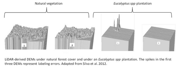
enter image description here

The MCC-LIDAR uses Thin Plate Spline (TPS) interpolation method to classify ground points and generate the bare-earth DEM.


References:

For more options about ground point classification algorithms, see Meng et al. (2010):

improved answer (readability)
Source Link
Andre Silva
  • 10.3k
  • 12
  • 55
  • 109

Constructing lidarGenerating LiDAR DEMs from unclassified point clouds with:

MCC-LIDAR is a command-line tool for processing discrete-return LIDAR data in forested environments"environments (Evans & Hudak, 2007).

Workflow illustration (gross cloud --> ground returns classified --> bare-earth DEM):

  • a) unclassified point cloud.
  • b) ground returns classified.
  • c) bare-earth DEM (raster).

Firstly, let'sLet's create a hypothetical situation to illustrate the below codefurther provide an example: with code.

MCC-LiDARLIDAR is installed under the following directoryin:

The lidarunclassified LiDAR point cloud (".las"las file) is stored in the below directory with the following name:

C:\lidar\project\cloud\lidar\project\unclassified.las  

The output which are going to be the bare-earth DEM will be stored as the followingis in:


Now, let's provide anThe example about how to classifybelow classifies ground returns with the MCC algorithm and create a bare-earth DEM with 1 meter resolution.

#MCC syntax:  
#command
#-s (spacing for scale domain)
#-t (curvature threshold)
#input_file (unclassified point cloud) 
#output_file (classified point cloud - ground -> class 2 and not ground -> class 1)
#-c (cell size of ground surface)
#output_DEM (raster surface interpolated from ground points)

C:\MCC\bin\mcc-lidar.exe -s 0.5 -t 0.07 C:\lidar\project\cloud\lidar\project\unclassified.las C:\lidar\project\mcc_ground_cloud\lidar\project\classified.las -c 1 C:\lidar\project\dem.asc

Read: How to Run MCC-LiDAR and also Evans & Hudak (2007) work (see "References" section below), toTo understand better how the scale (s) parameter and the curvature threshold parameter (t) worksparameters work, read: How to Run MCC-LiDAR and; Evans and Hudak (2007).
They

The parameters need to be calibrated to avoid the commission/labeling errors (when a point is classified as belonging to the ground but actually it belongs to vegetation or buildings). See the picture bellow. For example:

For more ground algorithm options see Meng et al. (2010).

The MCC-LiDARLIDAR uses the interpolation technique of Thin Plate Spline Thin Plate Spline (TPS) interpolation method to classify ground points and generate the bare-earth DEM from the classified (ground returns) lidar cloud.

References:


Evans, Jeffrey S.; Hudak, Andrew T. 2007. A multiscale curvature algorithm for classifying discrete return LiDAR in forested environments. IEEE Transactions on Geoscience and Remote Sensing. 45(4): 1029-1038.References:

Meng, X.; Currit, N.; Zhao, K. (2010). Ground Filtering Algorithms for Airborne LiDAR Data: A Review of Critical Issues. Remote Sensing, 2(3), 833–860. doi:10.3390/rs2030833For more options about ground point classification algorithms, see Meng et al. (2010):

Constructing lidar DEMs from unclassified point clouds with:

  • MCC-LiDAR using the Multiscale Curvature Classification (MCC) algorithm.

MCC-LIDAR is a command-line tool for processing discrete-return LIDAR data in forested environments" (Evans & Hudak, 2007).

Workflow illustration (gross cloud --> ground returns classified --> bare-earth DEM):

Firstly, let's create a hypothetical situation to illustrate the below code example:

MCC-LiDAR is installed under the following directory:

The lidar cloud (".las" file) is stored in the below directory with the following name:

C:\lidar\project\cloud.las  

The output which are going to be the bare-earth DEM will be stored as the following:


Now, let's provide an example about how to classify ground returns with the MCC algorithm and create a bare-earth DEM with 1 meter resolution.

#MCC syntax: #command #input_file #output_file #output_DEM
C:\MCC\bin\mcc-lidar.exe -s 0.5 -t 0.07 C:\lidar\project\cloud.las C:\lidar\project\mcc_ground_cloud.las -c 1 C:\lidar\project\dem.asc

Read: How to Run MCC-LiDAR and also Evans & Hudak (2007) work (see "References" section below), to understand better how the scale (s) parameter and the curvature threshold parameter (t) works.
They need to be calibrated to avoid the commission/labeling errors (when a point is classified as belonging to the ground but actually it belongs to vegetation or buildings). See the picture bellow.

For more ground algorithm options see Meng et al. (2010).

The MCC-LiDAR uses the interpolation technique of Thin Plate Spline (TPS) to generate the bare-earth DEM from the classified (ground returns) lidar cloud.

References:

Evans, Jeffrey S.; Hudak, Andrew T. 2007. A multiscale curvature algorithm for classifying discrete return LiDAR in forested environments. IEEE Transactions on Geoscience and Remote Sensing. 45(4): 1029-1038.

Meng, X.; Currit, N.; Zhao, K. (2010). Ground Filtering Algorithms for Airborne LiDAR Data: A Review of Critical Issues. Remote Sensing, 2(3), 833–860. doi:10.3390/rs2030833

Generating LiDAR DEMs from unclassified point clouds with:

MCC-LIDAR is a command-line tool for processing discrete-return LIDAR data in forested environments (Evans & Hudak, 2007).

Workflow:

  • a) unclassified point cloud.
  • b) ground returns classified.
  • c) bare-earth DEM (raster).

Let's create a hypothetical situation to further provide an example with code.

MCC-LIDAR is installed in:

The unclassified LiDAR point cloud (.las file) is in:

C:\lidar\project\unclassified.las  

The output which are going to be the bare-earth DEM is in:

The example below classifies ground returns with the MCC algorithm and create a bare-earth DEM with 1 meter resolution.

#MCC syntax:  
#command
#-s (spacing for scale domain)
#-t (curvature threshold)
#input_file (unclassified point cloud) 
#output_file (classified point cloud - ground -> class 2 and not ground -> class 1)
#-c (cell size of ground surface)
#output_DEM (raster surface interpolated from ground points)

C:\MCC\bin\mcc-lidar.exe -s 0.5 -t 0.07 C:\lidar\project\unclassified.las C:\lidar\project\classified.las -c 1 C:\lidar\project\dem.asc

To understand better how the scale (s) and the curvature threshold (t) parameters work, read: How to Run MCC-LiDAR and; Evans and Hudak (2007).

The parameters need to be calibrated to avoid commission/labeling errors (when a point is classified as belonging to the ground but actually it belongs to vegetation or buildings). For example:

The MCC-LIDAR uses Thin Plate Spline (TPS) interpolation method to classify ground points and generate the bare-earth DEM.


References:

For more options about ground point classification algorithms, see Meng et al. (2010):

removed/replaced broken links and readability
Source Link
Andre Silva
  • 10.3k
  • 12
  • 55
  • 109

Constructing lidar DEMs from unclassified point clouds with:

  • MCC-LiDAR using the Multiscale Curvature Classification (MCC) algorithm.

MCC-LIDAR is a command-line tool for processing discrete-return LIDAR data in forested environments" (Evans & Hudak, 2007).

Workflow illustration (gross cloud --> ground returns classified --> bare-earth DEM):

enter image description here


Firstly, let's create a hypothetical situation to illustrate the below code example:

MCC-LiDAR is installed under the following directory:

C:\MCC

The lidar cloud (".las" file) is stored in the below directory with the following name:

C:\lidar\project\cloud.las  

The output which are going to be the bare-earth DEM will be stored as the following:

C:\lidar\project\dem.asc  

Now, let's provide an example about how to classify ground returns with the MCC algorithm and create a bare-earth DEM with 1 meter resolution.

#MCC syntax: #command #input_file #output_file #output_DEM
C:\MCC\bin\mcc-lidar.exe -s 0.5 -t 0.07 C:\lidar\project\cloud.las C:\lidar\project\mcc_ground_cloud.las -c 1 C:\lidar\project\dem.asc

Read: How to Run MCC-LiDAR link and also Evans & Hudak (2007) work (see "References" section below),
to to understand better how the scale (s) parameter and the curvature threshold parameter (t) works.
They need to be calibrated to avoid the commission/labeling errors (when a point is classified as belonging to the ground but actually it belongs to vegetation or buildings). See the picture bellow.

enter image description here

For more ground algorithm options see Meng et al. (2010).

The MCC-LiDAR uses the interpolation technique of Thin Plate Spline (TPS) to generate the bare-earth DEM from the classified (ground returns) lidar cloud.

References:

Evans, Jeffrey S.; Hudak, Andrew T. 2007. A multiscale curvature algorithm for classifying discrete return LiDAR in forested environments. IEEE Transactions on Geoscience and Remote Sensing. 45(4): 1029-1038.

Meng, X.,; Currit, N., &; Zhao, K. (2010). Ground Filtering Algorithms for Airborne LiDAR Data: A Review of Critical IssuesGround Filtering Algorithms for Airborne LiDAR Data: A Review of Critical Issues. Remote Sensing, 2(3), 833–860. doi:10.3390/rs2030833

Silva, A. G. P. da, Gorgens, E. B., Rodriguez, L. C. E., Silva, C. A., Alvares, C. A., Campoe, O. C., & Stape, J. L. (2012). Influência da janela do filtro de terreno em dados LiDAR sob duas coberturas florestais. In C. Lingnau, J. R. dos Santos, & E. da S. Lopes (Eds.), X Seminário de Atualização em Sensoriamento Remoto e SIG Aplicados à Engenharia Florestal (Vol. 10, pp. 65–72). Curitiba, Brazil: 10seminarioflorestal.com.br.
*abstract and pictures' caption are available in English.

Constructing lidar DEMs from unclassified point clouds with:

  • MCC-LiDAR using the Multiscale Curvature Classification (MCC) algorithm.

MCC-LIDAR is a command-line tool for processing discrete-return LIDAR data in forested environments" (Evans & Hudak, 2007).

Workflow illustration (gross cloud --> ground returns classified --> bare-earth DEM):

enter image description here


Firstly, let's create a hypothetical situation to illustrate the below code example:

MCC-LiDAR is installed under the following directory:

C:\MCC

The lidar cloud (".las" file) is stored in the below directory with the following name:

C:\lidar\project\cloud.las  

The output which are going to be the bare-earth DEM will be stored as the following:

C:\lidar\project\dem.asc  

Now, let's provide an example about how to classify ground returns with the MCC algorithm and create a bare-earth DEM with 1 meter resolution.

#MCC syntax: #command #input_file #output_file #output_DEM
C:\MCC\bin\mcc-lidar.exe -s 0.5 -t 0.07 C:\lidar\project\cloud.las C:\lidar\project\mcc_ground_cloud.las -c 1 C:\lidar\project\dem.asc

Read: How to Run MCC-LiDAR link and Evans & Hudak (2007) work (see "References" section below),
to understand better how the scale (s) parameter and the curvature threshold parameter (t) works.
They need to be calibrated to avoid the commission/labeling errors (when a point is classified as belonging to the ground but actually it belongs to vegetation or buildings). See picture bellow.

enter image description here

For more ground algorithm options see Meng et al. (2010).

The MCC-LiDAR uses the interpolation technique of Thin Plate Spline (TPS) to generate the bare-earth DEM from the classified (ground returns) lidar cloud.

References:

Evans, Jeffrey S.; Hudak, Andrew T. 2007. A multiscale curvature algorithm for classifying discrete return LiDAR in forested environments. IEEE Transactions on Geoscience and Remote Sensing. 45(4): 1029-1038.

Meng, X., Currit, N., & Zhao, K. (2010). Ground Filtering Algorithms for Airborne LiDAR Data: A Review of Critical Issues. Remote Sensing, 2(3), 833–860. doi:10.3390/rs2030833

Silva, A. G. P. da, Gorgens, E. B., Rodriguez, L. C. E., Silva, C. A., Alvares, C. A., Campoe, O. C., & Stape, J. L. (2012). Influência da janela do filtro de terreno em dados LiDAR sob duas coberturas florestais. In C. Lingnau, J. R. dos Santos, & E. da S. Lopes (Eds.), X Seminário de Atualização em Sensoriamento Remoto e SIG Aplicados à Engenharia Florestal (Vol. 10, pp. 65–72). Curitiba, Brazil: 10seminarioflorestal.com.br.
*abstract and pictures' caption are available in English.

Constructing lidar DEMs from unclassified point clouds with:

  • MCC-LiDAR using the Multiscale Curvature Classification (MCC) algorithm.

MCC-LIDAR is a command-line tool for processing discrete-return LIDAR data in forested environments" (Evans & Hudak, 2007).

Workflow illustration (gross cloud --> ground returns classified --> bare-earth DEM):

enter image description here


Firstly, let's create a hypothetical situation to illustrate the below code example:

MCC-LiDAR is installed under the following directory:

C:\MCC

The lidar cloud (".las" file) is stored in the below directory with the following name:

C:\lidar\project\cloud.las  

The output which are going to be the bare-earth DEM will be stored as the following:

C:\lidar\project\dem.asc  

Now, let's provide an example about how to classify ground returns with the MCC algorithm and create a bare-earth DEM with 1 meter resolution.

#MCC syntax: #command #input_file #output_file #output_DEM
C:\MCC\bin\mcc-lidar.exe -s 0.5 -t 0.07 C:\lidar\project\cloud.las C:\lidar\project\mcc_ground_cloud.las -c 1 C:\lidar\project\dem.asc

Read: How to Run MCC-LiDAR and also Evans & Hudak (2007) work (see "References" section below), to understand better how the scale (s) parameter and the curvature threshold parameter (t) works.
They need to be calibrated to avoid the commission/labeling errors (when a point is classified as belonging to the ground but actually it belongs to vegetation or buildings). See the picture bellow.

enter image description here

For more ground algorithm options see Meng et al. (2010).

The MCC-LiDAR uses the interpolation technique of Thin Plate Spline (TPS) to generate the bare-earth DEM from the classified (ground returns) lidar cloud.

References:

Evans, Jeffrey S.; Hudak, Andrew T. 2007. A multiscale curvature algorithm for classifying discrete return LiDAR in forested environments. IEEE Transactions on Geoscience and Remote Sensing. 45(4): 1029-1038.

Meng, X.; Currit, N.; Zhao, K. (2010). Ground Filtering Algorithms for Airborne LiDAR Data: A Review of Critical Issues. Remote Sensing, 2(3), 833–860. doi:10.3390/rs2030833

Source Link
Andre Silva
  • 10.3k
  • 12
  • 55
  • 109
Loading