added 804 characters in body
Source Link
Dan C
  • 12.3k
  • 11
  • 61
  • 87

Did you edit the data in that table at all? It's strange how there is one row with its lat/longs in DDMMSS when all the others (the ones that aren't blank) are in decimal degrees. Also, do the points which are missing positional data actually show up in ArcMap? Are they where they're supposed to be?

As far as the missing data, it looks like everything went fine during data collection on 2/4/2014, all those points have lat/longs, etc. But on 3/4, they don't. I suspect the Trimble is working fine but some other problem cropped up during data collection: too few satellites to get a location fix, for example, or maybe the field team didn't record enough points at each location to get a fix. You could export the file again, but modify the Export Setup to include the data's DOP values, Correction Status, and number of positions recorded to diagnose the problem.

ETA: In light of your comment that differential correction isn't working, I think that's probably the problem. If your export is set up to not export any uncorrected positions (which is the default setting, I think), and you weren't getting real-time corrections in the field on 3/4, then your features would export with no positions, and therefore no lat/long, precision, or height.

So I'd try to get differential correction working first. If it's not able to transfer base station files, you can try:

  • Update the list of Base Providers in the Differential Correction utility (under Base Data, click Select, then Update List).
  • Make sure your internet settings (or your company's internet settings) aren't blocking access to the download site or to Trimble.
  • Try a different base station.

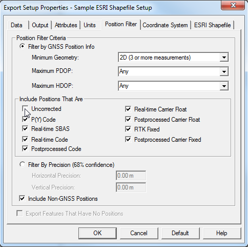
If you want to confirm that the lack of differential correction is the problem, you can change your Export Setup to include all positions when exporting. It's under the Position Filter tab in the Export Setup Properties:
enter image description here

I believe that with all those boxes checked, you should see lat/longs for all your points in the exported file. Of course, without differential correction, they will probably be a little further away from their actual location than the corrected points.

Did you edit the data in that table at all? It's strange how there is one row with its lat/longs in DDMMSS when all the others (the ones that aren't blank) are in decimal degrees. Also, do the points which are missing positional data actually show up in ArcMap? Are they where they're supposed to be?

As far as the missing data, it looks like everything went fine during data collection on 2/4/2014, all those points have lat/longs, etc. But on 3/4, they don't. I suspect the Trimble is working fine but some other problem cropped up during data collection: too few satellites to get a location fix, for example, or maybe the field team didn't record enough points at each location to get a fix. You could export the file again, but modify the Export Setup to include the data's DOP values, Correction Status, and number of positions recorded to diagnose the problem.

ETA: In light of your comment that differential correction isn't working, I think that's probably the problem. If your export is set up to not export any uncorrected positions (which is the default setting, I think), and you weren't getting real-time corrections in the field on 3/4, then your features would export with no positions, and therefore no lat/long, precision, or height.

So I'd try to get differential correction working first. If it's not able to transfer base station files, you can try:

  • Update the list of Base Providers in the Differential Correction utility (under Base Data, click Select, then Update List).
  • Make sure your internet settings (or your company's internet settings) aren't blocking access to the download site or to Trimble.
  • Try a different base station.

If you want to confirm that the lack of differential correction is the problem, you can change your Export Setup to include all positions when exporting. It's under the Position Filter tab in the Export Setup Properties:

enter image description here

I believe that with all those boxes checked, you should see lat/longs for all your points in the exported file. Of course, without differential correction, they will probably be a little further away from their actual location than the corrected points.

Source Link
Dan C
  • 12.3k
  • 11
  • 61
  • 87

Did you edit the data in that table at all? It's strange how there is one row with its lat/longs in DDMMSS when all the others (the ones that aren't blank) are in decimal degrees. Also, do the points which are missing positional data actually show up in ArcMap? Are they where they're supposed to be?

As far as the missing data, it looks like everything went fine during data collection on 2/4/2014, all those points have lat/longs, etc. But on 3/4, they don't. I suspect the Trimble is working fine but some other problem cropped up during data collection: too few satellites to get a location fix, for example, or maybe the field team didn't record enough points at each location to get a fix. You could export the file again, but modify the Export Setup to include the data's DOP values, Correction Status, and number of positions recorded to diagnose the problem.