After struggling with this question ten years ago, and finding many confusing things written about the topic, I published a brief article in Directions Magazine that presented an answer as simply, plainly, and accurately as I could make it. The following is excerpted from that article.
##Reprojecting geographic features##
Reprojecting geographic features
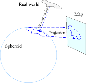
Two things must happen when you draw a map: features in the real world must be "georeferenced" to a spheroid and the spheroid must be projected onto the paper.

The spheroid models the shape of the earth's surface. It is an idealization that does not account for local changes in topography.
Georeferencing assigns locations (in three dimensions!) to points on a spheroid.
Projecting is an operation that mathematically distorts and shrinks a portion of the spheroid onto flat paper. Projecting can be undone ("inverted"). "Unprojection" expands a feature on a map and plasters it back onto the spheroid.It, too, is a mathematical operation.
Georeferencing is done with a datum. A datum is usually given by a starting point and direction: it specifies where a clearly identifiable point on earth (the base point) should appear on the spheroid and it shows where a base direction, such as north, points on the spheroid at the base point. The base point and direction allow surveyors to determine the distance and angle of any other point on the earth. Moving in the corresponding direction on the spheroid for the same distance determines where the new point should go on the spheroid.
Spheroids have coordinates. They are latitude and longitude. (Geodetic) latitude is the angle made by a vertical line to the horizontal. It is not necessarily the same angle made by "straight up," because the latter is distorted by gravitational variation over the earth. It is not necessarily the angle made by a line to the center of the earth, because most spheroids have an elliptical cross-section, not a circular one.
Therefore, georeferencing endows points near the earth with latitude, longitude, and height coordinates.
(Subsequent sections discuss Change of datum, How to relate two maps, The wrong way to do it, and North America is a special case.)
