deleted 175 characters in body
Source Link
PolyGeo
  • 65.4k
  • 29
  • 114
  • 345

Well, big bros don't like lengthy chats on this forum. We are left with 2 options. My one - make it an answer, yours - accept it before reading further.

In short you have to modify DSM inside building outline.

  1. Use Geoprocessing - Environment _ Spatial Extent to set it to DSM.
  2. Use Geoprocessing - Environment _ Raster Analysis - Cell Size to set it same as DSM.
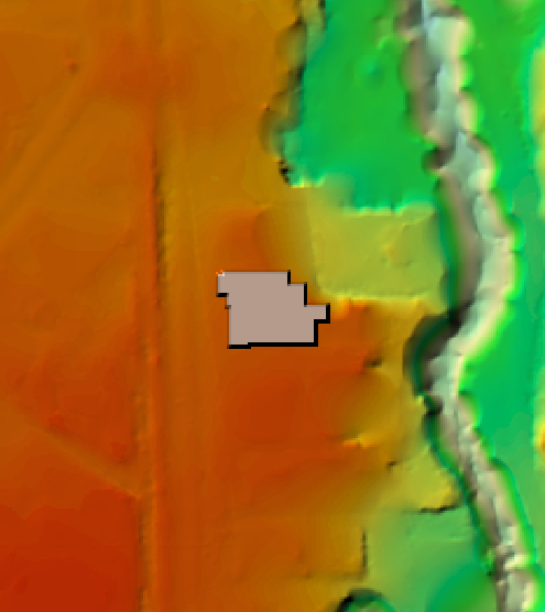
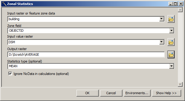
  3. Calculate average elevation for building, using it's outline enter image description here
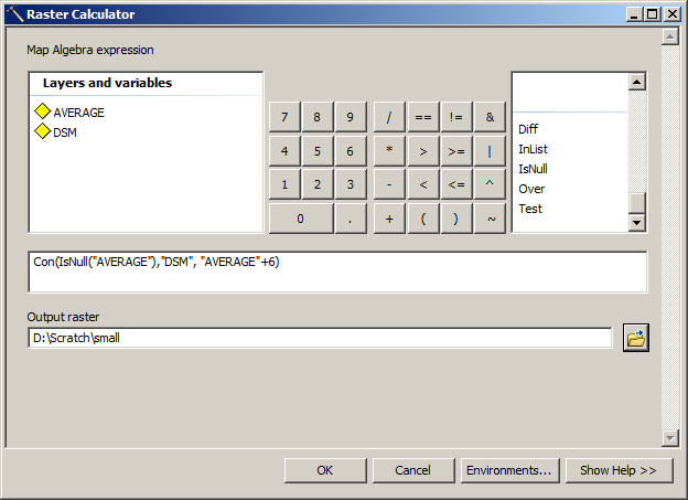
  4. Use Raster Calculator to raise a part of your elevation: enter image description here
This will result in changing your of elevation from:
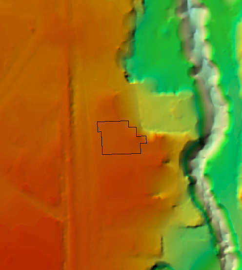
enter image description here

to

enter image description here

Repeat your viewshed analysis using what I call 'small' in above example.

When placing observers, I'd suggest to put them on concentric circles around the building. Expect to see bigger 'skyline pollution' for points closer to building in low places. Also avoid placing observers inside other buildings, because you'll have to deal with the issue of 'where the window are'. (I'd even erase buildings outlines from viewsheds).

On the other hand if this research is about animal welfare, e.g. 'California's Association of Stargazing Persians' you might very well place them on the roofs. Don't forget to place a couple on building of interest. These two will benefit from building upgrade and might request name changes later to Hillary & Tenzing. https://en.wikipedia.org/wiki/1953_British_Mount_Everest_expedition

TGIF

In short you have to modify DSM inside building outline.

  1. Use Geoprocessing - Environment _ Spatial Extent to set it to DSM.
  2. Use Geoprocessing - Environment _ Raster Analysis - Cell Size to set it same as DSM.
  3. Calculate average elevation for building, using it's outline enter image description here
  4. Use Raster Calculator to raise a part of your elevation: enter image description here

This will result in changing your of elevation from:

enter image description here

to

enter image description here

Repeat your viewshed analysis using what I call 'small' in above example.

When placing observers, I'd suggest to put them on concentric circles around the building. Expect to see bigger 'skyline pollution' for points closer to building in low places. Also avoid placing observers inside other buildings, because you'll have to deal with the issue of 'where the window are'. (I'd even erase buildings outlines from viewsheds).

On the other hand if this research is about animal welfare, e.g. 'California's Association of Stargazing Persians' you might very well place them on the roofs. Don't forget to place a couple on building of interest. These two will benefit from building upgrade and might request name changes later to Hillary & Tenzing. https://en.wikipedia.org/wiki/1953_British_Mount_Everest_expedition

added 72 characters in body
Source Link
FelixIP
  • 23.3k
  • 3
  • 31
  • 62

Well, big bros don't like lengthy chats on this forum. We are left with 2 options. My one - make it an answer, yours - accept it before reading further.

In short you have to modify DSM inside building outline.

  1. Use Geoprocessing - Environment _ Spatial Extent to set it to DSM.
  2. Use Geoprocessing - Environment _ Raster Analysis - Cell Size to set it same as DSM.
  3. Calculate average elevation for building, using it's outline enter image description here
  4. Use Raster Calculator to raise a part of your elevation: enter image description here

This will result in changing your of elevation from:

enter image description here

to

enter image description here

Repeat your viewshed analysis using what I call 'small' in above example.

When placing observers, I'd suggest to put them on concentric circles around the building. Expect to see bigger 'skyline pollution' for points closer to building in low places. Also avoid placing observers inside other buildings, because you'll have to deal with the issue of 'where the window are'. (I'd even erase buildings outlines from viewsheds).

On the other hand if this research is about animal welfare, e.g. 'California's Association of Stargazing Persians' you might very well place them on the roofs. Don't forget to place a couple on building of interest. These two will benefit from building upgrade and might request name changes later to Hillary & TensingTenzing. https://en.wikipedia.org/wiki/1953_British_Mount_Everest_expedition

TGIF

Well, big bros don't like lengthy chats on this forum. We are left with 2 options. My one - make it an answer, yours - accept it before reading further.

In short you have to modify DSM inside building outline.

  1. Use Geoprocessing - Environment _ Spatial Extent to set it to DSM.
  2. Use Geoprocessing - Environment _ Raster Analysis - Cell Size to set it same as DSM.
  3. Calculate average elevation for building, using it's outline enter image description here
  4. Use Raster Calculator to raise a part of your elevation: enter image description here

This will result in changing your of elevation from:

enter image description here

to

enter image description here

Repeat your viewshed analysis using what I call 'small' in above example.

When placing observers, I'd suggest to put them on concentric circles around the building. Expect to see bigger 'skyline pollution' for points closer to building in low places. Also avoid placing observers inside other buildings, because you'll have to deal with the issue of 'where the window are'. (I'd even erase buildings outlines from viewsheds).

On the other hand if this research is about animal welfare, e.g. 'California's Association of Stargazing Persians' you might very well place them on the roofs. Don't forget to place a couple on building of interest. These two will benefit from building upgrade and might request name changes later to Hillary & Tensing. TGIF

Well, big bros don't like lengthy chats on this forum. We are left with 2 options. My one - make it an answer, yours - accept it before reading further.

In short you have to modify DSM inside building outline.

  1. Use Geoprocessing - Environment _ Spatial Extent to set it to DSM.
  2. Use Geoprocessing - Environment _ Raster Analysis - Cell Size to set it same as DSM.
  3. Calculate average elevation for building, using it's outline enter image description here
  4. Use Raster Calculator to raise a part of your elevation: enter image description here

This will result in changing your of elevation from:

enter image description here

to

enter image description here

Repeat your viewshed analysis using what I call 'small' in above example.

When placing observers, I'd suggest to put them on concentric circles around the building. Expect to see bigger 'skyline pollution' for points closer to building in low places. Also avoid placing observers inside other buildings, because you'll have to deal with the issue of 'where the window are'. (I'd even erase buildings outlines from viewsheds).

On the other hand if this research is about animal welfare, e.g. 'California's Association of Stargazing Persians' you might very well place them on the roofs. Don't forget to place a couple on building of interest. These two will benefit from building upgrade and might request name changes later to Hillary & Tenzing. https://en.wikipedia.org/wiki/1953_British_Mount_Everest_expedition

TGIF

Source Link
FelixIP
  • 23.3k
  • 3
  • 31
  • 62

Well, big bros don't like lengthy chats on this forum. We are left with 2 options. My one - make it an answer, yours - accept it before reading further.

In short you have to modify DSM inside building outline.

  1. Use Geoprocessing - Environment _ Spatial Extent to set it to DSM.
  2. Use Geoprocessing - Environment _ Raster Analysis - Cell Size to set it same as DSM.
  3. Calculate average elevation for building, using it's outline enter image description here
  4. Use Raster Calculator to raise a part of your elevation: enter image description here

This will result in changing your of elevation from:

enter image description here

to

enter image description here

Repeat your viewshed analysis using what I call 'small' in above example.

When placing observers, I'd suggest to put them on concentric circles around the building. Expect to see bigger 'skyline pollution' for points closer to building in low places. Also avoid placing observers inside other buildings, because you'll have to deal with the issue of 'where the window are'. (I'd even erase buildings outlines from viewsheds).

On the other hand if this research is about animal welfare, e.g. 'California's Association of Stargazing Persians' you might very well place them on the roofs. Don't forget to place a couple on building of interest. These two will benefit from building upgrade and might request name changes later to Hillary & Tensing. TGIF