deleted 8 characters in body
Source Link
PolyGeo
  • 65.4k
  • 29
  • 114
  • 345

I am new to GIS and I try to use the following code to display a pacific-centered world map.

+proj=robin +lon_0=-198 +x_0=0 +y_0=0 +ellps=WGS84 +datum=WGS84 +units=m +no_defs

However the map displayed is a bit messy as below: enter image description here
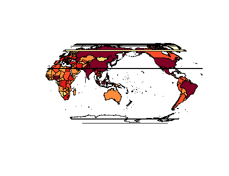
I'm wondering whether I can limit the map within two longitude lines to eliminate those horizontal lines. However I don't know the proj4 code to realize this. Thanks.

I am new to GIS and I try to use the following code to display a pacific-centered world map.

+proj=robin +lon_0=-198 +x_0=0 +y_0=0 +ellps=WGS84 +datum=WGS84 +units=m +no_defs

However the map displayed is a bit messy as below: enter image description here

I'm wondering whether I can limit the map within two longitude lines to eliminate those horizontal lines. However I don't know the proj4 code to realize this.

added 2 characters in body
Source Link

I am new to GIS and I try to use the following code to display a pacific-centered world map.

+proj=robin +lon_0=-198 +x_0=0 +y_0=0 +ellps=WGS84 +datum=WGS84 +units=m +no_defs

However the map displaydisplayed is a bit messy as below: enter image description here

I'm wondering whether I can limit the map within two longitude lines to eliminate those horizontal lines. However I don't know the proj4 code to realize this. Thanks.

I am new to GIS and I try to use the following code to display a pacific-centered world map.

+proj=robin +lon_0=-198 +x_0=0 +y_0=0 +ellps=WGS84 +datum=WGS84 +units=m +no_defs

However the map display is a bit messy as below: enter image description here

I'm wondering whether I can limit the map within two longitude lines to eliminate those horizontal lines. However I don't know the proj4 code to realize this. Thanks.

I am new to GIS and I try to use the following code to display a pacific-centered world map.

+proj=robin +lon_0=-198 +x_0=0 +y_0=0 +ellps=WGS84 +datum=WGS84 +units=m +no_defs

However the map displayed is a bit messy as below: enter image description here

I'm wondering whether I can limit the map within two longitude lines to eliminate those horizontal lines. However I don't know the proj4 code to realize this. Thanks.

format as code
Source Link
Stephen Lead
  • 21.3k
  • 18
  • 114
  • 241

I am new to GIS and I try to use the following code to display a pacific-centered world map.

+proj=robin +lon_0=-198 +x_0=0 +y_0=0 +ellps=WGS84 +datum=WGS84 +units=m +no_defs

+proj=robin +lon_0=-198 +x_0=0 +y_0=0 +ellps=WGS84 +datum=WGS84 +units=m +no_defs

However the map display is a bit messy as below: enter image description here

I'm wondering whether I can limit the map within two longitude lines to eliminate those horizontal lines. However I don't know the proj4 code to realize this. Thanks.

I am new to GIS and I try to use the following code to display a pacific-centered world map.

+proj=robin +lon_0=-198 +x_0=0 +y_0=0 +ellps=WGS84 +datum=WGS84 +units=m +no_defs

However the map display is a bit messy as below: enter image description here

I'm wondering whether I can limit the map within two longitude lines to eliminate those horizontal lines. However I don't know the proj4 code to realize this. Thanks.

Source Link
Loading