added 79 characters in body
Source Link
ThomasG77
  • 31.2k
  • 1
  • 55
  • 95

You should use QuickMapServices plugin instead of OpenLayers Plugin.

If you want to use coordinates to display point

To make things work, I just used the Layer > AddLayer > Add Delimited TextLayer

It seems the trailing character ` in line 2 of your sample make the layer opening fails. I also renamed "gpsPoint=lat" to "lat" and "gpsPoint=lon" to "lon" (not mandatory, you should avoid field names like this)

See the screenshots for detailed use case

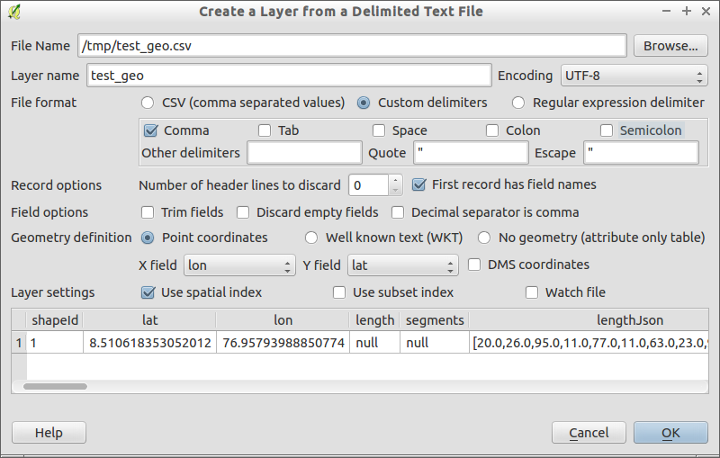
Parameters to open specific CSV file

I didn't tick the CSV file format because your CSV is quoted.

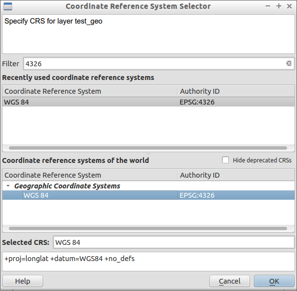
Projection to choose

EPSG 4326 = projection of GPS = decimal degrees = latitude, longitude

If you want to use the wkt polygon

As stated by other in comment, it works but it seems you want wkt polygon.

It seems that lat, lon order is reverted.

  • You will have to open the csv file like with previous solution but choose Geometry definition to WKT. You will see the position is wrong.
  • You have to save the layer as Shapefile with Save As and add it to the canevas
  • Install the plugin SWAP XYUse QGIS native Processing Toolbox algorithm "Swap X and apply the swap process to the previous shapefile layerY coordinates" Install the plugin SWAP XY and apply the swap process to the previous shapefile layer

PS: it seems that lat,lon or lon,lat order both exists in practice with WKT.

You should use QuickMapServices plugin instead of OpenLayers Plugin.

If you want to use coordinates to display point

To make things work, I just used the Layer > AddLayer > Add Delimited TextLayer

It seems the trailing character ` in line 2 of your sample make the layer opening fails. I also renamed "gpsPoint=lat" to "lat" and "gpsPoint=lon" to "lon" (not mandatory, you should avoid field names like this)

See the screenshots for detailed use case

Parameters to open specific CSV file

I didn't tick the CSV file format because your CSV is quoted.

Projection to choose

EPSG 4326 = projection of GPS = decimal degrees = latitude, longitude

If you want to use the wkt polygon

As stated by other in comment, it works but it seems you want wkt polygon.

It seems that lat, lon order is reverted.

  • You will have to open the csv file like with previous solution but choose Geometry definition to WKT. You will see the position is wrong.
  • You have to save the layer as Shapefile with Save As and add it to the canevas
  • Install the plugin SWAP XY and apply the swap process to the previous shapefile layer

PS: it seems that lat,lon or lon,lat order both exists in practice with WKT.
You should use QuickMapServices plugin instead of OpenLayers Plugin.

If you want to use coordinates to display point

To make things work, I just used the Layer > AddLayer > Add Delimited TextLayer

It seems the trailing character ` in line 2 of your sample make the layer opening fails. I also renamed "gpsPoint=lat" to "lat" and "gpsPoint=lon" to "lon" (not mandatory, you should avoid field names like this)

See the screenshots for detailed use case

Parameters to open specific CSV file

I didn't tick the CSV file format because your CSV is quoted.

Projection to choose

EPSG 4326 = projection of GPS = decimal degrees = latitude, longitude

If you want to use the wkt polygon

As stated by other in comment, it works but it seems you want wkt polygon.

It seems that lat, lon order is reverted.

  • You will have to open the csv file like with previous solution but choose Geometry definition to WKT. You will see the position is wrong.
  • You have to save the layer as Shapefile with Save As and add it to the canevas
  • Use QGIS native Processing Toolbox algorithm "Swap X and Y coordinates" Install the plugin SWAP XY and apply the swap process to the previous shapefile layer

PS: it seems that lat,lon or lon,lat order both exists in practice with WKT.
added 614 characters in body
Source Link
ThomasG77
  • 31.2k
  • 1
  • 55
  • 95

You should use QuickMapServices plugin instead of OpenLayers Plugin.

If you want to use coordinates to display point

To make things work, I just used the Layer > AddLayer > Add Delimited TextLayer

It seems the trailing character ` in line 2 of your sample make the layer opening fails. I also renamed "gpsPoint=lat" to "lat" and "gpsPoint=lon" to "lon" (not mandatory, you should avoid field names like this)

See the screenshots for detailed use case

Parameters to open specific CSV file

I didn't tick the CSV file format because your CSV is quoted.

Projection to choose

EPSG 4326 = projection of GPS = decimal degrees = latitude, longitude

If you want to use the wkt polygon

As stated by other in comment, it works but it seems you want wkt polygon.

It seems that lat, lon order is reverted.

  • You will have to open the csv file like with previous solution but choose Geometry definition to WKT. You will see the position is wrong.
  • You have to save the layer as Shapefile with Save As and add it to the canevas
  • Install the plugin SWAP XY and apply the swap process to the previous shapefile layer

PS: it seems that lat,lon or lon,lat order both exists in practice with WKT.

You should use QuickMapServices plugin instead of OpenLayers Plugin.

To make things work, I just used the Layer > AddLayer > Add Delimited TextLayer

It seems the trailing character ` in line 2 of your sample make the layer opening fails. I also renamed "gpsPoint=lat" to "lat" and "gpsPoint=lon" to "lon" (not mandatory, you should avoid field names like this)

See the screenshots for detailed use case

Parameters to open specific CSV file

I didn't tick the CSV file format because your CSV is quoted.

Projection to choose

EPSG 4326 = projection of GPS = decimal degrees = latitude, longitude

You should use QuickMapServices plugin instead of OpenLayers Plugin.

If you want to use coordinates to display point

To make things work, I just used the Layer > AddLayer > Add Delimited TextLayer

It seems the trailing character ` in line 2 of your sample make the layer opening fails. I also renamed "gpsPoint=lat" to "lat" and "gpsPoint=lon" to "lon" (not mandatory, you should avoid field names like this)

See the screenshots for detailed use case

Parameters to open specific CSV file

I didn't tick the CSV file format because your CSV is quoted.

Projection to choose

EPSG 4326 = projection of GPS = decimal degrees = latitude, longitude

If you want to use the wkt polygon

As stated by other in comment, it works but it seems you want wkt polygon.

It seems that lat, lon order is reverted.

  • You will have to open the csv file like with previous solution but choose Geometry definition to WKT. You will see the position is wrong.
  • You have to save the layer as Shapefile with Save As and add it to the canevas
  • Install the plugin SWAP XY and apply the swap process to the previous shapefile layer

PS: it seems that lat,lon or lon,lat order both exists in practice with WKT.

Source Link
ThomasG77
  • 31.2k
  • 1
  • 55
  • 95

You should use QuickMapServices plugin instead of OpenLayers Plugin.

To make things work, I just used the Layer > AddLayer > Add Delimited TextLayer

It seems the trailing character ` in line 2 of your sample make the layer opening fails. I also renamed "gpsPoint=lat" to "lat" and "gpsPoint=lon" to "lon" (not mandatory, you should avoid field names like this)

See the screenshots for detailed use case

Parameters to open specific CSV file

I didn't tick the CSV file format because your CSV is quoted.

Projection to choose

EPSG 4326 = projection of GPS = decimal degrees = latitude, longitude