removed false "rile"
Source Link
Vince
  • 20.3k
  • 16
  • 48
  • 65

Shapefile polygons are constructed from one or more closed rings. If a shape has multiple rings, they can be exterior and interior (e.g., form a doughnut), or multiple exterior (e.g., island chain). enter image description here
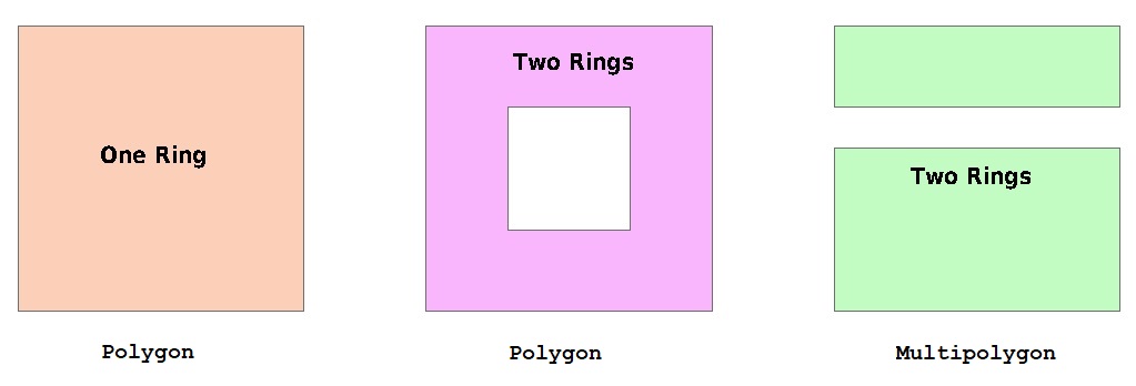
Of course, having multiple exteriors doesn't prevent having one or more interior rings on each shape. The shapefile specification does state that:

  1. Exterior rings must be clockwise, while interior rings must be counter-clockwise (this convention is known as right-hand rule since the shape would always be on your right-hand side as you walk the perimeter; unfortunately, it can also be known as left-hand rule, because the exterior rings follow the direction of a curled left hand with the thumb pointed upward from the top of the figure)
  2. InteriorInterior rings must always follow the exterior ring they partition "The order of rings mustin the points array is not significant." (though in practice, at least for Esri-generated shapefiles, interior rings nearly always follow the exterior ring they partition)
  3. Neither exterior or interior rings may overlap or share a common border (such features may be populated, but they are invalid and may cause strange geoprocessing failures).

Shapefiles do not make a distinction between these objects -- they are all polygons (and each geometry is associated with one dBase record).

However, some tools do make a distinction, QGIS being one of them. If all you will ever have in a shapefile is simple one-ring shapes, then you can safely choose Polygon. If the shapes may contain "holes", it is also safe to choose Polygon. If, however, some shapes may contain multiple exterior rings then you need to choose Multipolygon.

Shapefile polygons are constructed from one or more closed rings. If a shape has multiple rings, they can be exterior and interior (e.g., form a doughnut), or multiple exterior (e.g., island chain). enter image description here

Of course, having multiple exteriors doesn't prevent having one or more interior rings on each shape. The shapefile specification does state that:

  1. Exterior rings must be clockwise, while interior rings must be counter-clockwise (this convention is known as right-hand rule since the shape would always be on your right-hand side as you walk the perimeter; unfortunately, it can also be known as left-hand rule, because the exterior rings follow the direction of a curled left hand with the thumb pointed upward from the top of the figure)
  2. Interior rings must always follow the exterior ring they partition
  3. Neither exterior or interior rings may overlap or share a common border (such features may be populated, but they are invalid and may cause strange geoprocessing failures).

Shapefiles do not make a distinction between these objects -- they are all polygons (and each geometry is associated with one dBase record).

However, some tools do make a distinction, QGIS being one of them. If all you will ever have in a shapefile is simple one-ring shapes, then you can safely choose Polygon. If the shapes may contain "holes", it is also safe to choose Polygon. If, however, some shapes may contain multiple exterior rings then you need to choose Multipolygon.

Shapefile polygons are constructed from one or more closed rings. If a shape has multiple rings, they can be exterior and interior (e.g., form a doughnut), or multiple exterior (e.g., island chain). enter image description here

Of course, having multiple exteriors doesn't prevent having one or more interior rings on each shape. The shapefile specification does state that:

  1. Exterior rings must be clockwise, while interior rings must be counter-clockwise (this convention is known as right-hand rule since the shape would always be on your right-hand side as you walk the perimeter; unfortunately, it can also be known as left-hand rule, because the exterior rings follow the direction of a curled left hand with the thumb pointed upward from the top of the figure)
  2. Interior rings must always follow the exterior ring they partition "The order of rings in the points array is not significant." (though in practice, at least for Esri-generated shapefiles, interior rings nearly always follow the exterior ring they partition)
  3. Neither exterior or interior rings may overlap or share a common border (such features may be populated, but they are invalid and may cause strange geoprocessing failures).

Shapefiles do not make a distinction between these objects -- they are all polygons (and each geometry is associated with one dBase record).

However, some tools do make a distinction, QGIS being one of them. If all you will ever have in a shapefile is simple one-ring shapes, then you can safely choose Polygon. If the shapes may contain "holes", it is also safe to choose Polygon. If, however, some shapes may contain multiple exterior rings then you need to choose Multipolygon.

annotation
Source Link
Vince
  • 20.3k
  • 16
  • 48
  • 65

Shapefile polygons are constructed from one or more closed rings. If a shape has multiple rings, they can be exterior and interior (e.g., form a doughnut), or multiple exterior (e.g., island chain). enter image description hereenter image description here

Of course, having multiple exteriors doesn't prevent having one or more interior rings on each shape. The shapefile specification does state that:

  1. Exterior rings must be clockwise, while interior rings must be counter-clockwise (this convention is known as right-hand rule since the shape would always be on your right-hand side as you walk the perimeter; unfortunately, it can also be known as left-hand rule, because the exterior rings follow the direction of a curled left hand with the thumb pointed upward from the top of the figure)
  2. Interior rings must always follow the exterior ring they partition
  3. Neither exterior or interior rings may overlap or share a common border (such features may be populated, but they are invalid and may cause strange geoprocessing failures).

Shapefiles do not make a distinction between these objects -- they are all polygons (and each geometry is associated with one dBase record).

However, some tools do make a distinction, QGIS being one of them. If all you will ever have in a shapefile is simple one-ring shapes, then you can safely choose Polygon. If the shapes may contain "holes", it is also safe to choose Polygon. If, however, some shapes may contain multiple exterior rings then you need to choose Multipolygon.

Shapefile polygons are constructed from one or more closed rings. If a shape has multiple rings, they can be exterior and interior (e.g., form a doughnut), or multiple exterior (e.g., island chain). enter image description here

Of course, having multiple exteriors doesn't prevent having one or more interior rings on each shape. The shapefile specification does state that:

  1. Exterior rings must be clockwise, while interior rings must be counter-clockwise (this convention is known as right-hand rule since the shape would always be on your right-hand side as you walk the perimeter; unfortunately, it can also be known as left-hand rule, because the exterior rings follow the direction of a curled left hand with the thumb pointed upward from the top of the figure)
  2. Interior rings must always follow the exterior ring they partition
  3. Neither exterior or interior rings may overlap or share a common border (such features may be populated, but they are invalid and may cause strange geoprocessing failures).

Shapefiles do not make a distinction between these objects -- they are all polygons (and each geometry is associated with one dBase record).

However, some tools do make a distinction, QGIS being one of them. If all you will ever have in a shapefile is simple one-ring shapes, then you can safely choose Polygon. If the shapes may contain "holes", it is also safe to choose Polygon. If, however, some shapes may contain multiple exterior rings then you need to choose Multipolygon.

handedness duality
Source Link
Vince
  • 20.3k
  • 16
  • 48
  • 65

Shapefile polygons are constructed from one or more closed rings. If a shape has multiple rings, they can be exterior and interior (e.g., form a doughnut), or multiple exterior (e.g., island chain). enter image description here

Of course, having multiple exteriors doesn't prevent having one or more interior rings on each shape. The shapefile specification does state that:

  1. Exterior rings must be clockwise, while interior rings must be counter-clockwise (this convention is known as right-hand rule since the shape would always be on your right-hand side as you walk the perimeterperimeter; unfortunately, it can also be known as left-hand rule, because the exterior rings follow the direction of a curled left hand with the thumb pointed upward from the top of the figure)
  2. Interior rings must always follow the exterior ring they partition
  3. Neither exterior or interior rings may overlap or share a common border (such features may be populated, but they are invalid and may cause strange geoprocessing failures).

Shapefiles do not make a distinction between these objects -- they are all polygons (and each geometry is associated with one dBase record).

However, some tools do make a distinction, QGIS being one of them. If all you will ever have in a shapefile is simple one-ring shapes, then you can safely choose Polygon. If the shapes may contain "holes", it is also safe to choose Polygon. If, however, some shapes may contain multiple exterior rings then you need to choose Multipolygon.

Shapefile polygons are constructed from one or more closed rings. If a shape has multiple rings, they can be exterior and interior (e.g., form a doughnut), or multiple exterior (e.g., island chain). enter image description here

Of course, having multiple exteriors doesn't prevent having one or more interior rings on each shape. The shapefile specification does state that:

  1. Exterior rings must be clockwise, while interior rings must be counter-clockwise (this convention is known as right-hand rule since the shape would always be on your right-hand side as you walk the perimeter)
  2. Interior rings must always follow the exterior ring they partition
  3. Neither exterior or interior rings may overlap or share a common border (such features may be populated, but they are invalid and may cause strange geoprocessing failures).

Shapefiles do not make a distinction between these objects -- they are all polygons (and each geometry is associated with one dBase record).

However, some tools do make a distinction, QGIS being one of them. If all you will ever have in a shapefile is simple one-ring shapes, then you can safely choose Polygon. If the shapes may contain "holes", it is also safe to choose Polygon. If, however, some shapes may contain multiple exterior rings then you need to choose Multipolygon.

Shapefile polygons are constructed from one or more closed rings. If a shape has multiple rings, they can be exterior and interior (e.g., form a doughnut), or multiple exterior (e.g., island chain). enter image description here

Of course, having multiple exteriors doesn't prevent having one or more interior rings on each shape. The shapefile specification does state that:

  1. Exterior rings must be clockwise, while interior rings must be counter-clockwise (this convention is known as right-hand rule since the shape would always be on your right-hand side as you walk the perimeter; unfortunately, it can also be known as left-hand rule, because the exterior rings follow the direction of a curled left hand with the thumb pointed upward from the top of the figure)
  2. Interior rings must always follow the exterior ring they partition
  3. Neither exterior or interior rings may overlap or share a common border (such features may be populated, but they are invalid and may cause strange geoprocessing failures).

Shapefiles do not make a distinction between these objects -- they are all polygons (and each geometry is associated with one dBase record).

However, some tools do make a distinction, QGIS being one of them. If all you will ever have in a shapefile is simple one-ring shapes, then you can safely choose Polygon. If the shapes may contain "holes", it is also safe to choose Polygon. If, however, some shapes may contain multiple exterior rings then you need to choose Multipolygon.

tyop
Source Link
Vince
  • 20.3k
  • 16
  • 48
  • 65
Loading
geometry-attribute relationship clarified
Source Link
Vince
  • 20.3k
  • 16
  • 48
  • 65
Loading
invalid shape clarification
Source Link
Vince
  • 20.3k
  • 16
  • 48
  • 65
Loading
Added graphic, handededness fix; wording
Source Link
Vince
  • 20.3k
  • 16
  • 48
  • 65
Loading
formatting
Source Link
Vince
  • 20.3k
  • 16
  • 48
  • 65
Loading
Source Link
Vince
  • 20.3k
  • 16
  • 48
  • 65
Loading