I have to implement Google mapMaps in website that would display a lot of markers globally. A good comparison would be geocaching.com (with exception that I wouldn`twouldn't have that many markers).
LetsLet's say that database consists of 100 000 markers. It would be insane to reqestrequest for all of those markers as user would see only small part of them. When I observe sites like geocaching.com markers are displayed only around centercentre of map and more are added when when user drags maps away. In this way response does not take long and there is no overkill for clients device to display relatively small amount of markers.
The easyesteasiest way to accomplish this would be to send centercentre coordinates of map to server and use haversine formuleformula to calculate bounding squeresquare coordinates for some distance, query the database (it shouldntshouldn't be to expensive with correct indexes on lat, lng fields) and send that to server. Then in client side add event listener on dragenddrag and zoom to catch when bounds of map window is outside from area where markers are and reqestrequest new markers. However this is not very efficient.
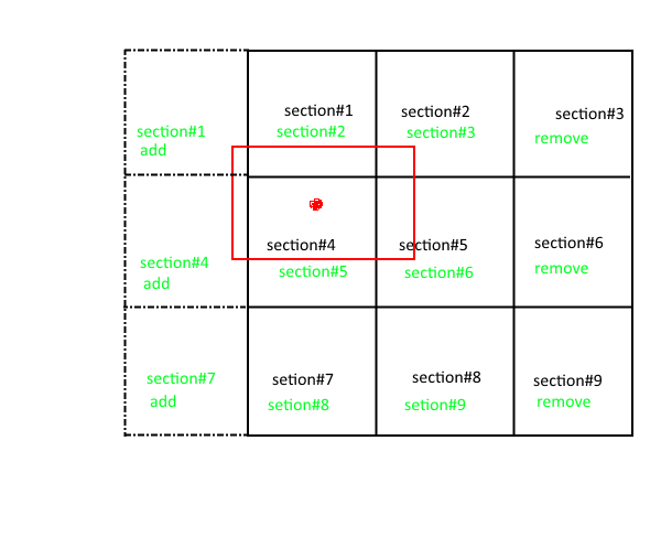
- Divide whole map in equal squares(or at least in sectors) that could be identified by unique index. Below is rough vizualizer for this.
 I could detect in which section user currently is (by checking map center coordinates) and make ajax call asking for markers in this section. Benefit would be that response could be cached(I am going with Varnish). Great thing about this is that when Europe sleeps and USA is awake most of USE section are cached. And vice verse.
 - After first batch of markers is recieved send 8 more request for section next to this. Below again is rough vizualizer.

- Set min zoom level so that user couldnt zoom out of all 9 section area. The idea behind this is that I dont want cliend device to handle to many markers so there will always be only markers that are in corresponding 9 sections. If user would want to navigate for example from USA to Belgium he would have to use geolocation input.
- Catch whenever the bounds of map window goes outside of 9 section and requestvisualizer for new markers. In this example map center was in section#5 but now it is in section#4. I request there more section, add those markers to map and remove markers from sections #3, #6 and #9.
 I am not 100% sure about this design, expecially about how to divide whole earth in section? Earth in spherical, map is 2D plane. Should I divide by lat, lng coords or use haversine?
I could detect in which section user currently is (by checking map centre coordinates) and make AJAX call asking for markers in this section. Benefit would be that response could be cached (I am going with Varnish). Great thing about this is that when Europe sleeps and USA is awake most of USE section are cached, and vice versa.
- After first batch of markers is received send 8 more request for section next to this. Below again is rough visualizer.
- Set min zoom level so that user couldn't zoom out of all 9 section area. The idea behind this is that I don't want client device to handle to many markers so there will always be only markers that are in corresponding 9 sections. If user would want to navigate for example from USA to Belgium he would have to use geolocation input.
- Catch whenever the bounds of map window goes outside of 9 section and request for new markers. In this example map centre was in section#5 but now it is in section#4. I request there more section, add those markers to map and remove markers from sections #3, #6 and #9.
I am not 100% sure about this design, especially about how to divide whole earth in section? Earth in spherical, map is 2D plane. Should I divide by lat, lng coords or use haversine?
I looked more into how Google mapMaps transfer spherical globe to plane and found this great example. It can be observed that the longitude lines are actually paralelparallel so I could introduce a constant step for longitude.
deltaLon = (360/P)*d, where:
deltaLon = step for longitude in degresdegrees
P - length of equator in km
d - size if section square we are aiming in km
Knowing the step we can easily calculate number of section in longitudionallongitudinal directions and get longitudionallongitudinal index from given longitude coordinate. This index can be sendedsent to server where we would create to longitude bounds and run MySQL query WHERE longitude>min_bound AND longitude<=max_bound
My question is what would be the mathematical expresionexpression for latitude step if we are aiming for section square size of d? (I dontdon't care about poles, for all I care we can simply forbid to add markers near to poles and start counting our latitude index from lets say +/-80 degrees)
