Add comment
Source Link
Ernesto561
  • 661
  • 8
  • 17

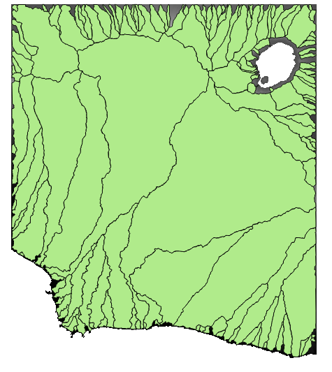
The closest I got to what I want was with the Channel Network and Drainage Basins tool, although there are still small details in the areas close to the coast. In this tool the input it's just a Filled DEM and the Stralehr order to begin a channel. It's based on the D8 method. I couldn't delineate subbasins.This is the result with a threshold of 5:

enter image description here.

The watersheds delineated with the Fill Sinks (Wang & Liu) still seem more like the expected result, but couldn't find anything about how the method works.

I won't mark this answer as accepted, because I couldn't solve my problem completely.

The closest I got to what I want was with the Channel Network and Drainage Basins tool, although there are still small details in the areas close to the coast. In this tool the input it's just a Filled DEM and the Stralehr order to begin a channel. It's based on the D8 method. I couldn't delineate subbasins.This is the result with a threshold of 5:

enter image description here.

The watersheds delineated with the Fill Sinks (Wang & Liu) still seem more like the expected result, but couldn't find anything about how the method works.

I won't mark this answer as accepted, because I couldn't solve my problem completely.
corrected spelling
Source Link
Ernesto561
  • 661
  • 8
  • 17

The closest I got to what I want was with the Channel Network and Drainage Basins tool, although there are still small details in the areas close to the coast. In this tool the input it's just a Filled DEM and the Stralehr order to begin a channel. It's based on the D8 method. I couldn't delineate subbasins.This is the result Smithwith a threshold of 5:

enter image description here.

The watersheds delineated with the Fill Sinks (Wang & Liu) still seem more like the expected result, but couldn't find anything about how the method works.

The closest I got to what I want was with the Channel Network and Drainage Basins tool, although there are still small details in the areas close to the coast. In this tool the input it's just a Filled DEM and the Stralehr order to begin a channel. It's based on the D8 method. I couldn't delineate subbasins.This is the result Smith a threshold of 5:

enter image description here.

The watersheds delineated with the Fill Sinks (Wang & Liu) still seem more like the expected result, but couldn't find anything about how the method works.

The closest I got to what I want was with the Channel Network and Drainage Basins tool, although there are still small details in the areas close to the coast. In this tool the input it's just a Filled DEM and the Stralehr order to begin a channel. It's based on the D8 method. I couldn't delineate subbasins.This is the result with a threshold of 5:

enter image description here.

The watersheds delineated with the Fill Sinks (Wang & Liu) still seem more like the expected result, but couldn't find anything about how the method works.

added 23 characters in body
Source Link
Ernesto561
  • 661
  • 8
  • 17

The closest I got to what I want was with the Channel Network and Drainage Basins tool, although there are still small details in the areas close to the coast. In this tool the input it's just a Filled DEM and the Stralehr order to begin a channel. It's based on the D8 method. I couldn't delineate subbasins.This is the result Smith a threshold of 5:

enter image description here.

The watersheds delineated with the Fill Sinks (Wang & Liu) still seem more like the expected result, but couldn't find anything about how the method works.

The closest I got to what I want was with the Channel Network and Drainage Basins tool, although there are still small details in the areas close to the coast. In this tool the input it's just a Filled DEM and the Stralehr order to begin a channel. It's based on the D8 method. I couldn't delineate subbasins.This is the result:

enter image description here.

The watersheds delineated with the Fill Sinks (Wang & Liu) still seem more like the expected result, but couldn't find anything about how the method works.

The closest I got to what I want was with the Channel Network and Drainage Basins tool, although there are still small details in the areas close to the coast. In this tool the input it's just a Filled DEM and the Stralehr order to begin a channel. It's based on the D8 method. I couldn't delineate subbasins.This is the result Smith a threshold of 5:

enter image description here.

The watersheds delineated with the Fill Sinks (Wang & Liu) still seem more like the expected result, but couldn't find anything about how the method works.

Source Link
Ernesto561
  • 661
  • 8
  • 17
Loading