added 2 characters in body
Source Link
ahmadhanb
  • 41.4k
  • 5
  • 54
  • 109

I think you are using different projections. It looks like the CSV file is in WGS 84 and and the grid is in WGS 84 / Pseudo Mercator projection. In order to have the points in polygonPoints in polygon tool works well you need to unify the projections into one projection. In other words, you need to change the projection of one of them into the other.

If you want to use WGS 84, then you need to right-click the grid shapefile -> Save as -> CRS and select the WGS 84:

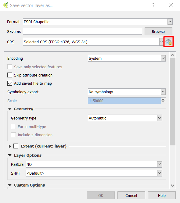
enter image description here

I think you are using different projections. It looks like the CSV file is in WGS 84 and and the grid is in WGS 84 / Pseudo Mercator projection. In order to have the points in polygon tool works well you need to unify the projections into one projection. In other words, you need to change the projection of one of them into the other.

If you want to use WGS 84, then you need to right-click the grid shapefile -> Save as -> CRS and select the WGS 84:

enter image description here

I think you are using different projections. It looks like the CSV file is in WGS 84 and and the grid is in WGS 84 / Pseudo Mercator projection. In order to have the Points in polygon tool works well you need to unify the projections into one projection. In other words, you need to change the projection of one of them into the other.

If you want to use WGS 84, then you need to right-click the grid shapefile -> Save as -> CRS and select the WGS 84:

enter image description here

Source Link
ahmadhanb
  • 41.4k
  • 5
  • 54
  • 109

I think you are using different projections. It looks like the CSV file is in WGS 84 and and the grid is in WGS 84 / Pseudo Mercator projection. In order to have the points in polygon tool works well you need to unify the projections into one projection. In other words, you need to change the projection of one of them into the other.

If you want to use WGS 84, then you need to right-click the grid shapefile -> Save as -> CRS and select the WGS 84:

enter image description here