Commonmark migration
Source Link

QGIS doesn't like you trying to join polygon to polygon this way. It doesn't know what to do with the geometry (QgsFeature.setGeometry(QgsGeometry): argument 1 has unexpected type 'NoneType'). It would better work with a mix point/polygon.

You rather need some Union tool if you want to keep all of the input geometry (below A area, plus A x B overlay area, plus B area). You will then have some data in the attribute table, that you can use afterwards in Excel.

  • Make sure each rollout area has a unique id, each postcode area its unique postcode code.
  • Do the Union, then update an area field.
  • Then export to Excel.
  • With a pivot table, you'll have your info.
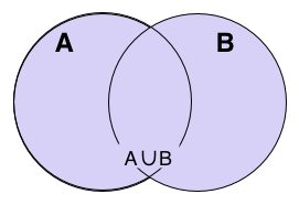
Union

#Union#

Union

##Description##

Description

This algorithm combines the feature(s) of both layers. Features that lie partially within the other layer’s features will be split. Areas that lie within both layers will be added as new features. If any features are selected in either of the layers, then only those features are used in the operation. If no features are selected then the operation is performed using all features.

##Parameters##

Parameters

  • Input layer [vector: any] : One layer containing feature(s) to be unioned.
  • Input layer 2 : [vector: any] : Second layer containing feature(s) to be unioned.

##Outputs##

Outputs

  • Union [vector] : Where to save the union layer. Can be saved to file, a temporary file or a memory layer.

Nb : If you only need A x B area, you'd rather need to look out at the Intersect tool

QGIS doesn't like you trying to join polygon to polygon this way. It doesn't know what to do with the geometry (QgsFeature.setGeometry(QgsGeometry): argument 1 has unexpected type 'NoneType'). It would better work with a mix point/polygon.

You rather need some Union tool if you want to keep all of the input geometry (below A area, plus A x B overlay area, plus B area). You will then have some data in the attribute table, that you can use afterwards in Excel.

  • Make sure each rollout area has a unique id, each postcode area its unique postcode code.
  • Do the Union, then update an area field.
  • Then export to Excel.
  • With a pivot table, you'll have your info.

Union

#Union#

##Description##

This algorithm combines the feature(s) of both layers. Features that lie partially within the other layer’s features will be split. Areas that lie within both layers will be added as new features. If any features are selected in either of the layers, then only those features are used in the operation. If no features are selected then the operation is performed using all features.

##Parameters##

  • Input layer [vector: any] : One layer containing feature(s) to be unioned.
  • Input layer 2 : [vector: any] : Second layer containing feature(s) to be unioned.

##Outputs##

  • Union [vector] : Where to save the union layer. Can be saved to file, a temporary file or a memory layer.

Nb : If you only need A x B area, you'd rather need to look out at the Intersect tool

QGIS doesn't like you trying to join polygon to polygon this way. It doesn't know what to do with the geometry (QgsFeature.setGeometry(QgsGeometry): argument 1 has unexpected type 'NoneType'). It would better work with a mix point/polygon.

You rather need some Union tool if you want to keep all of the input geometry (below A area, plus A x B overlay area, plus B area). You will then have some data in the attribute table, that you can use afterwards in Excel.

  • Make sure each rollout area has a unique id, each postcode area its unique postcode code.
  • Do the Union, then update an area field.
  • Then export to Excel.
  • With a pivot table, you'll have your info.

Union

Union

Description

This algorithm combines the feature(s) of both layers. Features that lie partially within the other layer’s features will be split. Areas that lie within both layers will be added as new features. If any features are selected in either of the layers, then only those features are used in the operation. If no features are selected then the operation is performed using all features.

Parameters

  • Input layer [vector: any] : One layer containing feature(s) to be unioned.
  • Input layer 2 : [vector: any] : Second layer containing feature(s) to be unioned.

Outputs

  • Union [vector] : Where to save the union layer. Can be saved to file, a temporary file or a memory layer.

Nb : If you only need A x B area, you'd rather need to look out at the Intersect tool

added 2 characters in body
Source Link
gisnside
  • 7.9k
  • 2
  • 32
  • 74

QGIS doesn't like you trying to join polygon to polygon this way. It doesn't know what to do with the geometry (QgsFeature.setGeometry(QgsGeometry): argument 1 has unexpected type 'NoneType'). It would better work with a mix point/polygon.

You rather need some Union tool if you want to keep all of the input geometry (below A area, plus A x B overlay area, plus B area). You will then have some data in the attribute table, that you can use afterwards in Excel.

  • Make sure each rollout area has a unique id, each postcode area its unique postcode code.
  • Do the Union, then update aan area field,.
  • Then export to Excel.
  • With a pivot table, you'll have youyour info.

Union

#Union#

##Description##

This algorithm combines the feature(s) of both layers. Features that lie partially within the other layer’s features will be split. Areas that lie within both layers will be added as new features. If any features are selected in either of the layers, then only those features are used in the operation. If no features are selected then the operation is performed using all features.

##Parameters##

  • Input layer [vector: any] : One layer containing feature(s) to be unioned.
  • Input layer 2 : [vector: any] : Second layer containing feature(s) to be unioned.

##Outputs##

  • Union [vector] : Where to save the union layer. Can be saved to file, a temporary file or a memory layer.

Nb : If you only need A x B area, you'd rather need to look out at the Intersect tool

QGIS doesn't like you trying to join polygon to polygon this way. It doesn't know what to do with the geometry (QgsFeature.setGeometry(QgsGeometry): argument 1 has unexpected type 'NoneType'). It would better work with a mix point/polygon.

You rather need some Union tool if you want to keep all of the input geometry (below A area, plus A x B overlay area, plus B area). You will then have some data in the attribute table, that you can use afterwards in Excel.

  • Make sure each rollout area has a unique id, each postcode area its unique postcode code.
  • Do the Union, then update a area field,
  • Then export to Excel.
  • With a pivot table, you'll have you info.

Union

#Union#

##Description##

This algorithm combines the feature(s) of both layers. Features that lie partially within the other layer’s features will be split. Areas that lie within both layers will be added as new features. If any features are selected in either of the layers, then only those features are used in the operation. If no features are selected then the operation is performed using all features.

##Parameters##

  • Input layer [vector: any] : One layer containing feature(s) to be unioned.
  • Input layer 2 : [vector: any] : Second layer containing feature(s) to be unioned.

##Outputs##

  • Union [vector] : Where to save the union layer. Can be saved to file, a temporary file or a memory layer.

Nb : If you only need A x B area, you'd rather need to look out at the Intersect tool

QGIS doesn't like you trying to join polygon to polygon this way. It doesn't know what to do with the geometry (QgsFeature.setGeometry(QgsGeometry): argument 1 has unexpected type 'NoneType'). It would better work with a mix point/polygon.

You rather need some Union tool if you want to keep all of the input geometry (below A area, plus A x B overlay area, plus B area). You will then have some data in the attribute table, that you can use afterwards in Excel.

  • Make sure each rollout area has a unique id, each postcode area its unique postcode code.
  • Do the Union, then update an area field.
  • Then export to Excel.
  • With a pivot table, you'll have your info.

Union

#Union#

##Description##

This algorithm combines the feature(s) of both layers. Features that lie partially within the other layer’s features will be split. Areas that lie within both layers will be added as new features. If any features are selected in either of the layers, then only those features are used in the operation. If no features are selected then the operation is performed using all features.

##Parameters##

  • Input layer [vector: any] : One layer containing feature(s) to be unioned.
  • Input layer 2 : [vector: any] : Second layer containing feature(s) to be unioned.

##Outputs##

  • Union [vector] : Where to save the union layer. Can be saved to file, a temporary file or a memory layer.

Nb : If you only need A x B area, you'd rather need to look out at the Intersect tool

added 2 characters in body
Source Link
gisnside
  • 7.9k
  • 2
  • 32
  • 74

QGIS doesn't like you trying to join polygon to polygon this way. It doesn't know what to do with the geometry (QgsFeature.setGeometry(QgsGeometry): argument 1 has unexpected type 'NoneType'QgsFeature.setGeometry(QgsGeometry): argument 1 has unexpected type 'NoneType'). It would better work with a mix point/polygon.

You rather need some Union tool if you want to keep all of the input geometry (below A area, plus A x B overlay area, plus B area)?. You will then have some data in the attribute table, that you can use afterwards in Excel.

  • Make sure each rollout area has a unique id, each postcode area its unique postcode code.
  • Do the Union, then update a area field,
  • Then export to Excel.
  • With a pivot table, you'll have you info.

Union

#Union#

##Description##

This algorithm combines the feature(s) of both layers. Features that lie partially within the other layer’s features will be split. Areas that lie within both layers will be added as new features. If any features are selected in either of the layers, then only those features are used in the operation. If no features are selected then the operation is performed using all features.

##Parameters##

  • Input layer [vector: any] : One layer containing feature(s) to be unioned.
  • Input layer 2 : [vector: any] : Second layer containing feature(s) to be unioned.

##Outputs##

  • Union [vector] : Where to save the union layer. Can be saved to file, a temporary file or a memory layer.

Nb : If you only need A x B area, you'd rather need to look out at the Intersect tool

QGIS doesn't like you trying to join polygon to polygon this way. It doesn't know what to do with the geometry (QgsFeature.setGeometry(QgsGeometry): argument 1 has unexpected type 'NoneType'). It would better work with a mix point/polygon.

You rather need some Union tool if you want to keep all of the input geometry (below A area, plus A x B area, plus B area)?

Union

#Union#

##Description##

This algorithm combines the feature(s) of both layers. Features that lie partially within the other layer’s features will be split. Areas that lie within both layers will be added as new features. If any features are selected in either of the layers, then only those features are used in the operation. If no features are selected then the operation is performed using all features.

##Parameters##

  • Input layer [vector: any] : One layer containing feature(s) to be unioned.
  • Input layer 2 : [vector: any] : Second layer containing feature(s) to be unioned.

##Outputs##

  • Union [vector] : Where to save the union layer. Can be saved to file, a temporary file or a memory layer.

Nb : If you only need A x B area, you'd rather need to look out at the Intersect tool

QGIS doesn't like you trying to join polygon to polygon this way. It doesn't know what to do with the geometry (QgsFeature.setGeometry(QgsGeometry): argument 1 has unexpected type 'NoneType'). It would better work with a mix point/polygon.

You rather need some Union tool if you want to keep all of the input geometry (below A area, plus A x B overlay area, plus B area). You will then have some data in the attribute table, that you can use afterwards in Excel.

  • Make sure each rollout area has a unique id, each postcode area its unique postcode code.
  • Do the Union, then update a area field,
  • Then export to Excel.
  • With a pivot table, you'll have you info.

Union

#Union#

##Description##

This algorithm combines the feature(s) of both layers. Features that lie partially within the other layer’s features will be split. Areas that lie within both layers will be added as new features. If any features are selected in either of the layers, then only those features are used in the operation. If no features are selected then the operation is performed using all features.

##Parameters##

  • Input layer [vector: any] : One layer containing feature(s) to be unioned.
  • Input layer 2 : [vector: any] : Second layer containing feature(s) to be unioned.

##Outputs##

  • Union [vector] : Where to save the union layer. Can be saved to file, a temporary file or a memory layer.

Nb : If you only need A x B area, you'd rather need to look out at the Intersect tool

Source Link
gisnside
  • 7.9k
  • 2
  • 32
  • 74
Loading