Tweeted twitter.com/StackGIS/status/983092995728736256
edited question; give exact configuration
Source Link
Markus
  • 221
  • 2
  • 6

I have different layers with different CRS, I think therefore the layers don't match. But I don't know how to fix this. Here is what I did (QGIS 3.0.1 on Debian Buster).

I connected to OpenStreetMap Tile Server https://a.tile.openstreetmap.org/{z}/{x}/{y}.png to request XYZ Tiles. This is the first layer.

The tile server uses the CRS WGS 84, Pseudo Mercator Projection EPSG 3857.

Now, I tried to built my own map, by doing a quick query with QuickOSM. Key is building, querying Extent of the map canvas (coordinates are 300.000, 6.100.000, Scale is 1:60.000, which is in France, somewhere south of Paris).

This gives me three additional layers, all called OsmQuery, see image.

enter image description here

The additional layers use CRS WGS 84 EPSG:4326. If you look at the map, you see the buildings belonging to Chateau-Landon (south) near La Madeleine-sur-Loing (north). The destinations are about 7km apart.

My thinking is: "The error might result from different projections. However, 7km is a lot. I find it kind of strange that OpenStreetMap uses two different CRS." But I'm quite a newbie...

What can I do to get an exact match of all the layers?

First try:

I did change "Project CRS" to EPSG: 4326 as suggested by JoshC's comment, resulting in a slight change of perspective of the main window, but the distance of 7km stays pretty much the same.

Additionally, JoshC suggested to turn on "On the fly projection", but: "Disabling on the fly projection is no longer an option in My QGIS 3.0" (issues.qgis.org/issues/11644)

2nd try

I also tried "Reproject layer" from Processing Toolbox: enter image description here
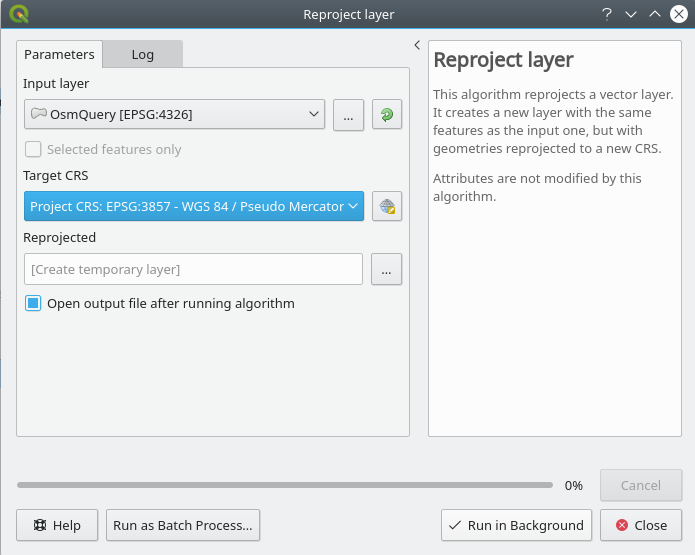
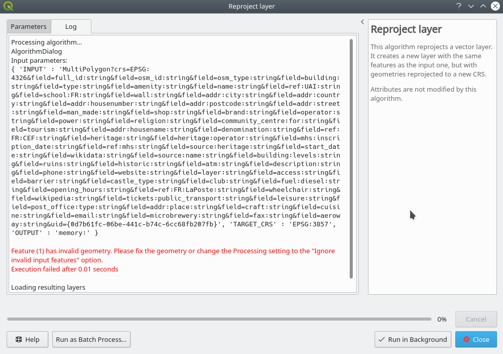
If I click "Run in Background", I get the following error: enter image description here
3rd try

In the layers panel, I right-clicked on one of the EPSG:4326 layers and chose "Save as..." and saved itversion is as EPSGfollows:3857 layer and displayed that. It was identical to its original position, so NOT where I would have wanted it, i.e. 7km more to the south.

I think this is quite a common usage (described e.g. in https://docs.qgis.org/testing/en/docs/training_manual/foreword/preparing_data.html#hard-ty), so there must be some simple solution...enter image description here

I have different layers with different CRS, I think therefore the layers don't match. But I don't know how to fix this. Here is what I did (QGIS 3.0.1 on Debian Buster).

I connected to OpenStreetMap Tile Server https://a.tile.openstreetmap.org/{z}/{x}/{y}.png to request XYZ Tiles. This is the first layer.

The tile server uses the CRS WGS 84, Pseudo Mercator Projection EPSG 3857.

Now, I tried to built my own map, by doing a quick query with QuickOSM. Key is building, querying Extent of the map canvas (coordinates are 300.000, 6.100.000, Scale is 1:60.000, which is in France, somewhere south of Paris).

This gives me three additional layers, all called OsmQuery, see image.

enter image description here

The additional layers use CRS WGS 84 EPSG:4326. If you look at the map, you see the buildings belonging to Chateau-Landon (south) near La Madeleine-sur-Loing (north). The destinations are about 7km apart.

My thinking is: "The error might result from different projections. However, 7km is a lot. I find it kind of strange that OpenStreetMap uses two different CRS." But I'm quite a newbie...

What can I do to get an exact match of all the layers?

First try:

I did change "Project CRS" to EPSG: 4326 as suggested by JoshC's comment, resulting in a slight change of perspective of the main window, but the distance of 7km stays pretty much the same.

Additionally, JoshC suggested to turn on "On the fly projection", but: "Disabling on the fly projection is no longer an option in QGIS 3.0" (issues.qgis.org/issues/11644)

2nd try

I also tried "Reproject layer" from Processing Toolbox: enter image description here

If I click "Run in Background", I get the following error: enter image description here

3rd try

In the layers panel, I right-clicked on one of the EPSG:4326 layers and chose "Save as..." and saved it as EPSG:3857 layer and displayed that. It was identical to its original position, so NOT where I would have wanted it, i.e. 7km more to the south.

I think this is quite a common usage (described e.g. in https://docs.qgis.org/testing/en/docs/training_manual/foreword/preparing_data.html#hard-ty), so there must be some simple solution...

I have different layers with different CRS, I think therefore the layers don't match. But I don't know how to fix this. Here is what I did (QGIS 3.0.1 on Debian Buster).

I connected to OpenStreetMap Tile Server https://a.tile.openstreetmap.org/{z}/{x}/{y}.png to request XYZ Tiles. This is the first layer.

The tile server uses the CRS WGS 84, Pseudo Mercator Projection EPSG 3857.

Now, I tried to built my own map, by doing a quick query with QuickOSM. Key is building, querying Extent of the map canvas (coordinates are 300.000, 6.100.000, Scale is 1:60.000, which is in France, somewhere south of Paris).

This gives me three additional layers, all called OsmQuery, see image.

enter image description here

The additional layers use CRS WGS 84 EPSG:4326. If you look at the map, you see the buildings belonging to Chateau-Landon (south) near La Madeleine-sur-Loing (north). The destinations are about 7km apart.

My thinking is: "The error might result from different projections. However, 7km is a lot. I find it kind of strange that OpenStreetMap uses two different CRS." But I'm quite a newbie...

What can I do to get an exact match of all the layers?

My QGIS version is as follows:

enter image description here

corrected typos
Source Link
nmtoken
  • 13.6k
  • 5
  • 38
  • 89

openstreetmap OpenStreetMap: CRS not matching

I have different layers with different CRS, I think therefore the layers don't match. But I don't know how to fix this. Here is what I did (GQisQGIS 3.0.1 on Debian Buster).

I connected to OpenStreetMap Tile Server https://a.tile.openstreetmap.org/{z}/{x}/{y}.png to request XYZ Tiles. This is the first layer.

The tile server uses the CRS WGS 84, Pseudo Mercator Projection EPSG 3857.

Now, I tried to built my own map, by doing a quick query with QuickOSM. Key is building, querying Extent of the map canvas (coordinates are 300.000, 6.100.000, Scale is 1:60.000, which is in France, somewhere south of Paris).

This gives me 3three additional layers, all called OsmQuery, see image.

enter image description here

The additional layers use CRS WGS 84 EPSG:4326. If you look at the map, you see the buildings belonging to Chateau-Landon (south) near La Madeleine-sur-Loing (north). The destinations are about 7km apart.

My thinking is: "The error might result from different projections. However, 7km is a lot. I find it kind of strange that OpenStreetMap uses two different CRS." But I'm quite a newbie...

What can I do to get an exact match of all the layers?

First try:

I did change "Project CRS" to EPSG: 4326 as suggested by JoshC's comment, resulting in a slight change of perspective of the main window, but the distance of 7km stays pretty much the same.

Additionally, JoshC suggested to turn on "On the fly projection", but: "Disabling on the fly projection is no longer an option in QGIS 3.0" (issues.qgis.org/issues/11644)

2nd try

I also tried "Reproject layer" from Processing Toolbox: enter image description here

If I click "Run in Background", I get the following error: enter image description here

3rd try

In the layers panel, I right-clicked on one of the EPSG 4326:4326 layers and chose "Save as..." and saved it as EPSG: 38573857 layer and displayed that. It was identical to its original position, so NOT where I would have wanted it, i.e. 7km more to the south.

I think this is quite a common usage (described e.g. in https://docs.qgis.org/testing/en/docs/training_manual/foreword/preparing_data.html#hard-ty), so there must be some simple solution...

openstreetmap: CRS not matching

I have different layers with different CRS, I think therefore the layers don't match. But I don't know how to fix this. Here is what I did (GQis 3.0.1 on Debian Buster).

I connected to OpenStreetMap Tile Server https://a.tile.openstreetmap.org/{z}/{x}/{y}.png to request XYZ Tiles. This is the first layer.

The tile server uses the CRS WGS 84, Pseudo Mercator Projection EPSG 3857.

Now, I tried to built my own map, by doing a quick query with QuickOSM. Key is building, querying Extent of the map canvas (coordinates are 300.000, 6.100.000, Scale is 1:60.000, which is in France, somewhere south of Paris).

This gives me 3 additional layers, all called OsmQuery, see image.

enter image description here

The additional layers use CRS WGS 84 EPSG:4326. If you look at the map, you see the buildings belonging to Chateau-Landon (south) near La Madeleine-sur-Loing (north). The destinations are about 7km apart.

My thinking is: "The error might result from different projections. However, 7km is a lot. I find it kind of strange that OpenStreetMap uses two different CRS." But I'm quite a newbie...

What can I do to get an exact match of all the layers?

First try:

I did change "Project CRS" to EPSG: 4326 as suggested by JoshC's comment, resulting in a slight change of perspective of the main window, but the distance of 7km stays pretty much the same.

Additionally, JoshC suggested to turn on "On the fly projection", but: "Disabling on the fly projection is no longer an option in QGIS 3.0" (issues.qgis.org/issues/11644)

2nd try

I also tried "Reproject layer" from Processing Toolbox: enter image description here

If I click "Run in Background", I get the following error: enter image description here

3rd try

In the layers panel, I right-clicked on one of the EPSG 4326 layers and chose "Save as..." and saved it as EPSG: 3857 layer and displayed that. It was identical to its original position, so NOT where I would have wanted it, i.e. 7km more to the south.

I think this is quite a common usage (described e.g. in https://docs.qgis.org/testing/en/docs/training_manual/foreword/preparing_data.html#hard-ty), so there must be some simple solution...

OpenStreetMap: CRS not matching

I have different layers with different CRS, I think therefore the layers don't match. But I don't know how to fix this. Here is what I did (QGIS 3.0.1 on Debian Buster).

I connected to OpenStreetMap Tile Server https://a.tile.openstreetmap.org/{z}/{x}/{y}.png to request XYZ Tiles. This is the first layer.

The tile server uses the CRS WGS 84, Pseudo Mercator Projection EPSG 3857.

Now, I tried to built my own map, by doing a quick query with QuickOSM. Key is building, querying Extent of the map canvas (coordinates are 300.000, 6.100.000, Scale is 1:60.000, which is in France, somewhere south of Paris).

This gives me three additional layers, all called OsmQuery, see image.

enter image description here

The additional layers use CRS WGS 84 EPSG:4326. If you look at the map, you see the buildings belonging to Chateau-Landon (south) near La Madeleine-sur-Loing (north). The destinations are about 7km apart.

My thinking is: "The error might result from different projections. However, 7km is a lot. I find it kind of strange that OpenStreetMap uses two different CRS." But I'm quite a newbie...

What can I do to get an exact match of all the layers?

First try:

I did change "Project CRS" to EPSG: 4326 as suggested by JoshC's comment, resulting in a slight change of perspective of the main window, but the distance of 7km stays pretty much the same.

Additionally, JoshC suggested to turn on "On the fly projection", but: "Disabling on the fly projection is no longer an option in QGIS 3.0" (issues.qgis.org/issues/11644)

2nd try

I also tried "Reproject layer" from Processing Toolbox: enter image description here

If I click "Run in Background", I get the following error: enter image description here

3rd try

In the layers panel, I right-clicked on one of the EPSG:4326 layers and chose "Save as..." and saved it as EPSG:3857 layer and displayed that. It was identical to its original position, so NOT where I would have wanted it, i.e. 7km more to the south.

I think this is quite a common usage (described e.g. in https://docs.qgis.org/testing/en/docs/training_manual/foreword/preparing_data.html#hard-ty), so there must be some simple solution...

another try
Source Link
Markus
  • 221
  • 2
  • 6
Loading
various edits
Source Link
Markus
  • 221
  • 2
  • 6
Loading
added 187 characters in body
Source Link
Markus
  • 221
  • 2
  • 6
Loading
describing new problems when following JoshC's comment
Source Link
Markus
  • 221
  • 2
  • 6
Loading
Source Link
Markus
  • 221
  • 2
  • 6
Loading