UPDATE
Source Link

You can do that like here:

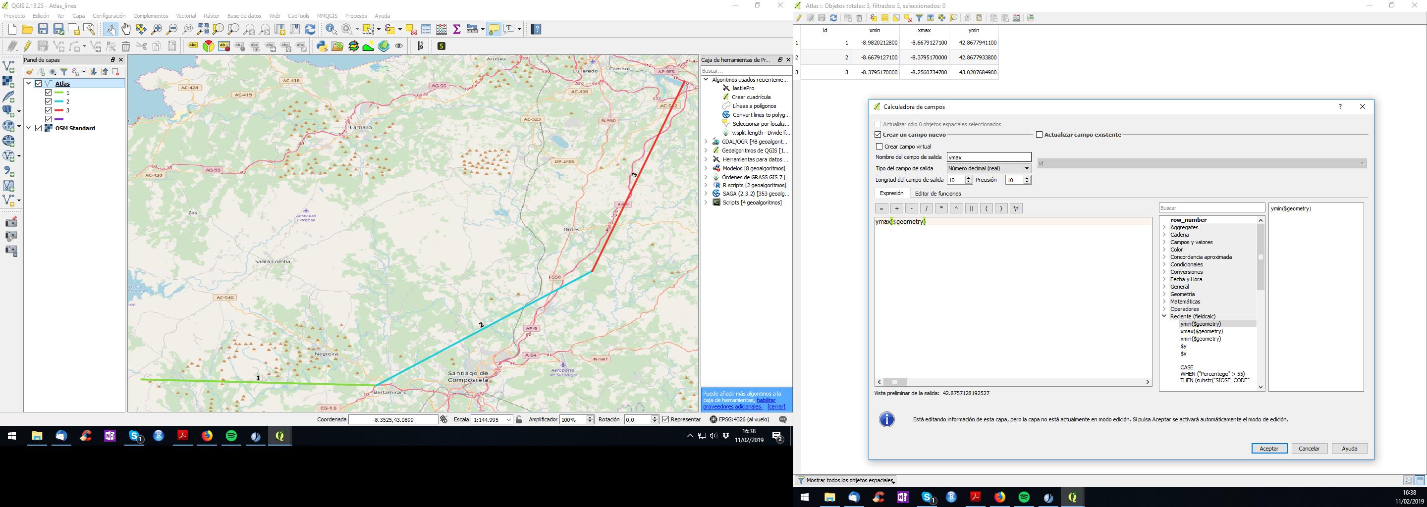
  1. Add xmin/xmax/ymin/ymax to each feature of your atlas layer. Your can do it with the function:

xmax($geometry)

enter image description here

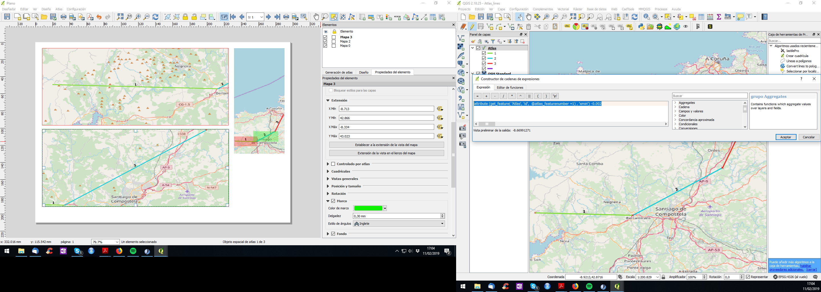
  1. Control your atlas by extentension, defining a functions inside thouse xmin/xmax/ymin/ymax in composer (here, as you can figure it out, that -0.002 creates an small margin around the feature):

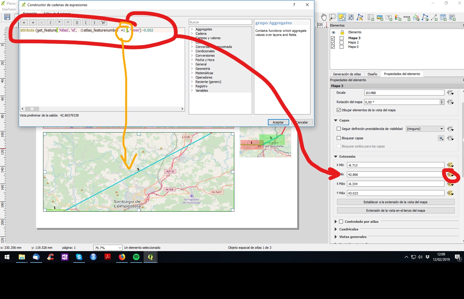
attribute (get_feature( 'Atlas', 'id', @atlas_featurenumber +1) , 'xmin') -0.002

enter image description here

If you use this system don't mark "controlled by atlas".

Be creative and you will get a perfect atlas.

Edit:

HOW TO EDIT EXTENSION BY ATRIBUTE IN COMPOSER

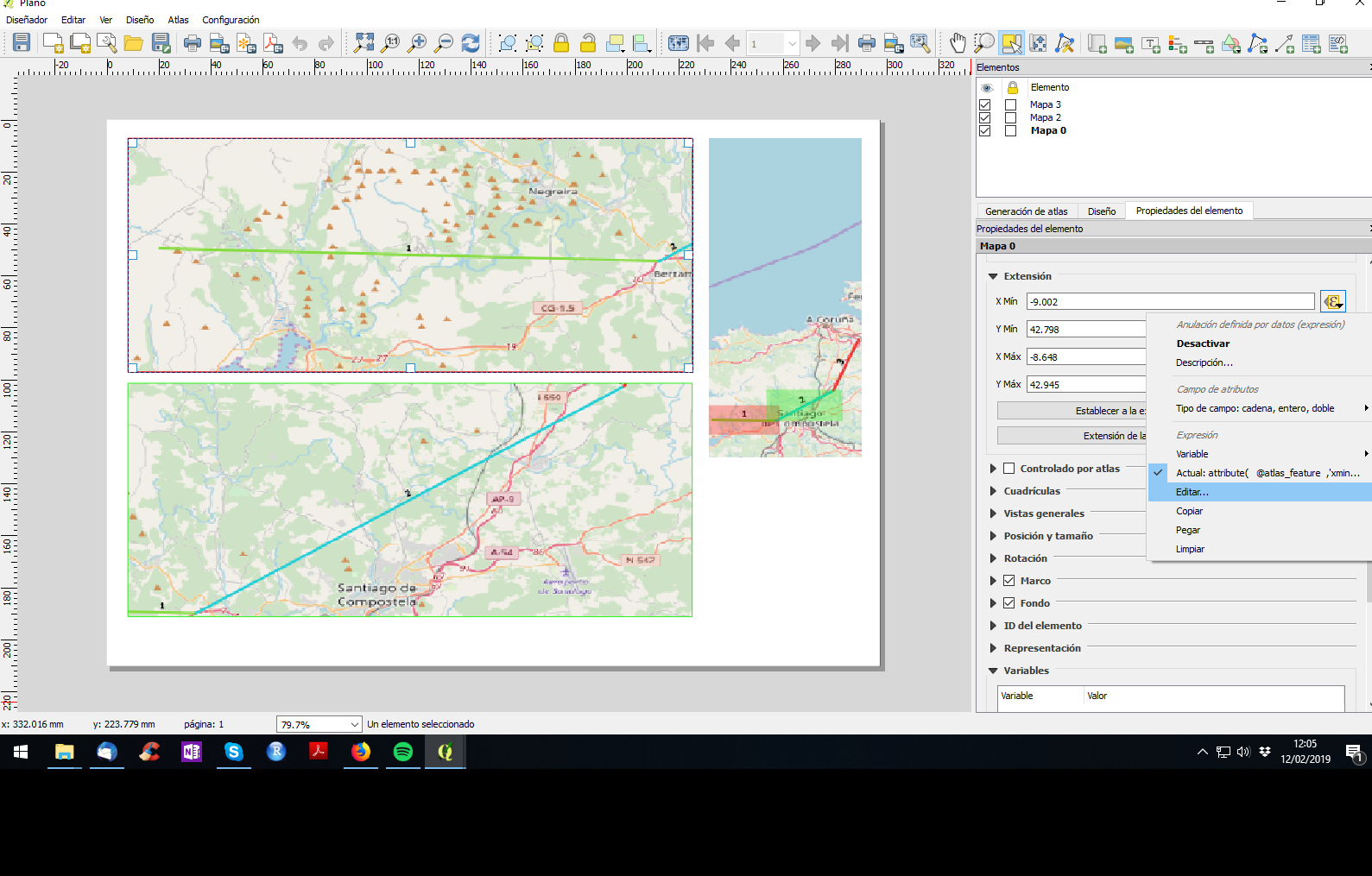
Select the square of map --> properties --> extension --> xmin/xmax/ymin/ymax: edit... (sorry, my QGIS is in spanish, but can get the position):

enter image description here

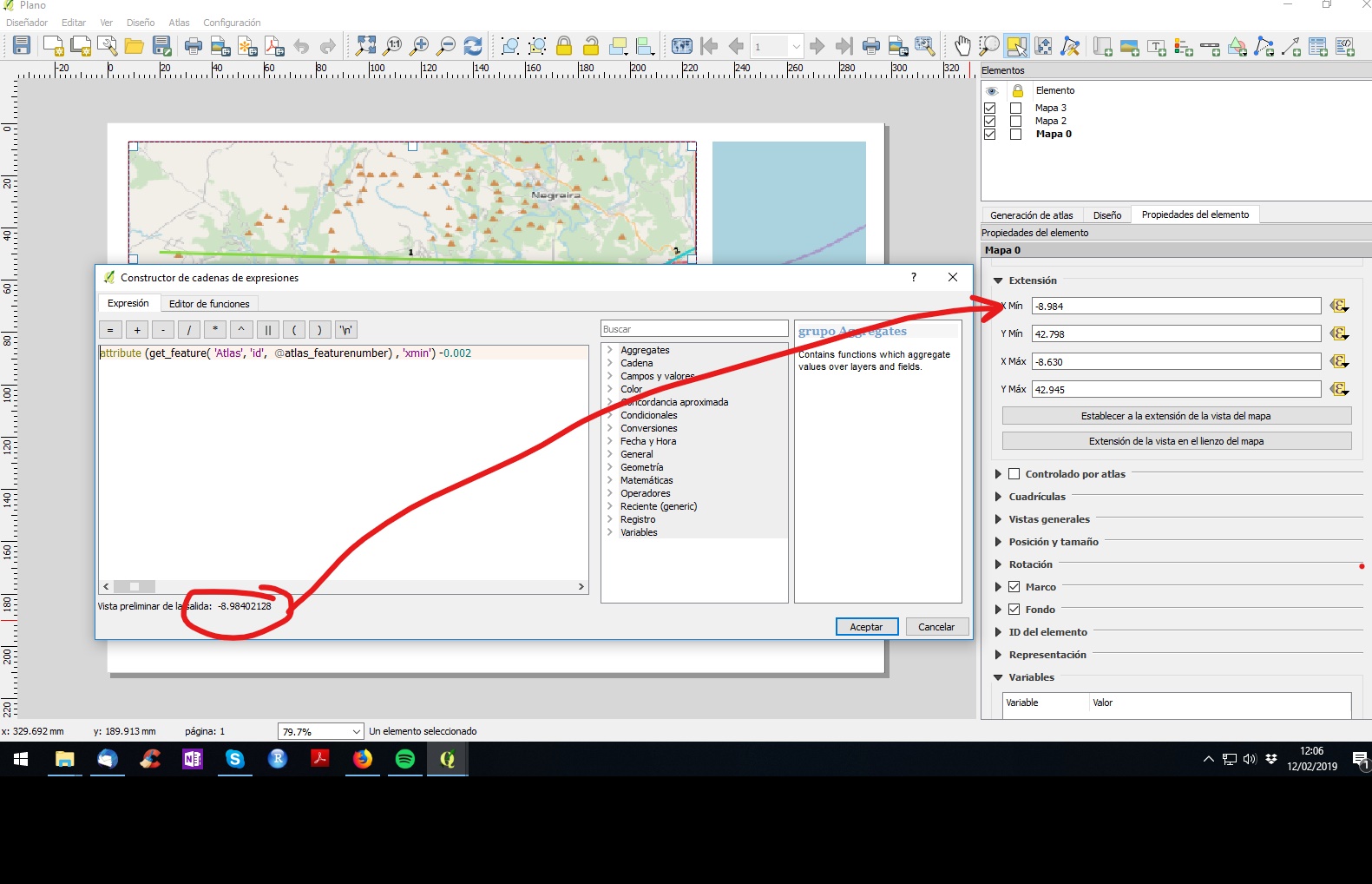
If you write the function properly you will get the xmin/xmax/ymin/ymax value of the desired feature of your atlas:

enter image description here

Same for each xy of square 2: Here "+1" means "go to the following feature from your atlas layer". Do the same for each xmin/xmax/ymin/ymax and adapt the function.

enter image description here

Update to avoid repeated features:

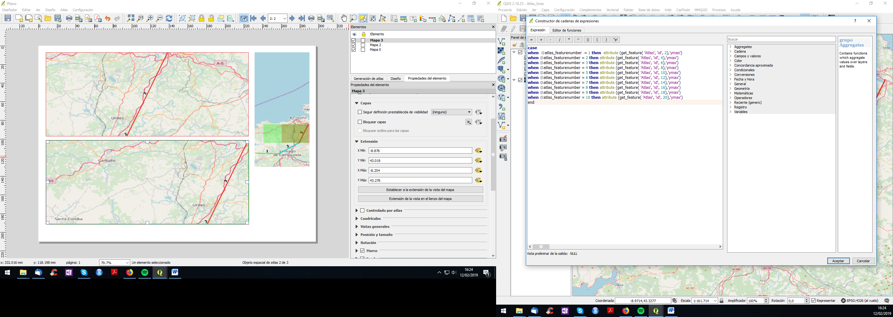
Here is the code for the upper map xmin:

case
when @atlas_featurenumber = 1 then  attribute (get_feature( 'Atlas', 'id', 1),'xmin')
when @atlas_featurenumber = 2 then attribute (get_feature( 'Atlas', 'id', 3),'xmin')
when @atlas_featurenumber = 3 then attribute (get_feature( 'Atlas', 'id', 5),'xmin')
when @atlas_featurenumber = 4 then attribute (get_feature( 'Atlas', 'id', 7),'xmin')
when @atlas_featurenumber = 5 then attribute (get_feature( 'Atlas', 'id', 9),'xmin')
when @atlas_featurenumber = 6 then attribute (get_feature( 'Atlas', 'id', 11),'xmin')
when @atlas_featurenumber = 7 then attribute (get_feature( 'Atlas', 'id', 13),'xmin')
when @atlas_featurenumber = 8 then attribute (get_feature( 'Atlas', 'id', 15),'xmin')
when @atlas_featurenumber = 9 then attribute (get_feature( 'Atlas', 'id', 17),'xmin')
when @atlas_featurenumber = 10 then attribute (get_feature( 'Atlas', 'id', 19),'xmin')
end

This code allows you to go from feature 1 to 3 to 5... in the upper square. Do the same for xmax/ymin/ymax. Then copy the code, go to lower map and paste it replacing those 1,3,5... by 2,4,6... As you may have noticed this code allows you to create a consequent map with 10 pages as much. If it has more page, you just need to add lines with the same logic. enter image description here
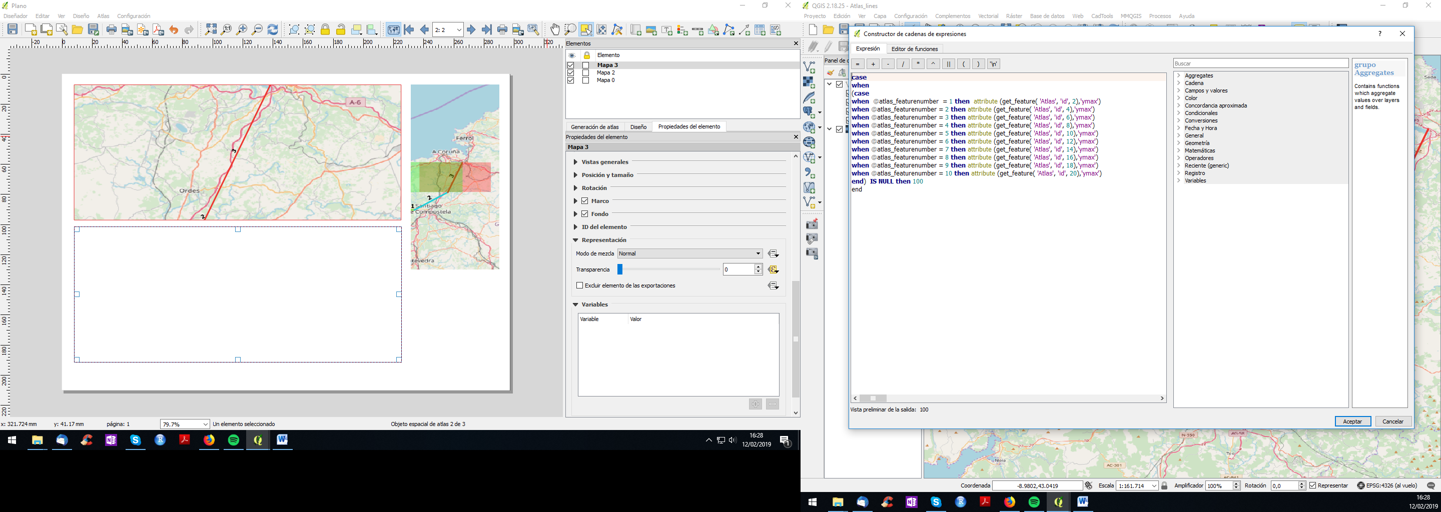
And if you have odd number of segments you can make invisible the lower map by, also, adding a function to make it transparent like (when Atlas feature is null then make it 100% transparent): enter image description here
You can do that like here:

  1. Add xmin/xmax/ymin/ymax to each feature of your atlas layer. Your can do it with the function:

xmax($geometry)

enter image description here

  1. Control your atlas by extentension, defining a functions inside thouse xmin/xmax/ymin/ymax in composer (here, as you can figure it out, that -0.002 creates an small margin around the feature):

attribute (get_feature( 'Atlas', 'id', @atlas_featurenumber +1) , 'xmin') -0.002

enter image description here

If you use this system don't mark "controlled by atlas".

Be creative and you will get a perfect atlas.

Edit:

HOW TO EDIT EXTENSION BY ATRIBUTE IN COMPOSER

Select the square of map --> properties --> extension --> xmin/xmax/ymin/ymax: edit... (sorry, my QGIS is in spanish, but can get the position):

enter image description here

If you write the function properly you will get the xmin/xmax/ymin/ymax value of the desired feature of your atlas:

enter image description here

Same for each xy of square 2: Here "+1" means "go to the following feature from your atlas layer". Do the same for each xmin/xmax/ymin/ymax and adapt the function.

enter image description here

Update to avoid repeated features:

Here is the code for the upper map xmin:

case
when @atlas_featurenumber = 1 then  attribute (get_feature( 'Atlas', 'id', 1),'xmin')
when @atlas_featurenumber = 2 then attribute (get_feature( 'Atlas', 'id', 3),'xmin')
when @atlas_featurenumber = 3 then attribute (get_feature( 'Atlas', 'id', 5),'xmin')
when @atlas_featurenumber = 4 then attribute (get_feature( 'Atlas', 'id', 7),'xmin')
when @atlas_featurenumber = 5 then attribute (get_feature( 'Atlas', 'id', 9),'xmin')
when @atlas_featurenumber = 6 then attribute (get_feature( 'Atlas', 'id', 11),'xmin')
when @atlas_featurenumber = 7 then attribute (get_feature( 'Atlas', 'id', 13),'xmin')
when @atlas_featurenumber = 8 then attribute (get_feature( 'Atlas', 'id', 15),'xmin')
when @atlas_featurenumber = 9 then attribute (get_feature( 'Atlas', 'id', 17),'xmin')
when @atlas_featurenumber = 10 then attribute (get_feature( 'Atlas', 'id', 19),'xmin')
end

This code allows you to go from feature 1 to 3 to 5... in the upper square. Do the same for xmax/ymin/ymax. Then copy the code, go to lower map and paste it replacing those 1,3,5... by 2,4,6... As you may have noticed this code allows you to create a consequent map with 10 pages as much. If it has more page, you just need to add lines with the same logic. enter image description here

And if you have odd number of segments you can make invisible the lower map by, also, adding a function to make it transparent like (when Atlas feature is null then make it 100% transparent): enter image description here

added 754 characters in body
Source Link

You can do that like here:

  1. Add xmin/xmax/ymin/ymax to each feature of your atlas layer. Your can do it with the function:

xmax($geometry)

enter image description here

  1. Control your atlas by extentension, defining a functions inside thouse xmin/xmax/ymin/ymax in composer (here, as you can figure it out, that -0.002 creates an small margin around the feature):

attribute (get_feature( 'Atlas', 'id', @atlas_featurenumber +1) , 'xmin') -0.002

enter image description here

If you use this system don't mark "controlled by atlas".

Be creative and you will get a perfect atlas.

Edit:

HOW TO EDIT EXTENSION BY ATRIBUTE IN COMPOSER

Select the square of map --> properties --> extension --> xmin/xmax/ymin/ymax: edit... (sorry, my QGIS is in spanish, but can get the position):

enter image description here

If you write the function properly you will get the xmin/xmax/ymin/ymax value of the desired feature of your atlas:

enter image description here

Same for each xy of square 2: Here "+1" means "go to the following feature from your atlas layer". Do the same for each xmin/xmax/ymin/ymax and adapt the function.

enter image description here

You can do that like here:

  1. Add xmin/xmax/ymin/ymax to each feature of your atlas layer. Your can do it with the function:

xmax($geometry)

enter image description here

  1. Control your atlas by extentension, defining a functions inside thouse xmin/xmax/ymin/ymax in composer (here, as you can figure it out, that -0.002 creates an small margin around the feature):

attribute (get_feature( 'Atlas', 'id', @atlas_featurenumber +1) , 'xmin') -0.002

enter image description here

If you use this system don't mark "controlled by atlas".

Be creative and you will get a perfect atlas.

Edit:

HOW TO EDIT EXTENSION BY ATRIBUTE IN COMPOSER

Select the square of map --> properties --> extension --> xmin/xmax/ymin/ymax: edit... (sorry, my QGIS is in spanish, but can get the position):

enter image description here

If you write the function properly you will get the xmin/xmax/ymin/ymax value of the desired feature of your atlas:

enter image description here

Same for each xy of square 2: Here "+1" means "go to the following feature from your atlas layer". Do the same for each xmin/xmax/ymin/ymax and adapt the function.

enter image description here

added 6 characters in body
Source Link

You can do that like here:

  1. Add xmin/xmax/ymin/ymax to each feature of your atlas layer. Your can do it with the function: xmax($geometry) enter image description here
  2. Control your atlas by extentension, defining a functions inside thouse xmin/xmax/ymin/ymax in composer (here, as you can figure it out, that -0.002 creates an small margin around the feature):

xmax($geometry)

enter image description here

  1. Control your atlas by extentension, defining a functions inside thouse xmin/xmax/ymin/ymax in composer (here, as you can figure it out, that -0.002 creates an small margin around the feature):

attribute (get_feature( 'Atlas', 'id', @atlas_featurenumber +1) , 'xmin') -0.002

enter image description here

If you use this system don't mark "controlled by atlas".

Be creative and you will get a perfect atlas.

You can do that like here:

  1. Add xmin/xmax/ymin/ymax to each feature of your atlas layer. Your can do it with the function: xmax($geometry) enter image description here
  2. Control your atlas by extentension, defining a functions inside thouse xmin/xmax/ymin/ymax in composer (here, as you can figure it out, that -0.002 creates an small margin around the feature):

attribute (get_feature( 'Atlas', 'id', @atlas_featurenumber +1) , 'xmin') -0.002

enter image description here

If you use this system don't mark "controlled by atlas".

Be creative and you will get a perfect atlas.

You can do that like here:

  1. Add xmin/xmax/ymin/ymax to each feature of your atlas layer. Your can do it with the function:

xmax($geometry)

enter image description here

  1. Control your atlas by extentension, defining a functions inside thouse xmin/xmax/ymin/ymax in composer (here, as you can figure it out, that -0.002 creates an small margin around the feature):

attribute (get_feature( 'Atlas', 'id', @atlas_featurenumber +1) , 'xmin') -0.002

enter image description here

If you use this system don't mark "controlled by atlas".

Be creative and you will get a perfect atlas.

added 89 characters in body
Source Link
Loading
Source Link
Loading