Title changed, Content structured, Two tags added
Source Link
Taras
  • 34k
  • 4
  • 73
  • 148

When using QGIS join by location, how How does QGIS determine the first located feature option when using QGIS Join by location?

I have used QGIS process 'join attributes by location''Join Attributes by Location' in one of the models I have built and I have now been asked to explain in detail exactly how the model is determining the results.

I am using it to fill in spaces in the data by joining by location using the touching option with 0.1 precision and taking attributes of the first located feature.

I have tried making mock squares and applying the same principles to determine what way QGIS picks the first located feature but I have been unsuccessful in determining how exactly it is doing it.

I have considered N-S, E-W and also the order of which the Data being transferring has been created but none of them seems to explain how it chooses the feature.

I have looked for answers to this online and in the QGIS website but have found no explanation   

enter image description here

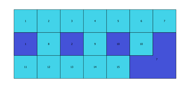
Above is a sample of what results when trying this technique. The light blue are the original polygons with their creation order attached in the attribute table and the purple is the number that joins when testing join by location to assign a number to the blank purple polygons from the light blue ones.

Does anyone know exactly how QGIS selects this number to assign?

QGIS Version 2.18.28

When using QGIS join by location, how does QGIS determine the first located feature option?

I have used QGIS process 'join attributes by location' in one of the models I have built and I have now been asked to explain in detail exactly how the model is determining the results.

I am using it to fill in spaces in the data by joining by location using the touching option with 0.1 precision and taking attributes of the first located feature.

I have tried making mock squares and applying the same principles to determine what way QGIS picks the first located feature but I have been unsuccessful in determining how exactly it is doing it.

I have considered N-S, E-W and also the order of which the Data being transferring has been created but none of them seems to explain how it chooses the feature.

I have looked for answers to this online and in the QGIS website but have found no explanation  enter image description here

Above is a sample of what results when trying this technique. The light blue are the original polygons with their creation order attached in the attribute table and the purple is the number that joins when testing join by location to assign a number to the blank purple polygons from the light blue ones.

Does anyone know exactly how QGIS selects this number to assign?

QGIS Version 2.18.28
How does QGIS determine the first located feature option when using QGIS Join by location?

I have used QGIS process 'Join Attributes by Location' in one of the models I have built and I have now been asked to explain in detail exactly how the model is determining the results.

I am using it to fill in spaces in the data by joining by location using the touching option with 0.1 precision and taking attributes of the first located feature.

I have tried making mock squares and applying the same principles to determine what way QGIS picks the first located feature but I have been unsuccessful in determining how exactly it is doing it.

I have considered N-S, E-W and also the order of which the Data being transferring has been created but none of them seems to explain how it chooses the feature.

I have looked for answers to this online and in the QGIS website but have found no explanation 

enter image description here

Above is a sample of what results when trying this technique. The light blue are the original polygons with their creation order attached in the attribute table and the purple is the number that joins when testing join by location to assign a number to the blank purple polygons from the light blue ones.

Does anyone know exactly how QGIS selects this number to assign?

QGIS Version 2.18.28

Notice removed Draw attention by CommunityBot
Bounty Ended with no winning answer by CommunityBot
Notice added Draw attention by Mateusz Dąbkowski
Bounty Started worth 50 reputation by Mateusz Dąbkowski
Tweeted twitter.com/StackGIS/status/1114362332560470016
Source Link
David Laverty
  • 1.1k
  • 8
  • 16

When using QGIS join by location, how does QGIS determine the first located feature option?

I have used QGIS process 'join attributes by location' in one of the models I have built and I have now been asked to explain in detail exactly how the model is determining the results.

I am using it to fill in spaces in the data by joining by location using the touching option with 0.1 precision and taking attributes of the first located feature.

I have tried making mock squares and applying the same principles to determine what way QGIS picks the first located feature but I have been unsuccessful in determining how exactly it is doing it.

I have considered N-S, E-W and also the order of which the Data being transferring has been created but none of them seems to explain how it chooses the feature.

I have looked for answers to this online and in the QGIS website but have found no explanation enter image description here

Above is a sample of what results when trying this technique. The light blue are the original polygons with their creation order attached in the attribute table and the purple is the number that joins when testing join by location to assign a number to the blank purple polygons from the light blue ones.

Does anyone know exactly how QGIS selects this number to assign?

QGIS Version 2.18.28