minor text adjustments
Source Link
Erik
  • 17.1k
  • 2
  • 25
  • 47

At the bottom right there's some red text. In the corner it tells you how to read coordinates off the map (basically its an early UTM) while a bit to the rightleft it tells you, also in red, that the red grid is the "Deutsches Heeresgitter" centered around 27° E (it's based on the Bessel ellipsoid, similar to DHDN, but older). In black above this it says, that the black grid is the "turkish Bonnesche grid" (never heard of this one). enter image description here
So either you do some research on one of these, or you use the degrees which are noted at the map borders - depending on how exactlyexact you would need the digitalisation to be.

At the bottom right there's some red text. In the corner it tells you how to read coordinates off the map (basically its an early UTM) while a bit to the right it tells you, also in red, that the red grid is the "Deutsches Heeresgitter" centered around 27° E (it's based on the Bessel ellipsoid, similar to DHDN, but older). In black above this it says, that the black grid is the "turkish Bonnesche grid" (never heard of this one). enter image description here

So either you do some research on one of these, or you use the degrees which are noted at the map borders - depending on how exactly you would need the digitalisation to be.

At the bottom right there's some red text. In the corner it tells you how to read coordinates off the map (basically its an early UTM) while a bit to the left it tells you, also in red, that the red grid is the "Deutsches Heeresgitter" centered around 27° E (it's based on the Bessel ellipsoid, similar to DHDN, but older). In black above this it says, that the black grid is the "turkish Bonnesche grid" (never heard of this one). enter image description here

So either you do some research on one of these, or you use the degrees which are noted at the map borders - depending on how exact you would need the digitalisation to be.

Source Link
Erik
  • 17.1k
  • 2
  • 25
  • 47

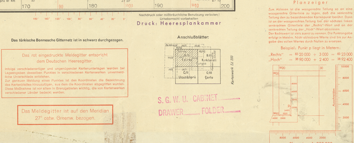
At the bottom right there's some red text. In the corner it tells you how to read coordinates off the map (basically its an early UTM) while a bit to the right it tells you, also in red, that the red grid is the "Deutsches Heeresgitter" centered around 27° E (it's based on the Bessel ellipsoid, similar to DHDN, but older). In black above this it says, that the black grid is the "turkish Bonnesche grid" (never heard of this one). enter image description here

So either you do some research on one of these, or you use the degrees which are noted at the map borders - depending on how exactly you would need the digitalisation to be.