Reduced scope to prevent being too broad
Source Link
PolyGeo
  • 65.4k
  • 29
  • 114
  • 345

How can I create a Creating connected network of roads from overlapping roads using R?

I am trying to create a dataset of roads data to do shortest path analysis. To do this, my roads data needs to be connected: it should be possible to jump from one road to another. I am planning to use the R library shp2graph for this. This library contains a function nt.connect that finds the largest connected network. However, this function finds that my data hardly overlaps, despite appearing to overlap on visual inspection. The function returns the following image to visualise these separate networks: unconnected roads network
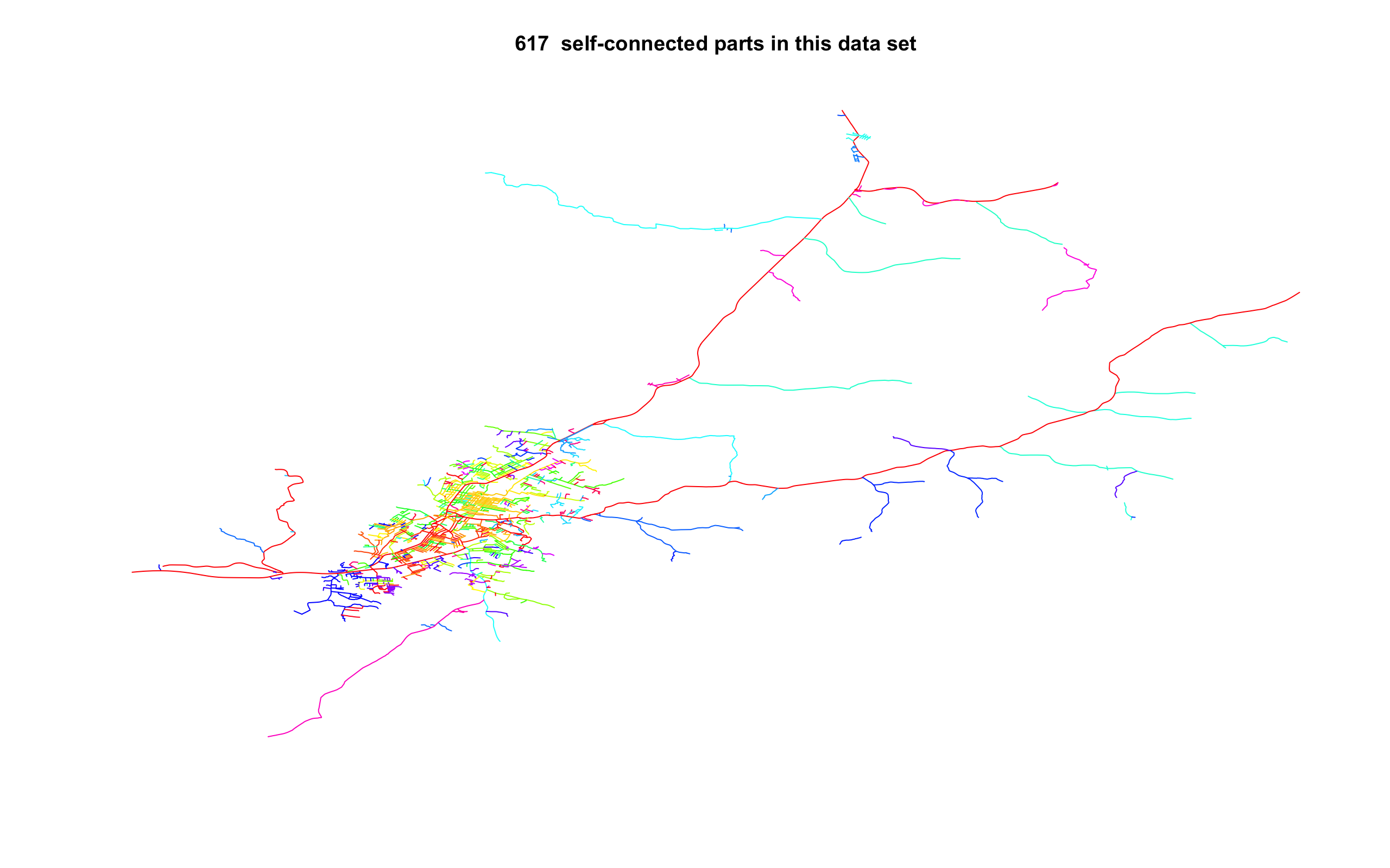
How can I connect these overlapping pieces of road to each other?

What I've tried:

  • Buffering the roads network. This returns a SpatialPolygon object which nt.connect does not accept: it wants a SpatialLines object. If I would convert the SpatialPolygon object to a SpatialLines object it would take the boundary of the Polygon, which would result in two roads right next to each other. I am worried this will mess with the subsequent analysis.

Some notes:

  • I am using OpenStreetMap data. The dataset (a subset of my full dataset) can be downloaded here: https://www.dropbox.com/sh/qu2fg3f9fy5tk7k/AABjv81Vv1R9c0RHuMJwIHH2a?dl=0
  • This is only a (very small) portion of the full roads network I want to use. Manually making sure they overlap is therefore not feasible
  • This library I am planning to use uses R. An answer using Python or QGIS3 is also possible as I use these regularly. Most important is that the approach is scriptable. My work needs to be fully reproducible and this is difficult when working with a GUI.
  • Some pieces of the road are true "orphans": they do not overlap with the larger network. I would prefer if these can be incorporated into the main network, for example by drawing the shortest possible line to the full network. I would also be fine with just dropping these orphans.

Below is the code to check that the network is connected:

require(sf) 
require(sp)
require(shp2graph)

setwd(dirname(rstudioapi::getActiveDocumentContext()$path))
roads <- read_sf("../GIS Stack example", "roads")
roads_sp <- as(roads, "Spatial")
roads_connected <- nt.connect(roads_sp)

How can I create a connected network of roads from overlapping roads?

I am trying to create a dataset of roads data to do shortest path analysis. To do this, my roads data needs to be connected: it should be possible to jump from one road to another. I am planning to use the R library shp2graph for this. This library contains a function nt.connect that finds the largest connected network. However, this function finds that my data hardly overlaps, despite appearing to overlap on visual inspection. The function returns the following image to visualise these separate networks: unconnected roads network

How can I connect these overlapping pieces of road to each other?

What I've tried:

  • Buffering the roads network. This returns a SpatialPolygon object which nt.connect does not accept: it wants a SpatialLines object. If I would convert the SpatialPolygon object to a SpatialLines object it would take the boundary of the Polygon, which would result in two roads right next to each other. I am worried this will mess with the subsequent analysis.

Some notes:

  • I am using OpenStreetMap data. The dataset (a subset of my full dataset) can be downloaded here: https://www.dropbox.com/sh/qu2fg3f9fy5tk7k/AABjv81Vv1R9c0RHuMJwIHH2a?dl=0
  • This is only a (very small) portion of the full roads network I want to use. Manually making sure they overlap is therefore not feasible
  • This library I am planning to use uses R. An answer using Python or QGIS3 is also possible as I use these regularly. Most important is that the approach is scriptable. My work needs to be fully reproducible and this is difficult when working with a GUI.
  • Some pieces of the road are true "orphans": they do not overlap with the larger network. I would prefer if these can be incorporated into the main network, for example by drawing the shortest possible line to the full network. I would also be fine with just dropping these orphans.

Below is the code to check that the network is connected:

require(sf) 
require(sp)
require(shp2graph)

setwd(dirname(rstudioapi::getActiveDocumentContext()$path))
roads <- read_sf("../GIS Stack example", "roads")
roads_sp <- as(roads, "Spatial")
roads_connected <- nt.connect(roads_sp)

Creating connected network of roads from overlapping roads using R?

I am trying to create a dataset of roads data to do shortest path analysis. To do this, my roads data needs to be connected: it should be possible to jump from one road to another. I am planning to use the R library shp2graph for this. This library contains a function nt.connect that finds the largest connected network. However, this function finds that my data hardly overlaps, despite appearing to overlap on visual inspection. The function returns the following image to visualise these separate networks: unconnected roads network

How can I connect these overlapping pieces of road to each other?

What I've tried:

  • Buffering the roads network. This returns a SpatialPolygon object which nt.connect does not accept: it wants a SpatialLines object. If I would convert the SpatialPolygon object to a SpatialLines object it would take the boundary of the Polygon, which would result in two roads right next to each other. I am worried this will mess with the subsequent analysis.

Some notes:

  • I am using OpenStreetMap data. The dataset (a subset of my full dataset) can be downloaded here: https://www.dropbox.com/sh/qu2fg3f9fy5tk7k/AABjv81Vv1R9c0RHuMJwIHH2a?dl=0
  • This is only a (very small) portion of the full roads network I want to use. Manually making sure they overlap is therefore not feasible
  • This library I am planning to use uses R. My work needs to be fully reproducible and this is difficult when working with a GUI.
  • Some pieces of the road are true "orphans": they do not overlap with the larger network. I would prefer if these can be incorporated into the main network, for example by drawing the shortest possible line to the full network. I would also be fine with just dropping these orphans.

Below is the code to check that the network is connected:

require(sf) 
require(sp)
require(shp2graph)

setwd(dirname(rstudioapi::getActiveDocumentContext()$path))
roads <- read_sf("../GIS Stack example", "roads")
roads_sp <- as(roads, "Spatial")
roads_connected <- nt.connect(roads_sp)
Source Link

How can I create a connected network of roads from overlapping roads?

I am trying to create a dataset of roads data to do shortest path analysis. To do this, my roads data needs to be connected: it should be possible to jump from one road to another. I am planning to use the R library shp2graph for this. This library contains a function nt.connect that finds the largest connected network. However, this function finds that my data hardly overlaps, despite appearing to overlap on visual inspection. The function returns the following image to visualise these separate networks: unconnected roads network

How can I connect these overlapping pieces of road to each other?

What I've tried:

  • Buffering the roads network. This returns a SpatialPolygon object which nt.connect does not accept: it wants a SpatialLines object. If I would convert the SpatialPolygon object to a SpatialLines object it would take the boundary of the Polygon, which would result in two roads right next to each other. I am worried this will mess with the subsequent analysis.

Some notes:

  • I am using OpenStreetMap data. The dataset (a subset of my full dataset) can be downloaded here: https://www.dropbox.com/sh/qu2fg3f9fy5tk7k/AABjv81Vv1R9c0RHuMJwIHH2a?dl=0
  • This is only a (very small) portion of the full roads network I want to use. Manually making sure they overlap is therefore not feasible
  • This library I am planning to use uses R. An answer using Python or QGIS3 is also possible as I use these regularly. Most important is that the approach is scriptable. My work needs to be fully reproducible and this is difficult when working with a GUI.
  • Some pieces of the road are true "orphans": they do not overlap with the larger network. I would prefer if these can be incorporated into the main network, for example by drawing the shortest possible line to the full network. I would also be fine with just dropping these orphans.

Below is the code to check that the network is connected:

require(sf) 
require(sp)
require(shp2graph)

setwd(dirname(rstudioapi::getActiveDocumentContext()$path))
roads <- read_sf("../GIS Stack example", "roads")
roads_sp <- as(roads, "Spatial")
roads_connected <- nt.connect(roads_sp)