English usage; naming
Source Link
Vince
  • 20.3k
  • 16
  • 48
  • 65

Show leafletLeaflet markers that falls inside mapbounds,based based on geocode location entered , from database

I have a GUI application where data from my database are displayed on a table and also displayed as markers on leafletLeaflet map  . I have added the Geocode ( LL.Control.geocoder()  ) function into my application  , and want to now show the markers, from my database  , that fits into the map bounds of where my Geocode location is.

I have read up on map.toBBoxString() and map.getBounds() from leafletLeaflet documentation which is what I think I would need to make a comparison and write a query for my database data to display in the 'Geo-coded' location entered . My problem is I don't know how to get the actual values and make a comparison for my Python query . Below is my search button part of code that connects to function to display data entered from user on table and map .

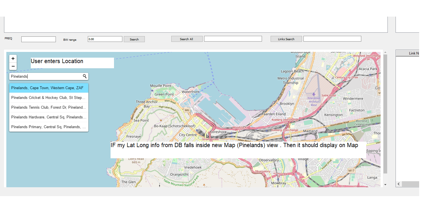
I basically want to achieve following  : User enters a certain Location on the Map with the Leaflet Geocode function  . The Map then go'sgoes to that location  . In addition to that  , I want my markers displayed that fit within the map bounds  . Thus if my Lat Long info in DB falls within map bounds  , display it on map  .  Map View

Show leaflet markers that falls inside mapbounds,based on geocode location entered , from database

I have a GUI application where data from my database are displayed on a table and also displayed as markers on leaflet map  . I have added the Geocode ( L.Control.geocoder()  ) function into my application  , and want to now show the markers, from my database  , that fits into the map bounds of where my Geocode location is.

I have read up on map.toBBoxString() and map.getBounds() from leaflet documentation which is what I think I would need to make a comparison and write a query for my database data to display in the 'Geo-coded' location entered . My problem is I don't know how to get the actual values and make a comparison for my Python query . Below is my search button part of code that connects to function to display data entered from user on table and map .

I basically want to achieve following  : User enters a certain Location on the Map with the Leaflet Geocode function  . The Map then go's to that location  . In addition to that  , I want my markers displayed that fit within the map bounds  . Thus if my Lat Long info in DB falls within map bounds  , display it on map  .Map View

Show Leaflet markers that falls inside mapbounds, based on geocode location entered from database

I have a GUI application where data from my database are displayed on a table and also displayed as markers on Leaflet map. I have added the Geocode (L.Control.geocoder()) function into my application, and want to now show the markers, from my database, that fits into the map bounds of where my Geocode location is.

I have read up on map.toBBoxString() and map.getBounds() from Leaflet documentation which is what I think I would need to make a comparison and write a query for my database data to display in the 'Geo-coded' location entered . My problem is I don't know how to get the actual values and make a comparison for my Python query . Below is my search button part of code that connects to function to display data entered from user on table and map .

I basically want to achieve following: User enters a certain Location on the Map with the Leaflet Geocode function. The Map then goes to that location. In addition to that, I want my markers displayed that fit within the map bounds. Thus if my Lat Long info in DB falls within map bounds, display it on map.  Map View

Source Link
Garth
  • 11
  • 1

Show leaflet markers that falls inside mapbounds,based on geocode location entered , from database

I have a GUI application where data from my database are displayed on a table and also displayed as markers on leaflet map . I have added the Geocode ( L.Control.geocoder() ) function into my application , and want to now show the markers, from my database , that fits into the map bounds of where my Geocode location is.

I have read up on map.toBBoxString() and map.getBounds() from leaflet documentation which is what I think I would need to make a comparison and write a query for my database data to display in the 'Geo-coded' location entered . My problem is I don't know how to get the actual values and make a comparison for my Python query . Below is my search button part of code that connects to function to display data entered from user on table and map .

Part of the code below :


def search_all(self):


        print ('Searching All...')
        looking = str(self.lookall.text())       
        if looking == "":
            QMessageBox.about(self, "No Info ", " Please enter value ")         
        else :

            conn = #connection to DB

            cursor = conn.cursor()        
            query = "SELECT*FROM CT_ALL_F WHERE Lic_no LIKE  '%s' OR Licensee LIKE '%s' OR FREQ LIKE '%s' OR Power LIKE '%s' OR Installation_address LIKE '%s' OR Business_address LIKE '%s' OR Tel LIKE '%s' " %('%'+looking+'%','%'+looking+'%','%'+looking+'%','%'+looking+'%','%'+looking+'%','%'+looking+'%','%'+looking+'%')        
            cursor.execute(query)    
            results = cursor.fetchall()

            self.tableWidget.setRowCount(0)            
            for row_number, row_data in enumerate(results):                
                self.tableWidget.insertRow(row_number)                
                for column_number, data in enumerate (row_data):                                        
                    self.tableWidget.setItem(row_number,column_number,QtWidgets.QTableWidgetItem(str(data)))                    
                    pass
                pass

                coordinates = []

                for result in results:        
                    coordinates.append((result[5], result[6] ,(result[0], result[1],result[2],result[3],result[4])))


                lat_center = sum([coordinate[0] for coordinate in coordinates]) / len(coordinates)
                lng_center = sum([coordinate[1] for coordinate in coordinates]) / len(coordinates)

                html = """
                        <!DOCTYPE html>
                        <html>
                        <head>
                        <style type="text/css">
                                html { height: 100%; }
                                body { height: 100%; margin: 0; padding: 0 }
                                #mapid { height: 100% }
                        </style>
                        <link rel="stylesheet" href="https://unpkg.com/[email protected]/dist/leaflet.css" integrity="sha512-Rksm5RenBEKSKFjgI3a41vrjkw4EVPlJ3+OiI65vTjIdo9brlAacEuKOiQ5OFh7cOI1bkDwLqdLw3Zg0cRJAAQ==" crossorigin=""/>
                        <script src="https://unpkg.com/[email protected]/dist/leaflet.js" integrity="sha512-/Nsx9X4HebavoBvEBuyp3I7od5tA0UzAxs+j83KgC8PU0kgB4XiK4Lfe4y4cgBtaRJQEIFCW+oC506aPT2L1zw==" crossorigin=""></script>

                        <link rel="stylesheet" href="https://unpkg.com/leaflet-control-geocoder/dist/Control.Geocoder.css" />
                        <script src="https://unpkg.com/leaflet-control-geocoder/dist/Control.Geocoder.js"></script>


                        </head>
                        <body>
                        <div id="mapDiv" style="width:100%; height:100%"</div>
                        <script>

                        """

                html += "var map = L.map('mapDiv').setView([{lat}, {lng}], 10);".format(lat=lat_center, lng=lng_center)                
                html += """
                        L.tileLayer('https://{s}.tile.openstreetmap.org/{z}/{x}/{y}.png', {
                        attribution: '&copy; <a href="https://www.icasa.org.za/">ICASA</a> <br> <a href="https://www.openstreetmap.org/">OpenStreetMap</a> contributors',
                        }).addTo(map);

                        """

                for latitude, longitude , frequency in coordinates:

                    html += "var marker = L.marker([{lat}, {lng}]);\n ".format(lat=latitude, lng=longitude)                   
                    html += "var popupLocation1 = new L.LatLng({lat}, {lng});".format(lat=latitude, lng=longitude )                    
                    html += """var popupContent1 = ("License number : {freq}<br>Licensee: {dek}<br>Frequency : {lek}<br>Power : {sek}<br>Location : {mek}<br>"),""".format(freq=frequency[0],dek=frequency[1],lek=frequency[2],sek=frequency[3],mek=frequency[4])
                    html += "popup1 = new L.Popup();"
                    html += "popup1.setLatLng(popupLocation1);"
                    html += "popup1.setContent(popupContent1);"
                    html+= "marker.bindPopup(popupContent1);"
                    html += "map.addLayer(popup1).addLayer(marker);"

                    html += "L.Control.geocoder().addTo(map);</script> </body> </html>"
                self.view.setHtml(html)

I basically want to achieve following : User enters a certain Location on the Map with the Leaflet Geocode function . The Map then go's to that location . In addition to that , I want my markers displayed that fit within the map bounds . Thus if my Lat Long info in DB falls within map bounds , display it on map .Map View
DB Sample