Bumped by Community user
deleted 12 characters in body
Source Link
Kadir Şahbaz
  • 78k
  • 57
  • 257
  • 404

Good day

I have drone imagery which was generated in Agisoft. From the imagery a DEM was generated and exported.

I would like to know how do iI get the Digital Terrain Model from this DEM? as I currently have the Digital Surface Model?

The method I have tried doing was creating points at different locations in between the trees(on the ground) and interpolating the points to create a DTM by subtracting the DSM and DTM (DSM-DTM= tree height) from each other.

However the results are not consistent enough to achieve tree heights accurately.

I do have ArcGIS Pro.

ortho

DEM

Good day

I have drone imagery which was generated in Agisoft. From the imagery a DEM was generated and exported.

I would like to know how do i get the Digital Terrain Model from this DEM? as I currently have the Digital Surface Model?

The method I have tried doing was creating points at different locations in between the trees(on the ground) and interpolating the points to create a DTM by subtracting the DSM and DTM (DSM-DTM= tree height) from each other.

However the results are not consistent enough to achieve tree heights accurately.

I do have ArcGIS Pro.
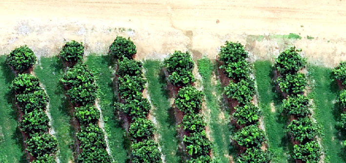
ortho

DEM

I have drone imagery which was generated in Agisoft. From the imagery a DEM was generated and exported.

I would like to know how do I get the Digital Terrain Model from this DEM? as I currently have the Digital Surface Model?

The method I have tried doing was creating points at different locations in between the trees(on the ground) and interpolating the points to create a DTM by subtracting the DSM and DTM (DSM-DTM= tree height) from each other.

However the results are not consistent enough to achieve tree heights accurately.

I do have ArcGIS Pro.

ortho

DEM

Source Link

How do I get accurate DTM from DSM to get tree height?

Good day

I have drone imagery which was generated in Agisoft. From the imagery a DEM was generated and exported.

I would like to know how do i get the Digital Terrain Model from this DEM? as I currently have the Digital Surface Model?

The method I have tried doing was creating points at different locations in between the trees(on the ground) and interpolating the points to create a DTM by subtracting the DSM and DTM (DSM-DTM= tree height) from each other.

However the results are not consistent enough to achieve tree heights accurately.

I do have ArcGIS Pro.

ortho

DEM