Added clarifications
Source Link
Ralph Tee
  • 1.8k
  • 13
  • 17

1)
If this was your reference tool, then the correct EPSG would be EPSG:3006, i.e., SWEREF 99 TM. This is (further) confirmed using the official Control Points

2) It also appears that your "flat Easting coordinate" value i.e., 1677500 looks off. Perhaps the correct value was 677500?

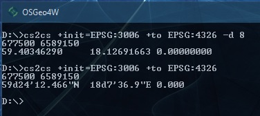
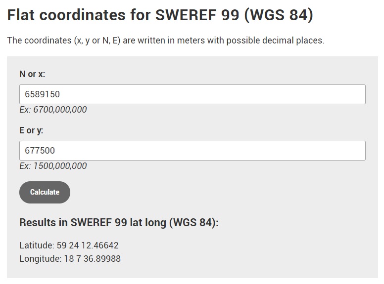
3) Using 6589150N and 677500E, the results are as below.

enter image description here

enter image description here


Reply to comment from Questioner

Question perspective your are right, but I actual problem is values of X and Y. >It should be interchanged and value 1677500->167750

The SWEREF 99 web tool uses X for (N)orthing or Latitude, and Y for (E)asting or longitude. This is a rather unfortunate choice, although not technically incorrect, because most software, including proj4.js, use X for longitude and Y for latitude.

If your Easting is 167750, then it won't compute. You can try it yourself in the SWEREF 99 web tool. And 1677500 appears "out of bound".

1)
If this was your reference tool, then the correct EPSG would be EPSG:3006, i.e., SWEREF 99 TM. This is (further) confirmed using the official Control Points

2) It also appears that your "flat Easting coordinate" value i.e., 1677500 looks off. Perhaps the correct value was 677500?

3) Using 6589150N and 677500E, the results are as below.

enter image description here

enter image description here


Reply to comment from Questioner

Question perspective your are right, but I actual problem is values of X and Y. >It should be interchanged and value 1677500->167750

The SWEREF 99 web tool uses X for (N)orthing or Latitude, and Y for (E)asting or longitude. This is a rather unfortunate choice, although not technically incorrect, because most software, including proj4.js, use X for longitude and Y for latitude.

If your Easting is 167750, then it won't compute. You can try it yourself in the SWEREF 99 web tool. And 1677500 appears "out of bound".
Source Link
Ralph Tee
  • 1.8k
  • 13
  • 17

1)
If this was your reference tool, then the correct EPSG would be EPSG:3006, i.e., SWEREF 99 TM. This is (further) confirmed using the official Control Points

2) It also appears that your "flat Easting coordinate" value i.e., 1677500 looks off. Perhaps the correct value was 677500?

3) Using 6589150N and 677500E, the results are as below.

enter image description here

enter image description here