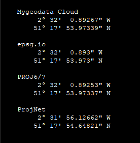
PROJ6/7 (via cs2cs) returned the result as below.
If we convert all those results to sexagesimal, we can see that they all concur except for Proj.Net.
To convert a pair of OSGB 1936 planimetric coordinates to "WGS84" geodetic coordinates, the steps are as follow :
Step 1:
Reverse project the OSGB 1936 easting and northing coordinates.
Output is a pair of geodetic coordinates on the Airy ellipsoid.
Step 2:
Convert the geodetic coordinates to 3D cartesian coordinates.
Output is a set of (geocentric ECEF) XYZ coordinates (in the OSGB 36 reference frame ???).
Step 3:
Apply 7-parameter Helmert transformation.
Output is a set of XYZ coordinates in the "WGS84" reference frame.
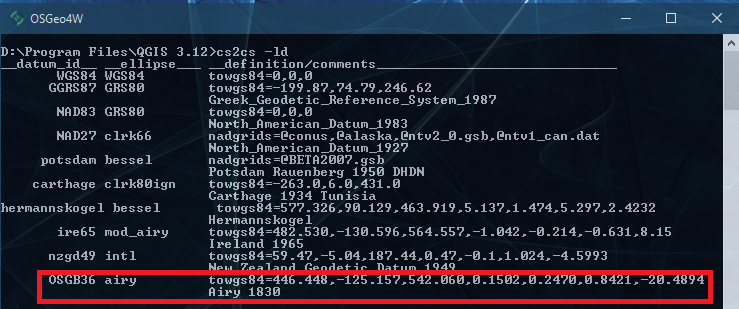
The parameter values are as below.
Step 4:
Convert the transformed 3D cartesian coordinates to geodetic coordinates on the WGS84 ellipsoid.
PROJ automatically does all the steps above if the its coordinate system database (proj.db) is present, or if you specify it explicitly e.g., via the "+towgs84" parameter.
It appears that (at this time of writing) Proj.Net does not (yet) do auto coordinate transformation although all the codes are already there, which means Coders with some knowledge in coordinate system will be able to make them workswork. For now, it stops at Step 2. Thus Proj.Net's output is actually a pair of geodetic coordinates on the Airy ellipsoid (in the OSGB 36 reference frame???)
Proj.Net is a fantastic project for the .NET community, and hopefully we will seehave more contributors to bring it up to speed.
A caveat:
While PROJ, Mygeodata Cloud, and epsg.io may concur on the output, and be methodologically and mathematically correct, but this doesn't necessarily mean they are authoritatively correct unless someone can validate that the Helmert seven-parameter (shown above) are correct. (I am not ahaven't done any UK subjectOrdnance projects, so I can't tell.)


