improved formatting, crossed out broken link.
Source Link
Andre Silva
  • 10.3k
  • 12
  • 55
  • 109

ifIf you are interested with pythonusing Python, you can read a good doc.documentation is available at GeospatialPython.com, here.

and clipraster.py source is here.and clipraster.py source is here.
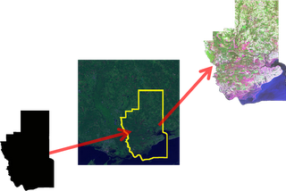
clipping

The Process:

Clipping a raster is a series of simple button clicks in high-end geospatial software packages. In terms of computing, geospatial images are actually very large, multi-dimensional arrays. Remote Sensing at its simplest is performing mathematical operations on these arrays to extract information from the data. Behind the scenes here is what the software is doing (give or take a few steps):

  1. Convert the vector shapefile to a matrix which can be used as mask
  2. Load the geospatial image into a matrix
  3. Throw out any image cells outside of the shapefile extent
  4. Set all values outside the shapefile boundary to NODATA (null) values
  5. OPTIONAL: Perform a histogram stretch on the image for better visualization
  6. Save the resulting image as a new raster.

if you interested with python, you can read a good doc. at GeospatialPython.com, here.

and clipraster.py source is here.

clipping

The Process

Clipping a raster is a series of simple button clicks in high-end geospatial software packages. In terms of computing, geospatial images are actually very large, multi-dimensional arrays. Remote Sensing at its simplest is performing mathematical operations on these arrays to extract information from the data. Behind the scenes here is what the software is doing (give or take a few steps):

  1. Convert the vector shapefile to a matrix which can be used as mask
  2. Load the geospatial image into a matrix
  3. Throw out any image cells outside of the shapefile extent
  4. Set all values outside the shapefile boundary to NODATA (null) values
  5. OPTIONAL: Perform a histogram stretch on the image for better visualization
  6. Save the resulting image as a new raster.

If you are interested using Python, a good documentation is available at GeospatialPython.com, here.

and clipraster.py source is here.

clipping

The Process:

Clipping a raster is a series of simple button clicks in high-end geospatial software packages. In terms of computing, geospatial images are actually very large, multi-dimensional arrays. Remote Sensing at its simplest is performing mathematical operations on these arrays to extract information from the data. Behind the scenes here is what the software is doing (give or take a few steps):

  1. Convert the vector shapefile to a matrix which can be used as mask
  2. Load the geospatial image into a matrix
  3. Throw out any image cells outside of the shapefile extent
  4. Set all values outside the shapefile boundary to NODATA (null) values
  5. OPTIONAL: Perform a histogram stretch on the image for better visualization
  6. Save the resulting image as a new raster.
deleted 27 characters in body
Source Link
PolyGeo
  • 65.4k
  • 29
  • 114
  • 345

if you interested with python, you can read a good doc. at GeospatialPython.com, here.

and clipraster.py source is here.

clipping

The Process

Clipping a raster is a series of simple button clicks in high-end geospatial software packages. In terms of computing, geospatial images are actually very large, multi-dimensional arrays. Remote Sensing at its simplest is performing mathematical operations on these arrays to extract information from the data. Behind the scenes here is what the software is doing (give or take a few steps):

  1. Convert the vector shapefile to a matrix which can be used as mask
  2. Load the geospatial image into a matrix
  3. Throw out any image cells outside of the shapefile extent
  4. Set all values outside the shapefile boundary to NODATA (null) values
  5. OPTIONAL: Perform a histogram stretch on the image for better visualization
  6. Save the resulting image as a new raster.

i hope it helps you...

if you interested with python, you can read a good doc. at GeospatialPython.com, here.

and clipraster.py source is here.

clipping

The Process

Clipping a raster is a series of simple button clicks in high-end geospatial software packages. In terms of computing, geospatial images are actually very large, multi-dimensional arrays. Remote Sensing at its simplest is performing mathematical operations on these arrays to extract information from the data. Behind the scenes here is what the software is doing (give or take a few steps):

  1. Convert the vector shapefile to a matrix which can be used as mask
  2. Load the geospatial image into a matrix
  3. Throw out any image cells outside of the shapefile extent
  4. Set all values outside the shapefile boundary to NODATA (null) values
  5. OPTIONAL: Perform a histogram stretch on the image for better visualization
  6. Save the resulting image as a new raster.
Source Link
urcm
  • 22.6k
  • 4
  • 58
  • 109

if you interested with python, you can read a good doc. at GeospatialPython.com, here.

and clipraster.py source is here.

clipping

The Process

Clipping a raster is a series of simple button clicks in high-end geospatial software packages. In terms of computing, geospatial images are actually very large, multi-dimensional arrays. Remote Sensing at its simplest is performing mathematical operations on these arrays to extract information from the data. Behind the scenes here is what the software is doing (give or take a few steps):

  1. Convert the vector shapefile to a matrix which can be used as mask
  2. Load the geospatial image into a matrix
  3. Throw out any image cells outside of the shapefile extent
  4. Set all values outside the shapefile boundary to NODATA (null) values
  5. OPTIONAL: Perform a histogram stretch on the image for better visualization
  6. Save the resulting image as a new raster.

i hope it helps you...