Post Closed as "Opinion-based" by Ian Turton
corrected spellings, and grammar
Source Link
Kadir Şahbaz
  • 78k
  • 57
  • 257
  • 404

I'm developing an application that contains a tilted map based on OL-Cesium. The "camera" height is very low (zoom level is the highest), and the view is "moving" continuously, like a car navigation in 3D view. The moving speed is between 0 and 70 km/h. The map has some tileWMS layers published by GeoServer. There are no problems with them. However, there is a polygon layer with dynamically changing content (inserts in about every second). The source of this layer is a PostGIS table.

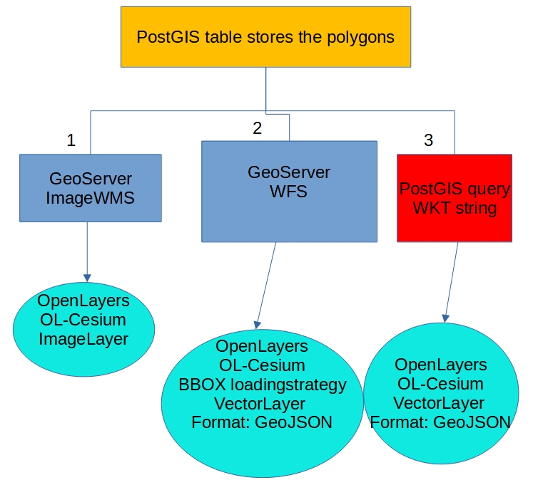
Now, I'm trying some methods to put this data onto the map. I think that the tileWMS is not an appropriate choice for dynamically changing data. Now, I tried the ImageWMS. It performs well in 2D view, but in 3D it is very slow (and the polygons look very bad due to the high scale). The second option is the WFS with GeoJSON format and BBOX loading strategy. In this case, the problem is the very high CPU and the RAM using is growing continuously. So, now I'm trying to find a better solution:

1. Call a function with a defined frequency (50-100 ms) which selects the polygons from the PostGIS table that are within X meters like this:


      SELECT ST_AsText(ST_Collect(geom)) FROM table t WHERE
      ST_Dwithin(t.geom,ST_SetSRID(ST_Point(x_coord,y_coord),4326)),0.003);

2. Store the results in WKT format in a string.
3. Pass the WKT string to the OpenLayers.
4. Refresh the data source of the vector layer like this:

    >    function refreshVectorSource(polygonWKT) {
    >     vectorSource.clear();
    >     var format = new ol.format.GeoJSON({
    >     featureProjection:"EPSG:4326"
    >         });
    >     vectorSource.addFeatures(format.readFeatures(polygonWKT))};
  1. Call a function with a defined frequency (50-100 ms) which selects the polygons from the PostGIS table that are within X meters like this:

    SELECT ST_AsText(ST_Collect(geom)) FROM table t WHERE
    ST_Dwithin(t.geom,ST_SetSRID(ST_Point(x_coord,y_coord),4326)),0.003);
    
  2. Store the results in WKT format in a string.

  3. Pass the WKT string to the OpenLayers.

  4. Refresh the data source of the vector layer like this:

    function refreshVectorSource(polygonWKT) {
      vectorSource.clear();
      var format = new ol.format.GeoJSON({
        featureProjection: "EPSG:4326"
      });
      vectorSource.addFeatures(format.readFeatures(polygonWKT))
    };
    

What do you think? Do you have any suggestions? Or any other idea?

enter image description here

I'm developing an application that contains a tilted map based on OL-Cesium. The "camera" height is very low (zoom level is the highest), and the view is "moving" continuously, like a car navigation in 3D view. The moving speed is between 0 and 70 km/h. The map has some tileWMS layers published by GeoServer. There are no problems with them. However, there is a polygon layer with dynamically changing content (inserts in about every second). The source of this layer is a PostGIS table.

Now, I'm trying some methods to put this data onto the map. I think that the tileWMS is not an appropriate choice for dynamically changing data. Now, I tried the ImageWMS. It performs well in 2D view, but in 3D it is very slow (and the polygons look very bad due to the high scale). The second option is the WFS with GeoJSON format and BBOX loading strategy. In this case, the problem is the very high CPU and the RAM using is growing continuously. So, now I'm trying to find a better solution:

1. Call a function with a defined frequency (50-100 ms) which selects the polygons from the PostGIS table that are within X meters like this:


      SELECT ST_AsText(ST_Collect(geom)) FROM table t WHERE
      ST_Dwithin(t.geom,ST_SetSRID(ST_Point(x_coord,y_coord),4326)),0.003);

2. Store the results in WKT format in a string.
3. Pass the WKT string to the OpenLayers.
4. Refresh the data source of the vector layer like this:

    >    function refreshVectorSource(polygonWKT) {
    >     vectorSource.clear();
    >     var format = new ol.format.GeoJSON({
    >     featureProjection:"EPSG:4326"
    >         });
    >     vectorSource.addFeatures(format.readFeatures(polygonWKT))};

What do you think? Do you have any suggestions? Or any other idea?

enter image description here

I'm developing an application that contains a tilted map based on OL-Cesium. The "camera" height is very low (zoom level is the highest), and the view is "moving" continuously, like a car navigation in 3D view. The moving speed is between 0 and 70 km/h. The map has some tileWMS layers published by GeoServer. There are no problems with them. However, there is a polygon layer with dynamically changing content (inserts in about every second). The source of this layer is a PostGIS table.

Now, I'm trying some methods to put this data onto the map. I think that the tileWMS is not an appropriate choice for dynamically changing data. Now, I tried the ImageWMS. It performs well in 2D view, but in 3D it is very slow (and the polygons look very bad due to the high scale). The second option is the WFS with GeoJSON format and BBOX loading strategy. In this case, the problem is the very high CPU and the RAM using is growing continuously. So, now I'm trying to find a better solution:

  1. Call a function with a defined frequency (50-100 ms) which selects the polygons from the PostGIS table that are within X meters like this:

    SELECT ST_AsText(ST_Collect(geom)) FROM table t WHERE
    ST_Dwithin(t.geom,ST_SetSRID(ST_Point(x_coord,y_coord),4326)),0.003);
    
  2. Store the results in WKT format in a string.

  3. Pass the WKT string to the OpenLayers.

  4. Refresh the data source of the vector layer like this:

    function refreshVectorSource(polygonWKT) {
      vectorSource.clear();
      var format = new ol.format.GeoJSON({
        featureProjection: "EPSG:4326"
      });
      vectorSource.addFeatures(format.readFeatures(polygonWKT))
    };
    

What do you think? Do you have any suggestions? Or any other idea?
enter image description here

I'm developing an application whichthat contains a tilted map based on OL-Cesium. The "camera" height is very low (zoom level is the highest), and the view is "moving" continuously, like a car navigation in 3D view. The moving speed is between 0 and 70 km/h. The map has some tileWMS layers published by GeoServer. There are no problems with them. However, there is a polygon layer with dinamicallydynamically changing content (inserts in about every secondssecond). The source of this layer is a PostGIS table.

Now, I'm trying some methods to put this data onto the map. I think that the tileWMS is not an appropriate choice for dinamically changeingdynamically changing data. Now, I tried the ImageWMS. It performs well in 2D view, but in 3D it is very slow (and the polygons lookslook very bad due to of the high scale). The second option is the WFS with GeoJSON format and BBOX loading strategy. In this case, the problem is the very high CPU and the RAM using is growing continouslycontinuously. So, now I'm trying to find a better solution:

  1. Call a function with a defined frequency (50-100 ms) which selects the polygons from the PostGIS table that are within X meters like this:

SELECT ST_AsText(ST_Collect(geom)) FROM table t WHERE ST_Dwithin(t.geom,ST_SetSRID(ST_Point(x_coord,y_coord),4326)),0.003);

  1. Store the results in WKT format in a string.
  2. Pass the WKT string to the OpenLayers.
  3. Refresh the data source of the vector layer like this:

function refreshVectorSource(polygonWKT) { vectorSource.clear(); var format = new ol.format.GeoJSON({ featureProjection:"EPSG:4326" }); vectorSource.addFeatures(format.readFeatures(polygonWKT))};

1. Call a function with a defined frequency (50-100 ms) which selects the polygons from the PostGIS table that are within X meters like this:


      SELECT ST_AsText(ST_Collect(geom)) FROM table t WHERE
      ST_Dwithin(t.geom,ST_SetSRID(ST_Point(x_coord,y_coord),4326)),0.003);

2. Store the results in WKT format in a string.
3. Pass the WKT string to the OpenLayers.
4. Refresh the data source of the vector layer like this:

    >    function refreshVectorSource(polygonWKT) {
    >     vectorSource.clear();
    >     var format = new ol.format.GeoJSON({
    >     featureProjection:"EPSG:4326"
    >         });
    >     vectorSource.addFeatures(format.readFeatures(polygonWKT))};

What do you think? Do you have any suggestionsuggestions? Or any other idea?

enter image description here

I'm developing an application which contains a tilted map based on OL-Cesium. The "camera" height is very low (zoom level is the highest), and the view is "moving" continuously, like a car navigation in 3D view. The moving speed is between 0 and 70 km/h. The map has some tileWMS layers published by GeoServer. There are no problems with them. However there is a polygon layer with dinamically changing content (inserts in about every seconds). The source of this layer is a PostGIS table.

Now, I'm trying some methods to put this data onto the map. I think that the tileWMS is not an appropriate choice for dinamically changeing data. Now, I tried the ImageWMS. It performs well in 2D view, but in 3D it is very slow (and the polygons looks very bad due to of the high scale). The second option is the WFS with GeoJSON format and BBOX loading strategy. In this case the problem is the very high CPU and the RAM using is growing continously. So, now I'm trying to find a better solution:

  1. Call a function with a defined frequency (50-100 ms) which selects the polygons from the PostGIS table that are within X meters like this:

SELECT ST_AsText(ST_Collect(geom)) FROM table t WHERE ST_Dwithin(t.geom,ST_SetSRID(ST_Point(x_coord,y_coord),4326)),0.003);

  1. Store the results in WKT format in a string.
  2. Pass the WKT string to the OpenLayers.
  3. Refresh the data source of the vector layer like this:

function refreshVectorSource(polygonWKT) { vectorSource.clear(); var format = new ol.format.GeoJSON({ featureProjection:"EPSG:4326" }); vectorSource.addFeatures(format.readFeatures(polygonWKT))};

What do you think? Do you have any suggestion? Or any other idea?

enter image description here

I'm developing an application that contains a tilted map based on OL-Cesium. The "camera" height is very low (zoom level is the highest), and the view is "moving" continuously, like a car navigation in 3D view. The moving speed is between 0 and 70 km/h. The map has some tileWMS layers published by GeoServer. There are no problems with them. However, there is a polygon layer with dynamically changing content (inserts in about every second). The source of this layer is a PostGIS table.

Now, I'm trying some methods to put this data onto the map. I think that the tileWMS is not an appropriate choice for dynamically changing data. Now, I tried the ImageWMS. It performs well in 2D view, but in 3D it is very slow (and the polygons look very bad due to the high scale). The second option is the WFS with GeoJSON format and BBOX loading strategy. In this case, the problem is the very high CPU and the RAM using is growing continuously. So, now I'm trying to find a better solution:

1. Call a function with a defined frequency (50-100 ms) which selects the polygons from the PostGIS table that are within X meters like this:


      SELECT ST_AsText(ST_Collect(geom)) FROM table t WHERE
      ST_Dwithin(t.geom,ST_SetSRID(ST_Point(x_coord,y_coord),4326)),0.003);

2. Store the results in WKT format in a string.
3. Pass the WKT string to the OpenLayers.
4. Refresh the data source of the vector layer like this:

    >    function refreshVectorSource(polygonWKT) {
    >     vectorSource.clear();
    >     var format = new ol.format.GeoJSON({
    >     featureProjection:"EPSG:4326"
    >         });
    >     vectorSource.addFeatures(format.readFeatures(polygonWKT))};

What do you think? Do you have any suggestions? Or any other idea?

enter image description here

edited title
Link
MrXsquared
  • 35.6k
  • 22
  • 71
  • 121

Displaying dinamicallydynamically changing data layer in moving view using OL-Cesium

Source Link
zsoooc
  • 349
  • 3
  • 16
Loading