added 2 characters in body
Source Link
Taras
  • 34k
  • 4
  • 73
  • 148

For PyQGIS it is grass7"grass7:v.to.lineslines"

For PyQGIS it is grass7:v.to.lines

For PyQGIS it is "grass7:v.to.lines"

added 62 characters in body
Source Link
Taras
  • 34k
  • 4
  • 73
  • 148

Another option is the GRASS's v.to.lines (search in the Processing Toolbox Ctrl+Alt+T). For PyQGIS it is

Another option is the GRASS's v.to.lines. For PyQGIS it is

Another option is the GRASS's v.to.lines (search in the Processing Toolbox Ctrl+Alt+T).

added 3284 characters in body
Source Link
Taras
  • 34k
  • 4
  • 73
  • 148

Another option is the GRASS's v.to.lines. For PyQGIS it is

Output:
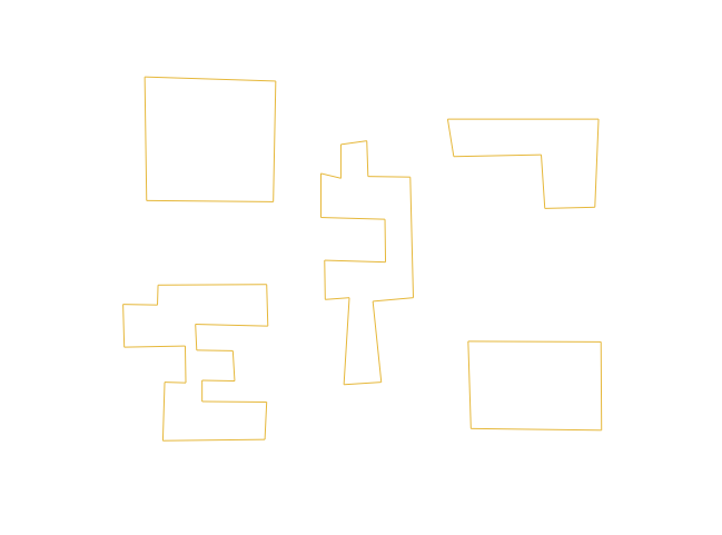
output

For PyQGIS it is grass7:v.to.lines

>>> processing.algorithmHelp("grass7:v.to.lines")
v.to.lines (grass7:v.to.lines)

Converts vector polygons or points to lines.


----------------
Input parameters
----------------

input: Name of input vector map

    Parameter type: QgsProcessingParameterFeatureSource

    Accepted data types:
        - str: layer ID
        - str: layer name
        - str: layer source
        - QgsProcessingFeatureSourceDefinition
        - QgsProperty
        - QgsVectorLayer

method: Method used for point interpolation

    Parameter type: QgsProcessingParameterEnum

    Available values:
        - 0: delaunay

    Accepted data types:
        - int
        - str: as string representation of int, e.g. '1'
        - QgsProperty

output: Lines

    Parameter type: QgsProcessingParameterVectorDestination

    Accepted data types:
        - str
        - QgsProperty
        - QgsProcessingOutputLayerDefinition

GRASS_REGION_PARAMETER: GRASS GIS 7 region extent

    Parameter type: QgsProcessingParameterExtent

    Accepted data types:
        - str: as comma delimited list of x min, x max, y min, y max. E.g. '4,10,101,105'
        - str: layer ID. Extent of layer is used.
        - str: layer name. Extent of layer is used.
        - str: layer source. Extent of layer is used.
        - QgsMapLayer: Extent of layer is used
        - QgsProcessingFeatureSourceDefinition: Extent of source is used
        - QgsProperty
        - QgsRectangle
        - QgsReferencedRectangle
        - QgsGeometry: bounding box of geometry is used

GRASS_SNAP_TOLERANCE_PARAMETER: v.in.ogr snap tolerance (-1 = no snap)

    Parameter type: QgsProcessingParameterNumber

    Accepted data types:
        - int
        - float
        - QgsProperty

GRASS_MIN_AREA_PARAMETER: v.in.ogr min area

    Parameter type: QgsProcessingParameterNumber

    Accepted data types:
        - int
        - float
        - QgsProperty

GRASS_OUTPUT_TYPE_PARAMETER: v.out.ogr output type

    Parameter type: QgsProcessingParameterEnum

    Available values:
        - 0: auto
        - 1: point
        - 2: line
        - 3: area

    Accepted data types:
        - int
        - str: as string representation of int, e.g. '1'
        - QgsProperty

GRASS_VECTOR_DSCO: v.out.ogr output data source options (dsco)

    Parameter type: QgsProcessingParameterString

    Accepted data types:
        - str
        - QgsProperty

GRASS_VECTOR_LCO: v.out.ogr output layer options (lco)

    Parameter type: QgsProcessingParameterString

    Accepted data types:
        - str
        - QgsProperty

GRASS_VECTOR_EXPORT_NOCAT: Also export features without category (not labeled). Otherwise only features with category are exported

    Parameter type: QgsProcessingParameterBoolean

    Accepted data types:
        - bool
        - int
        - str
        - QgsProperty

----------------
Outputs
----------------

output:  <QgsProcessingOutputVectorLayer>
    Lines

Another option is the GRASS's v.to.lines

Output:
output

Another option is the GRASS's v.to.lines. For PyQGIS it is

Output:
output

For PyQGIS it is grass7:v.to.lines

>>> processing.algorithmHelp("grass7:v.to.lines")
v.to.lines (grass7:v.to.lines)

Converts vector polygons or points to lines.


----------------
Input parameters
----------------

input: Name of input vector map

    Parameter type: QgsProcessingParameterFeatureSource

    Accepted data types:
        - str: layer ID
        - str: layer name
        - str: layer source
        - QgsProcessingFeatureSourceDefinition
        - QgsProperty
        - QgsVectorLayer

method: Method used for point interpolation

    Parameter type: QgsProcessingParameterEnum

    Available values:
        - 0: delaunay

    Accepted data types:
        - int
        - str: as string representation of int, e.g. '1'
        - QgsProperty

output: Lines

    Parameter type: QgsProcessingParameterVectorDestination

    Accepted data types:
        - str
        - QgsProperty
        - QgsProcessingOutputLayerDefinition

GRASS_REGION_PARAMETER: GRASS GIS 7 region extent

    Parameter type: QgsProcessingParameterExtent

    Accepted data types:
        - str: as comma delimited list of x min, x max, y min, y max. E.g. '4,10,101,105'
        - str: layer ID. Extent of layer is used.
        - str: layer name. Extent of layer is used.
        - str: layer source. Extent of layer is used.
        - QgsMapLayer: Extent of layer is used
        - QgsProcessingFeatureSourceDefinition: Extent of source is used
        - QgsProperty
        - QgsRectangle
        - QgsReferencedRectangle
        - QgsGeometry: bounding box of geometry is used

GRASS_SNAP_TOLERANCE_PARAMETER: v.in.ogr snap tolerance (-1 = no snap)

    Parameter type: QgsProcessingParameterNumber

    Accepted data types:
        - int
        - float
        - QgsProperty

GRASS_MIN_AREA_PARAMETER: v.in.ogr min area

    Parameter type: QgsProcessingParameterNumber

    Accepted data types:
        - int
        - float
        - QgsProperty

GRASS_OUTPUT_TYPE_PARAMETER: v.out.ogr output type

    Parameter type: QgsProcessingParameterEnum

    Available values:
        - 0: auto
        - 1: point
        - 2: line
        - 3: area

    Accepted data types:
        - int
        - str: as string representation of int, e.g. '1'
        - QgsProperty

GRASS_VECTOR_DSCO: v.out.ogr output data source options (dsco)

    Parameter type: QgsProcessingParameterString

    Accepted data types:
        - str
        - QgsProperty

GRASS_VECTOR_LCO: v.out.ogr output layer options (lco)

    Parameter type: QgsProcessingParameterString

    Accepted data types:
        - str
        - QgsProperty

GRASS_VECTOR_EXPORT_NOCAT: Also export features without category (not labeled). Otherwise only features with category are exported

    Parameter type: QgsProcessingParameterBoolean

    Accepted data types:
        - bool
        - int
        - str
        - QgsProperty

----------------
Outputs
----------------

output:  <QgsProcessingOutputVectorLayer>
    Lines
Source Link
Taras
  • 34k
  • 4
  • 73
  • 148
Loading