Bumped by Community user
added 7 characters in body
Source Link

I have a CAD drawing (Both DWG and DXF formats) which looks like below when it's been opened in AutoCad.

As you can see there are annotations and what not. These are features in which I'd like to extract in a GIS setting enter image description here
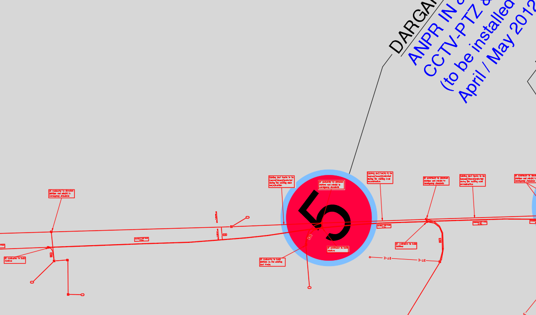
To do this, I opened the CAD drawing in ArcGIS Pro and used the CAD TO GEODATABASE to convert the drawing to a geodatabase feature dataset,

It has turned out like below:

Is there any way to replicate the exact CAD drawing? The feature dataset below will require alota lot of work to get the desire finished output

enter image description here

Another example of what I mean:

This text box clearly contains text (I have blocked it out for confidentiality) as per the original CAD drawing   

enter image description here

However, the ArcGIS Pro version shows the outline of text box and a point to represent the text. However, when I click the point it doesn't actually contain what was in the text box. It just says text and the layer name   

enter image description here

I have a CAD drawing (Both DWG and DXF formats) which looks like below when it's been opened in AutoCad.

As you can see there are annotations and what not. These are features in which I'd like to extract in a GIS setting enter image description here

To do this, I opened the CAD drawing in ArcGIS Pro and used the CAD TO GEODATABASE to convert the drawing to a geodatabase feature dataset,

It has turned out like below:

Is there any way to replicate the exact CAD drawing? The feature dataset below will require alot of work to get the desire finished output

enter image description here

Another example of what I mean:

This text box clearly contains text (I have blocked it out for confidentiality) as per the original CAD drawing  enter image description here

However, the ArcGIS Pro version shows the outline of text box and a point to represent the text. However, when I click the point it doesn't actually contain what was in the text box. It just says text and the layer name  enter image description here
I have a CAD drawing (Both DWG and DXF formats) which looks like below when it's been opened in AutoCad.

As you can see there are annotations and what not. These are features in which I'd like to extract in a GIS setting enter image description here

To do this, I opened the CAD drawing in ArcGIS Pro and used the CAD TO GEODATABASE to convert the drawing to a geodatabase feature dataset,

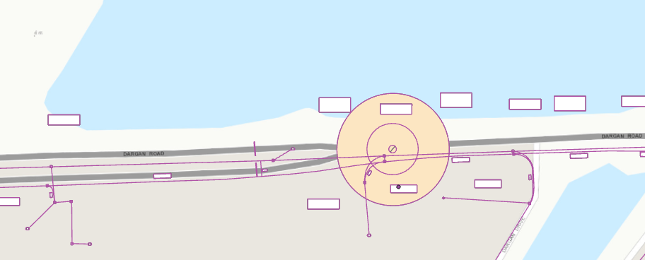
It has turned out like below:

Is there any way to replicate the exact CAD drawing? The feature dataset below will require a lot of work to get the desire finished output

enter image description here

Another example of what I mean:

This text box clearly contains text (I have blocked it out for confidentiality) as per the original CAD drawing 

enter image description here

However, the ArcGIS Pro version shows the outline of text box and a point to represent the text. However, when I click the point it doesn't actually contain what was in the text box. It just says text and the layer name 

enter image description here

added 551 characters in body
Source Link

I have a CAD drawing (Both DWG and DXF formats) which looks like below when it's been opened in AutoCad.

As you can see there are annotations and what not. These are features in which I'd like to extract in a GIS setting enter image description here

To do this, I opened the CAD drawing in ArcGIS Pro and used the CAD TO GEODATABASE to convert the drawing to a geodatabase feature dataset,

It has turned out like below:

Is there any way to replicate the exact CAD drawing? The feature dataset below will require alot of work to get the desire finished output

enter image description here

Another example of what I mean:

This text box clearly contains text (I have blocked it out for confidentiality) as per the original CAD drawing enter image description here

However, the ArcGIS Pro version shows the outline of text box and a point to represent the text. However, when I click the point it doesn't actually contain what was in the text box. It just says text and the layer name enter image description here
I have a CAD drawing (Both DWG and DXF formats) which looks like below when it's been opened in AutoCad.

As you can see there are annotations and what not. These are features in which I'd like to extract in a GIS setting enter image description here

To do this, I opened the CAD drawing in ArcGIS Pro and used the CAD TO GEODATABASE to convert the drawing to a geodatabase feature dataset,

It has turned out like below:

Is there any way to replicate the exact CAD drawing? The feature dataset below will require alot of work to get the desire finished output

enter image description here

Another example of what I mean:

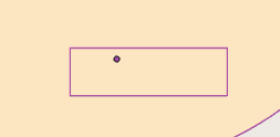
This text box clearly contains text (I have blocked it out for confidentiality) as per the original CAD drawing enter image description here

However, the ArcGIS Pro version shows the outline of text box and a point to represent the text. However, when I click the point it doesn't actually contain what was in the text box. It just says text and the layer name enter image description here

Source Link

Using CAD drawing in ArcGIS Pro

I have a CAD drawing (Both DWG and DXF formats) which looks like below when it's been opened in AutoCad.

As you can see there are annotations and what not. These are features in which I'd like to extract in a GIS setting enter image description here

To do this, I opened the CAD drawing in ArcGIS Pro and used the CAD TO GEODATABASE to convert the drawing to a geodatabase feature dataset,

It has turned out like below:

Is there any way to replicate the exact CAD drawing? The feature dataset below will require alot of work to get the desire finished output

enter image description here