deleted 73 characters in body
Source Link
PolyGeo
  • 65.4k
  • 29
  • 114
  • 345

community! II have a layer on GeoserverGeoServer which includes lots of organizations. Different organizations can be on the same point. SLD style for this layer:

I understand, that meta_buffer of mapproxy should do the trick, but somewhere it helps and somewhere not. So guys, may be i missing an easy way to do the job?

Thanks!

Update:


community! I have a layer on Geoserver which includes lots of organizations. Different organizations can be on the same point. SLD style for this layer:

I understand, that meta_buffer of mapproxy should do the trick, but somewhere it helps and somewhere not. So guys, may be i missing an easy way to do the job?

Thanks!

Update:

I have a layer on GeoServer which includes lots of organizations. Different organizations can be on the same point. SLD style for this layer:

I understand, that meta_buffer of mapproxy should do the trick, but somewhere it helps and somewhere not.

 
added 155 characters in body
Source Link
SMT
  • 1
  • 1

Update:

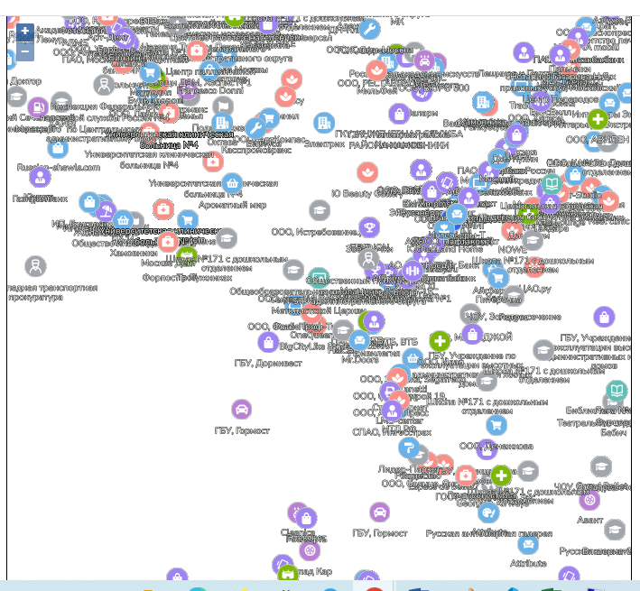
After disabling conflictResolution i have this:

enter image description here

Update:

After disabling conflictResolution i have this:

enter image description here

Source Link
SMT
  • 1
  • 1

Geoserver + Mapproxy label conflicts on seeding

community! I have a layer on Geoserver which includes lots of organizations. Different organizations can be on the same point. SLD style for this layer:

<?xml version="1.0" encoding="UTF-8"?>
<sld:StyledLayerDescriptor
    xmlns="http://www.opengis.net/sld"
    xmlns:sld="http://www.opengis.net/sld"
    xmlns:gml="http://www.opengis.net/gml"
    xmlns:ogc="http://www.opengis.net/ogc" version="1.0.0">
    <sld:Name>hybrid_org</sld:Name>
    <sld:NamedLayer>
        <sld:Name>firms_2gis_info</sld:Name>
        <sld:UserStyle>
            <sld:Name>Default Styler</sld:Name>
            <sld:FeatureTypeStyle>
                <sld:Name>firms_2gis_info</sld:Name>
                <sld:Title>MBStyle firms_2gis_info</sld:Title>
                <sld:Abstract>Generated for firms_2gis_info</sld:Abstract>
                <sld:Rule>
                    <sld:Name>firms_2gis_info</sld:Name>
                    <ogc:Filter>
                        <ogc:PropertyIsEqualTo>
                            <ogc:Function name="in">
                                <ogc:PropertyName>layer_id</ogc:PropertyName>
                                <ogc:Literal>poi_emergency_01</ogc:Literal>
                                <ogc:Literal>poi_culture_02</ogc:Literal>
                                <ogc:Literal>poi_culture_03</ogc:Literal>
                                <ogc:Literal>poi_leisure_02</ogc:Literal>
                                <ogc:Literal>poi_sport_04</ogc:Literal>
                                <ogc:Literal>poi_leisure_01</ogc:Literal>
                            </ogc:Function>
                            <ogc:Literal>false</ogc:Literal>
                        </ogc:PropertyIsEqualTo>
                    </ogc:Filter>
                    <sld:MinScaleDenominator>266.5911979441132</sld:MinScaleDenominator>
                    <sld:MaxScaleDenominator>17061.836668423246</sld:MaxScaleDenominator>
                    <sld:TextSymbolizer uom="http://www.opengeospatial.org/se/units/pixel">
                        <sld:Label>
                            <ogc:PropertyName>feature_name</ogc:PropertyName>
                        </sld:Label>
                        <sld:Font>
                            <sld:CssParameter name="font-family">
                                <ogc:Function name="fontAlternatives">
                                    <ogc:Literal>OpenSans-Bold</ogc:Literal>
                                </ogc:Function>
                            </sld:CssParameter>
                            <sld:CssParameter name="font-size">10</sld:CssParameter>
                            <sld:CssParameter name="font-style">normal</sld:CssParameter>
                            <sld:CssParameter name="font-weight">normal</sld:CssParameter>
                        </sld:Font>
                        <sld:LabelPlacement>
                            <sld:PointPlacement>
                                <sld:AnchorPoint>
                                    <sld:AnchorPointX>0.5</sld:AnchorPointX>
                                    <sld:AnchorPointY>1.0</sld:AnchorPointY>
                                </sld:AnchorPoint>
                                <sld:Displacement>
                                    <sld:DisplacementX>
                                        <ogc:Mul>
                                            <ogc:Literal>10</ogc:Literal>
                                            <ogc:Literal>0</ogc:Literal>
                                        </ogc:Mul>
                                    </sld:DisplacementX>
                                    <sld:DisplacementY>
                                        <ogc:Mul>
                                            <ogc:Literal>10</ogc:Literal>
                                            <ogc:Mul>
                                                <ogc:Literal>-1</ogc:Literal>
                                                <ogc:Literal>0.5</ogc:Literal>
                                            </ogc:Mul>
                                        </ogc:Mul>
                                    </sld:DisplacementY>
                                </sld:Displacement>
                            </sld:PointPlacement>
                        </sld:LabelPlacement>
                        <sld:Halo>
                            <sld:Radius>0.5</sld:Radius>
                            <sld:Fill>
                                <sld:CssParameter name="fill">#131813</sld:CssParameter>
                            </sld:Fill>
                        </sld:Halo>
                        <sld:Fill>
                            <sld:CssParameter name="fill">#FFFFFF</sld:CssParameter>
                        </sld:Fill>
                        <sld:Graphic>
                            <sld:ExternalGraphic>
                                <sld:OnlineResource
                                    xmlns:xlink="http://www.w3.org/1999/xlink" xlink:type="simple" xlink:href="image"/>
                                    <sld:Format>mbsprite</sld:Format>
                                </sld:ExternalGraphic>
                                <sld:AnchorPoint>
                                    <sld:AnchorPointX>0.5</sld:AnchorPointX>
                                    <sld:AnchorPointY>0.0</sld:AnchorPointY>
                                </sld:AnchorPoint>
                                <sld:Displacement>
                                    <sld:DisplacementX>
                                        <ogc:Mul>
                                            <ogc:Literal>0.5</ogc:Literal>
                                            <ogc:Literal>0</ogc:Literal>
                                        </ogc:Mul>
                                    </sld:DisplacementX>
                                    <sld:DisplacementY>
                                        <ogc:Mul>
                                            <ogc:Literal>0.5</ogc:Literal>
                                            <ogc:Mul>
                                                <ogc:Literal>-1</ogc:Literal>
                                                <ogc:Literal>0</ogc:Literal>
                                            </ogc:Mul>
                                        </ogc:Mul>
                                    </sld:DisplacementY>
                                </sld:Displacement>
                            </sld:Graphic>
                            <sld:Priority>1000</sld:Priority>
                            <sld:VendorOption name="repeat">0</sld:VendorOption>
                            <sld:VendorOption name="conflictResolution">true</sld:VendorOption>
                            <sld:VendorOption name="graphic-resize">NONE</sld:VendorOption>
                            <sld:VendorOption name="partials">true</sld:VendorOption>
                            <sld:VendorOption name="graphic-margin">0</sld:VendorOption>
                            <sld:VendorOption name="spaceAround">25</sld:VendorOption>
                            <sld:VendorOption name="autoWrap">150.0</sld:VendorOption>
                            <sld:VendorOption name="graphicPlacement">INDEPENDENT</sld:VendorOption>
                            <sld:VendorOption name="labelObstacle">false</sld:VendorOption>
                            <sld:VendorOption name="fallbackOnDefaultMark">false</sld:VendorOption>
                        </sld:TextSymbolizer>
                    </sld:Rule>
                </sld:FeatureTypeStyle>
            </sld:UserStyle>
        </sld:NamedLayer>
    </sld:StyledLayerDescriptor>

So, in wms it looks ok: OK wms
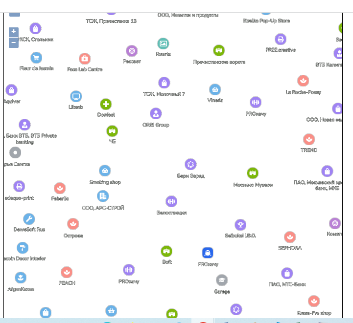
When i try to seed and cache with help of mapproxy it gives bad results. It cuts images on tile edges. Mapproxy settings like meta_tile_size and meta_buffer helps particullary. Somwhere it helps, somewhere problems are still here.

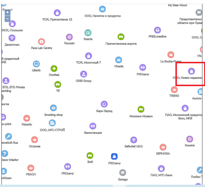
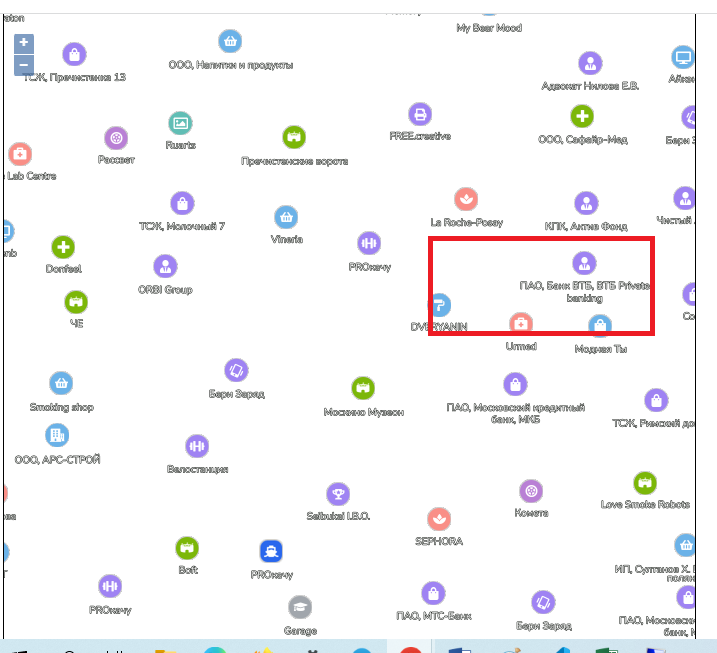
I understand why this happens. It happens because conflict resolution is different on different tiles. Example:

On this tile the organization in red box is visible, because the neighbour organization is not visible. If we move a little bit right, neighbour organization is visible and conflict resolution hide the first irganization. It means, that the organization will be cut on the tile edge.
enter image description here enter image description here

I understand, that meta_buffer of mapproxy should do the trick, but somewhere it helps and somewhere not. So guys, may be i missing an easy way to do the job?

Mapproxy - v1.14.0 Geoserver - v2.17.2

Thanks!