explained new research and attached image
Source Link

I have the following set of data.

Name Easting Northing
Point 1 7675 0576
Point 2 7758 0330
Point 3 7568 0864

I would like to know what coordinate system this data uses, to convert it to latitude and longitude later.

I did not find any documentation about the coordinate system used. The data is from an public university document.

I know the locations are somewhere in Zone 50 of WGS84 (West-Western Australia).

I saw on another question that projfinder.com usually helps in these situations, but I am unsure how to use it or analyse the results it returned.

Any ideas?

The data can be found here: https://library.dbca.wa.gov.au/static/FullTextFiles/069766.pdf See pages 178 - 182.

Any ideas?

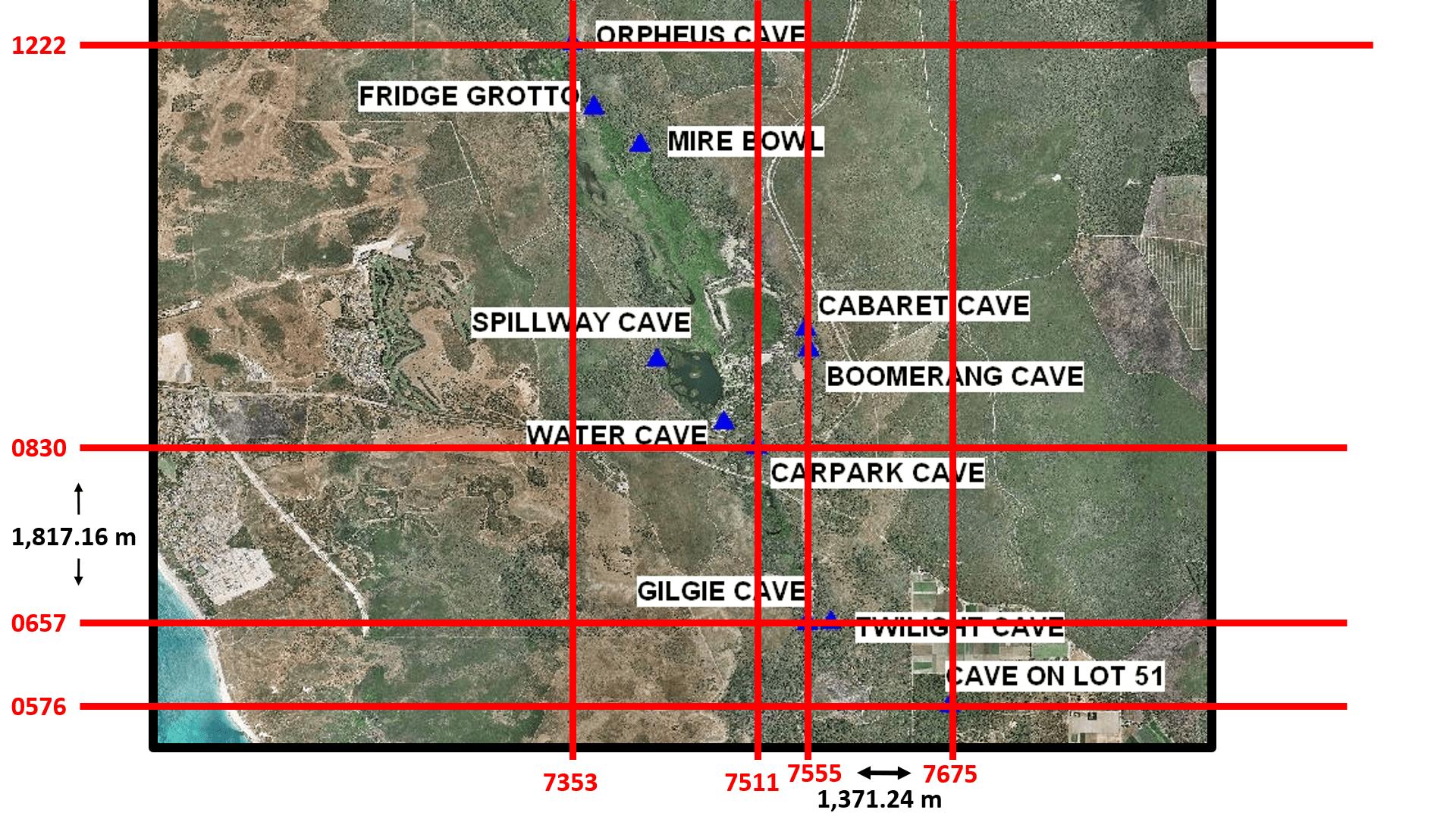
After using a map from here and the original data as seen here (see pages 178-182), I created this image. Does the image help identify the identify the coordinate system used in the set of data?
I have the following set of data.

Name Easting Northing
Point 1 7675 0576
Point 2 7758 0330
Point 3 7568 0864

I would like to know what coordinate system this data uses, to convert it to latitude and longitude later.

I did not find any documentation about the coordinate system used. The data is from an public university document.

I know the locations are somewhere in Zone 50 of WGS84 (West-Western Australia).

I saw on another question that projfinder.com usually helps in these situations, but I am unsure how to use it or analyse the results it returned.

Any ideas?

The data can be found here: https://library.dbca.wa.gov.au/static/FullTextFiles/069766.pdf See pages 178 - 182.

I have the following set of data.

Name Easting Northing
Point 1 7675 0576
Point 2 7758 0330
Point 3 7568 0864

I would like to know what coordinate system this data uses, to convert it to latitude and longitude later.

I did not find any documentation about the coordinate system used. The data is from an public university document.

I know the locations are somewhere in Zone 50 of WGS84 (West-Western Australia).

I saw on another question that projfinder.com usually helps in these situations, but I am unsure how to use it or analyse the results it returned.

The data can be found here: https://library.dbca.wa.gov.au/static/FullTextFiles/069766.pdf See pages 178 - 182.

Any ideas?

After using a map from here and the original data as seen here (see pages 178-182), I created this image. Does the image help identify the identify the coordinate system used in the set of data?

Changed wording and added link to data.
Source Link

I have the following set of data.

Name Easting Northing
Point 1 7675 0576
Point 2 7758 0330
Point 3 7568 0864

I would like to know what coordinate system this data uses, to convert it to latitude and longitude later.

I did not find any documentation which could give a clue about the coordinate system used. The data is from an public university document.

I know the locations are somewhere in Zone 50 of WGS84 (West-Western Australia).

I saw on another question that projfinder.com usually helps in these situations, but I am unsure how to use it or analyse the results it returned.

Any ideas?

The data can be found here: https://library.dbca.wa.gov.au/static/FullTextFiles/069766.pdf See pages 178 - 182.

I have the following set of data.

Name Easting Northing
Point 1 7675 0576
Point 2 7758 0330
Point 3 7568 0864

I would like to know what coordinate system this data uses, to convert it to latitude and longitude later.

I did not find any documentation which could give a clue about the coordinate system used. The data is from an public university document.

I know the locations are somewhere in Zone 50 of WGS84 (West-Western Australia).

I saw on another question that projfinder.com usually helps in these situations, but I am unsure how to use it or analyse the results it returned.

Any ideas?

I have the following set of data.

Name Easting Northing
Point 1 7675 0576
Point 2 7758 0330
Point 3 7568 0864

I would like to know what coordinate system this data uses, to convert it to latitude and longitude later.

I did not find any documentation about the coordinate system used. The data is from an public university document.

I know the locations are somewhere in Zone 50 of WGS84 (West-Western Australia).

I saw on another question that projfinder.com usually helps in these situations, but I am unsure how to use it or analyse the results it returned.

Any ideas?

The data can be found here: https://library.dbca.wa.gov.au/static/FullTextFiles/069766.pdf See pages 178 - 182.

changed 2 occurrences of datum to coordinate system, included Australia in title
Source Link
mkennedy
  • 19.1k
  • 2
  • 40
  • 61

Identifying the geographical datumcoordinate system in a set of Australian data

I have the following set of data.

Name Easting Northing
Point 1 7675 0576
Point 2 7758 0330
Point 3 7568 0864

I would like to know what datumcoordinate system this data uses, to convert it to latitude and longitude later.

I did not find any documentation which could give a clue about the coordinate system used. The data is from an public university document.

I know the locations are somewhere in Zone 50 of WGS84 (West-Western Australia).

I saw on another question that projfinder.com usually helps in these situations, but I am unsure how to use it or analyse the results it returned.

Any ideas?

Identifying the geographical datum in a set of data

I have the following set of data.

Name Easting Northing
Point 1 7675 0576
Point 2 7758 0330
Point 3 7568 0864

I would like to know what datum this data uses, to convert it to latitude and longitude later.

I did not find any documentation which could give a clue about the coordinate system used. The data is from an public university document.

I know the locations are somewhere in Zone 50 of WGS84 (West-Western Australia).

I saw on another question that projfinder.com usually helps in these situations, but I am unsure how to use it or analyse the results it returned.

Any ideas?

Identifying the coordinate system in a set of Australian data

I have the following set of data.

Name Easting Northing
Point 1 7675 0576
Point 2 7758 0330
Point 3 7568 0864

I would like to know what coordinate system this data uses, to convert it to latitude and longitude later.

I did not find any documentation which could give a clue about the coordinate system used. The data is from an public university document.

I know the locations are somewhere in Zone 50 of WGS84 (West-Western Australia).

I saw on another question that projfinder.com usually helps in these situations, but I am unsure how to use it or analyse the results it returned.

Any ideas?

Source Link
Loading