added 251 characters in body
Source Link
Babel
  • 74.9k
  • 15
  • 87
  • 227

You can export the project/map canvas as image: go to menu Project > ImporteImport/Export > Export Map to Image.... Make appropriate settings for resolution of the output raster an be sure to check the box Append georeference information (embedded or via world file).

Maximal resolution seems to be 3000 dpi, but for most uses, this is large enough (if not much too large). If you need more details, you can zoom in and define the extent of a layer (e.g. an auxiliary polygon layer you create just for that purpose).

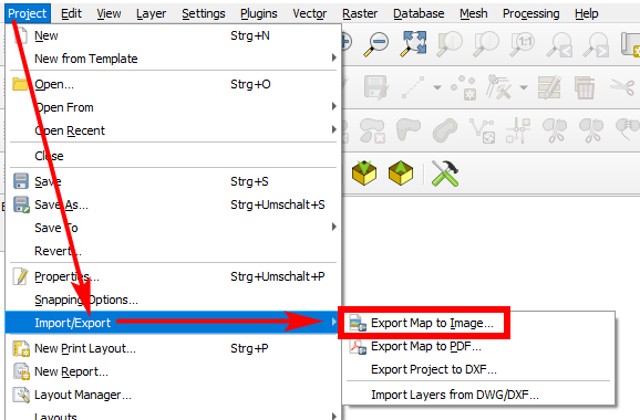
enter image description here

You can export the project/map canvas as image: go to menu Project > Importe/Export > Export Map to Image.... Make appropriate settings for resolution of the output raster an be sure to check the box Append georeference information (embedded or via world file).

enter image description here

You can export the project/map canvas as image: go to menu Project > Import/Export > Export Map to Image.... Make appropriate settings for resolution of the output raster an be sure to check the box Append georeference information (embedded or via world file).

Maximal resolution seems to be 3000 dpi, but for most uses, this is large enough (if not much too large). If you need more details, you can zoom in and define the extent of a layer (e.g. an auxiliary polygon layer you create just for that purpose).

enter image description here

Source Link
Babel
  • 74.9k
  • 15
  • 87
  • 227

You can export the project/map canvas as image: go to menu Project > Importe/Export > Export Map to Image.... Make appropriate settings for resolution of the output raster an be sure to check the box Append georeference information (embedded or via world file).

enter image description here