SELECT ST_Difference(
p.geom,
(SELECT ST_UnionST_UNION(geom)
FROM q
WHERE ST_IntersectsROWID IN(
SELECT id
FROM rtree_q_geom
WHERE minx <= MbrMaxX(p.geom, geom)
AND p.ROWIDmaxx IN>= MbrMinX(p.geom)
SELECT ROWID
AND FROMminy SpatialIndex<= MbrMaxY(p.geom)
WHERE f_table_name = 'p' AND maxy >= MbrMinY(p.geom)
AND search_frame =)
AND ST_Intersects(p.geom, geom)
)
) AS geom FROM pp;
As Pieter answer, there are many ways to query the spatial index.
Spatial indexes are trees where each node represent a rectangle that belongs within its parent node. A brief, outdated but useful introduction was described in: http://www.gaia-gis.it/gaia-sins/spatialite-cookbook/html/rtree.html
RegardingSpatiaLite implements a new way to query the spatial index, through the SpatialIndex table, it. It is a virtual table wrapping the rectangles tree, and it is presented in: https://gaia-gis.it/fossil/libspatialite/wiki?name=SpatialIndex.
But neither the GeoPackage standard (nor its GDAL implementation) includes it.
Regarding the ROWID attribute, it is documented in https://www.sqlite.org/lang_createtable.html#rowid. In the GeoPackage standard, the Feature ID attribute refers to it.
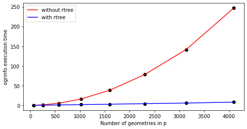
The complete code I tested is the following:
import geopandas as gpd
import shapely.geometry
import numpy as np
import time

np.random.seed(42)

elapsed_with_rtree = []
elapsed_without_rtree = []

ns = [8,16, 24, 32, 40, 48, 56, 64]

for n in ns:

    p = gpd.GeoSeries(
        [shapely.geometry.box(j, i, j + 1, i + 1) for i in range(n) for j in range(n)]
    )

    q = gpd.GeoSeries(
        [
            shapely.geometry.Point(e)
            for e in np.random.uniform(low=0, high=n, size=[n * n * 10, 2])
        ]
    ).buffer(distance=0.1)

    !rm -f united.gpkg
    p.to_file("united.gpkg",layer="p")
    q.to_file("united.gpkg",layer="q")

    query = """
        SELECT ST_Difference(
          p.geom,
          (SELECT ST_UNION(geom)
           FROM q
           WHERE ST_Intersects(p.geom,geom)
           )
        ) AS geom FROM p;
    """
    query = ' '.join(query.split())

    rtree_query = """
        SELECT ST_Difference(
          p.geom,
          (SELECT ST_UNION(geom)
           FROM q
           WHERE ROWID IN(
             SELECT id
             FROM rtree_q_geom
             WHERE minx <= MbrMaxX(p.geom)
               AND maxx >= MbrMinX(p.geom)
               AND miny <= MbrMaxY(p.geom)
               AND maxy >= MbrMinY(p.geom)
             )
           AND ST_Intersects(p.geom, geom)
           )
        ) AS geom FROM p;
    """
    rtree_query = ' '.join(rtree_query.split())

    t0 = time.time()
    subprocess.run(['ogrinfo', '-q', '-sql', query, 'united.gpkg'], stdout=subprocess.DEVNULL)
    t1 = time.time()
    subprocess.run(['ogrinfo', '-q', '-sql', rtree_query, 'united.gpkg'], stdout=subprocess.DEVNULL)
    t2 = time.time()

    elapsed_without_rtree.append(t1-t0)
    elapsed_with_rtree.append(t2-t1)


import matplotlib.pyplot as plt

plt.figure(figsize=(8,4))

plt.scatter([e**2 for e in ns], elapsed_without_rtree, c='k')
plt.plot([e**2 for e in ns], elapsed_without_rtree, c='r', label="without rtree")

plt.scatter([e**2 for e in ns], elapsed_with_rtree, c='k')
plt.plot([e**2 for e in ns], elapsed_with_rtree, c='b', label="with rtree")

plt.xlabel("Number of geometries in p")
plt.ylabel("ogrinfo execution time")

plt.legend()


