Became Hot Network Question
deleted 39 characters in body; edited tags; edited title
Source Link
Taras
  • 34k
  • 4
  • 73
  • 148

How to make a Making trivial GeoJSON file with a Feature collection of points

I'm trying to generate a GeoJSON file with a feature collection of points to render in QGIS, however, when I load my .geojson file I don't see anything. To figure out what's going on, I've tried to get a trivial file to load. Here is an example:

{ "type": "FeatureCollection",
  "features": [
    { "type": "Feature",
      "geometry": {
        "type": "Point",
        "coordinates": [-27.4670353, 153.013123]
      },
      "properties": {"prop0": "value0"}
    }
  ]
}
{ "type": "FeatureCollection",
  "features": [
    { "type": "Feature",
      "geometry": {
        "type": "Point",
        "coordinates": [-27.4670353, 153.013123]
      },
      "properties": {"prop0": "value0"}
    }
  ]
}

According to the GeoJSON documentation;

The coordinate reference system for all GeoJSON coordinates is a geographic coordinate reference system, using the World Geodetic System 1984 (WGS 84) datum, with longitude and latitude units of decimal degrees

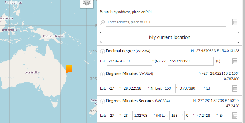
Sure enough, when I put the coordinates -27.4670353, 153.013123 into https://coordinates-converter.com/ I get a location somewhere in Brisbane, Australia:

enter image description here

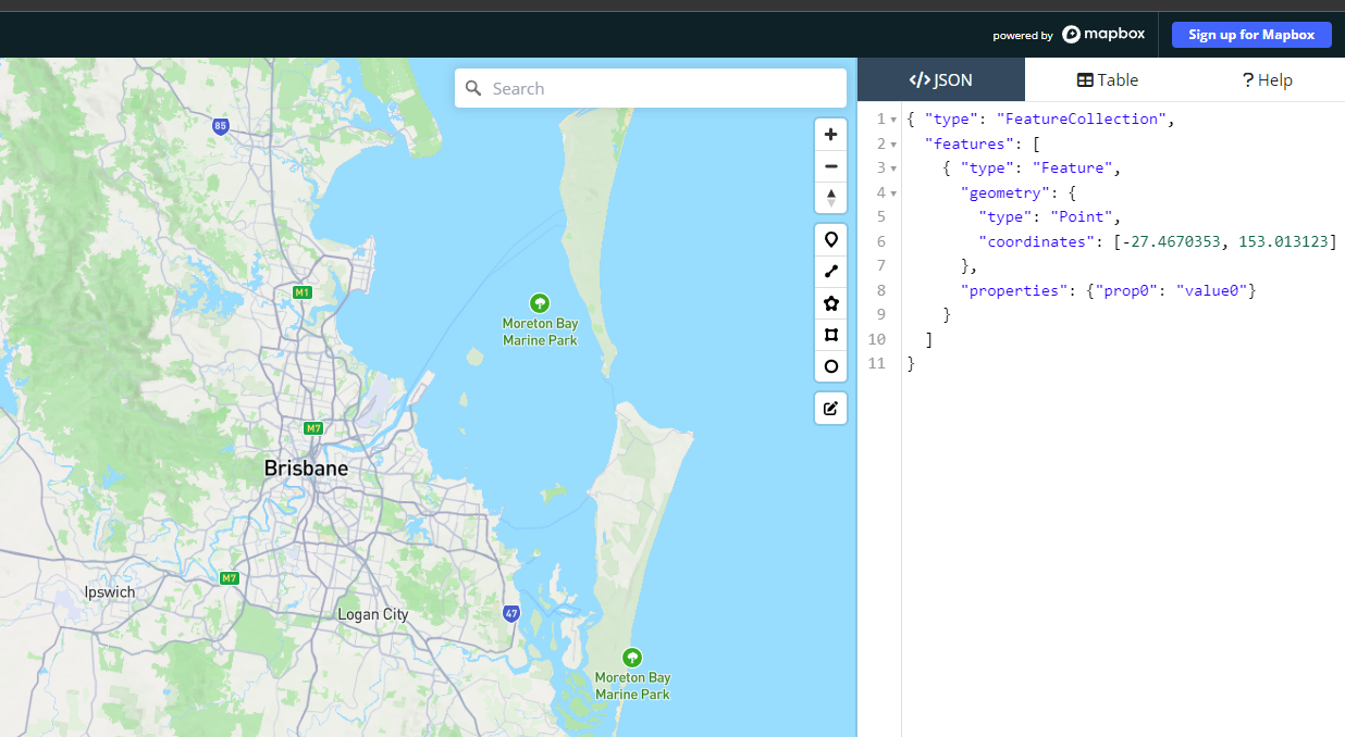
However, when I copy the above jsonJSON file into https://geojson.io/ I get nothing:

enter image description here

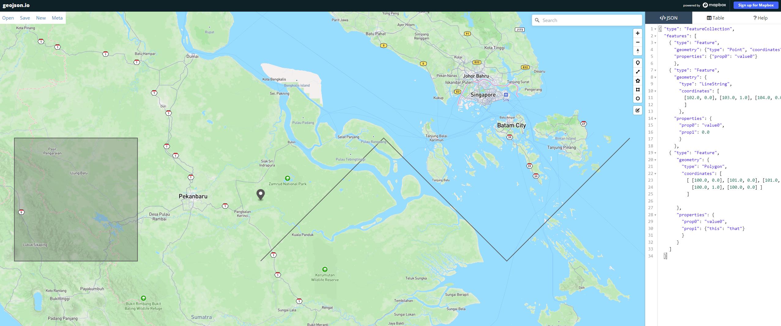
When I load the example geojsonGeoJSON file at https://gist.github.com/wavded/1200773?short_path=99c1af9 it does seem to work though:

enter image description here

However, to the best of my knowledge, these are not WGS84 decimal coordinates. What's happening here? I'm very new to GIS so I don't really understand what's going on.

How to make a trivial GeoJSON file with a Feature collection of points

I'm trying to generate a GeoJSON file with a feature collection of points to render in QGIS, however, when I load my .geojson file I don't see anything. To figure out what's going on I've tried to get a trivial file to load. Here is an example:

{ "type": "FeatureCollection",
  "features": [
    { "type": "Feature",
      "geometry": {
        "type": "Point",
        "coordinates": [-27.4670353, 153.013123]
      },
      "properties": {"prop0": "value0"}
    }
  ]
}

According to the GeoJSON documentation;

The coordinate reference system for all GeoJSON coordinates is a geographic coordinate reference system, using the World Geodetic System 1984 (WGS 84) datum, with longitude and latitude units of decimal degrees

Sure enough, when I put the coordinates -27.4670353, 153.013123 into https://coordinates-converter.com/ I get a location somewhere in Brisbane, Australia:

enter image description here

However, when I copy the above json file into https://geojson.io/ I get nothing:

enter image description here

When I load the example geojson file at https://gist.github.com/wavded/1200773?short_path=99c1af9 it does seem to work though:

enter image description here

However, to the best of my knowledge these are not WGS84 decimal coordinates. What's happening here? I'm very new to GIS so I don't really understand what's going on.
Making trivial GeoJSON file with Feature collection of points

I'm trying to generate a GeoJSON file with a feature collection of points to render in QGIS, however, when I load my .geojson file I don't see anything. To figure out what's going on, I've tried to get a trivial file to load. Here is an example:

{ "type": "FeatureCollection",
  "features": [
    { "type": "Feature",
      "geometry": {
        "type": "Point",
        "coordinates": [-27.4670353, 153.013123]
      },
      "properties": {"prop0": "value0"}
    }
  ]
}

According to the GeoJSON documentation;

The coordinate reference system for all GeoJSON coordinates is a geographic coordinate reference system, using the World Geodetic System 1984 (WGS 84) datum, with longitude and latitude units of decimal degrees

Sure enough, when I put the coordinates -27.4670353, 153.013123 into https://coordinates-converter.com/ I get a location somewhere in Brisbane, Australia:

enter image description here

However, when I copy the above JSON file into https://geojson.io/ I get nothing:

enter image description here

When I load the example GeoJSON file at https://gist.github.com/wavded/1200773?short_path=99c1af9 it does seem to work though:

enter image description here

However, to the best of my knowledge, these are not WGS84 decimal coordinates. What's happening here?

naming
Source Link
Vince
  • 20.3k
  • 16
  • 48
  • 65

How do Ito make a trivial GeojsonGeoJSON file with a Feature collection of points?

I'm trying to generate a geojsonGeoJSON file with a feature collection of points to render in QGIS, however, when I load my .geojson file I don't see anything. To figure out what's going on I've tried to get a trivial file to load. Here is an example:

{ "type": "FeatureCollection",
  "features": [
    { "type": "Feature",
      "geometry": {
        "type": "Point",
        "coordinates": [-27.4670353, 153.013123]
      },
      "properties": {"prop0": "value0"}
    }
  ]
}

According to the GeoJSON documentation;

The coordinate reference system for all GeoJSON coordinates is a geographic coordinate reference system, using the World Geodetic System 1984 (WGS 84) datum, with longitude and latitude units of decimal degrees

Sure enough, when I put the coordinates -27.4670353, 153.013123 into https://coordinates-converter.com/ I get a location somewhere in Brisbane, Australia:

enter image description here

However, when I copy the above json file into https://geojson.io/ I get nothing:

enter image description here

When I load the example geojson file at https://gist.github.com/wavded/1200773?short_path=99c1af9 it does seem to work though:

enter image description here

However, to the best of my knowledge these are not WGS84 decimal coordinates. What's happening here? I'm very new to GIS so I don't really understand what's going on.
How do I make a trivial Geojson file with a Feature collection of points?

I'm trying to generate a geojson file with a feature collection of points to render in QGIS, however, when I load my .geojson file I don't see anything. To figure out what's going on I've tried to get a trivial file to load. Here is an example:

{ "type": "FeatureCollection",
  "features": [
    { "type": "Feature",
      "geometry": {
        "type": "Point",
        "coordinates": [-27.4670353, 153.013123]
      },
      "properties": {"prop0": "value0"}
    }
  ]
}

According to the GeoJSON documentation;

The coordinate reference system for all GeoJSON coordinates is a geographic coordinate reference system, using the World Geodetic System 1984 (WGS 84) datum, with longitude and latitude units of decimal degrees

Sure enough, when I put the coordinates -27.4670353, 153.013123 into https://coordinates-converter.com/ I get a location somewhere in Brisbane, Australia:

enter image description here

However, when I copy the above json file into https://geojson.io/ I get nothing:

enter image description here

When I load the example geojson file at https://gist.github.com/wavded/1200773?short_path=99c1af9 it does seem to work though:

enter image description here

However, to the best of my knowledge these are not WGS84 decimal coordinates. What's happening here? I'm very new to GIS so I don't really understand what's going on.

How to make a trivial GeoJSON file with a Feature collection of points

I'm trying to generate a GeoJSON file with a feature collection of points to render in QGIS, however, when I load my .geojson file I don't see anything. To figure out what's going on I've tried to get a trivial file to load. Here is an example:

{ "type": "FeatureCollection",
  "features": [
    { "type": "Feature",
      "geometry": {
        "type": "Point",
        "coordinates": [-27.4670353, 153.013123]
      },
      "properties": {"prop0": "value0"}
    }
  ]
}

According to the GeoJSON documentation;

The coordinate reference system for all GeoJSON coordinates is a geographic coordinate reference system, using the World Geodetic System 1984 (WGS 84) datum, with longitude and latitude units of decimal degrees

Sure enough, when I put the coordinates -27.4670353, 153.013123 into https://coordinates-converter.com/ I get a location somewhere in Brisbane, Australia:

enter image description here

However, when I copy the above json file into https://geojson.io/ I get nothing:

enter image description here

When I load the example geojson file at https://gist.github.com/wavded/1200773?short_path=99c1af9 it does seem to work though:

enter image description here

However, to the best of my knowledge these are not WGS84 decimal coordinates. What's happening here? I'm very new to GIS so I don't really understand what's going on.

Source Link
quant
  • 143
  • 4

How do I make a trivial Geojson file with a Feature collection of points?

I'm trying to generate a geojson file with a feature collection of points to render in QGIS, however, when I load my .geojson file I don't see anything. To figure out what's going on I've tried to get a trivial file to load. Here is an example:

{ "type": "FeatureCollection",
  "features": [
    { "type": "Feature",
      "geometry": {
        "type": "Point",
        "coordinates": [-27.4670353, 153.013123]
      },
      "properties": {"prop0": "value0"}
    }
  ]
}

According to the GeoJSON documentation;

The coordinate reference system for all GeoJSON coordinates is a geographic coordinate reference system, using the World Geodetic System 1984 (WGS 84) datum, with longitude and latitude units of decimal degrees

Sure enough, when I put the coordinates -27.4670353, 153.013123 into https://coordinates-converter.com/ I get a location somewhere in Brisbane, Australia:

enter image description here

However, when I copy the above json file into https://geojson.io/ I get nothing:

enter image description here

When I load the example geojson file at https://gist.github.com/wavded/1200773?short_path=99c1af9 it does seem to work though:

enter image description here

However, to the best of my knowledge these are not WGS84 decimal coordinates. What's happening here? I'm very new to GIS so I don't really understand what's going on.