added process to download the data
Source Link

This looks like an easy solution but, for the life of me, I cannot manage to solve this. I have browsed this website where solutions were provided but unfortunately, none have produced the desired outcome.

I am very novice in QGIS, so any solution provided should be very detailed.

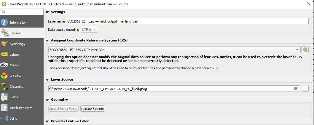
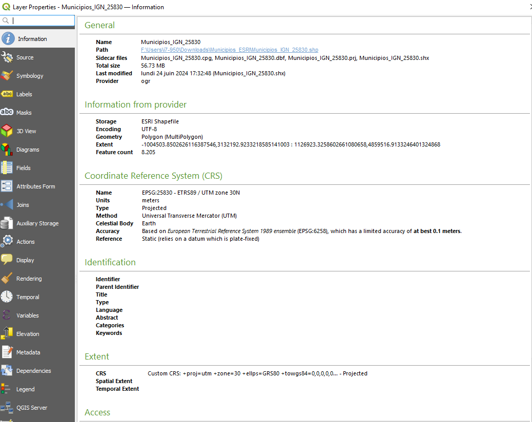
I have downloaded layers that contain information on the type of land cover (source: source of CLC layer). After importing in in QGIS (New Project>Browser>GeoPackage>New Connection>path to file) and then dropping the file in the Layers, I see the layer and its contents. At the bottom right, the CRS is EPSG:25830. In the Properties of the layer (right-click on the layer and click on Properties), I see that the CRS is EPSG:25830. (see the properties of the land cover layer: properties of the land cover layer and its assigned CRS: assigned CRS of the layer)
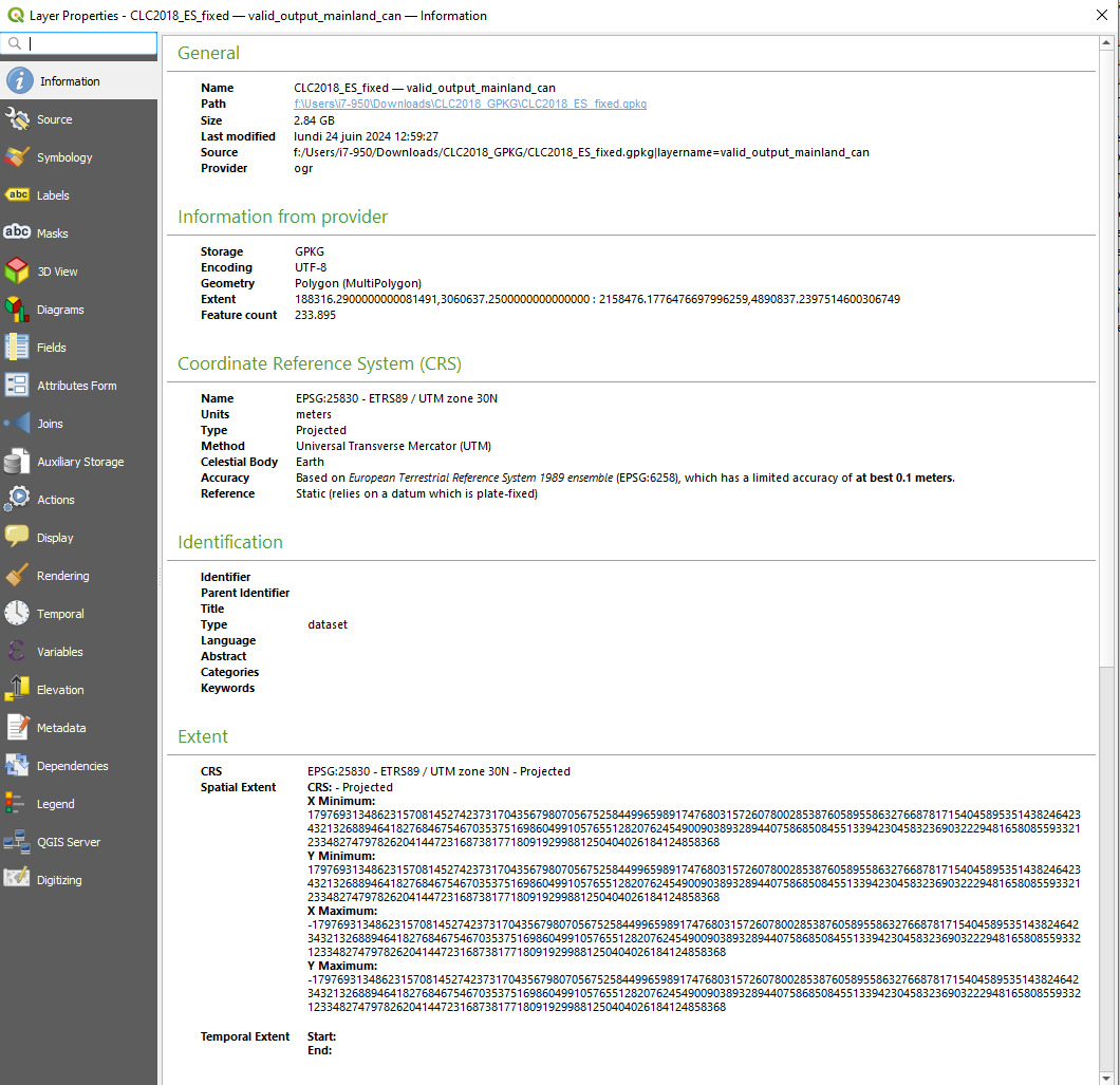
Now I want to overlay the limits of the municipalities. The SHP file comes from here. To check its coordinate system, I uploaded it to MyGeoCloud. Its reference system is WGS 84 / Pseudo-Mercator (EPSG:3857). If I import it into a new QGIS project, it displays that value too.

I have tried this:

  1. Import the land cover layer into a new project, then drop the municipalities => failed enter image description here
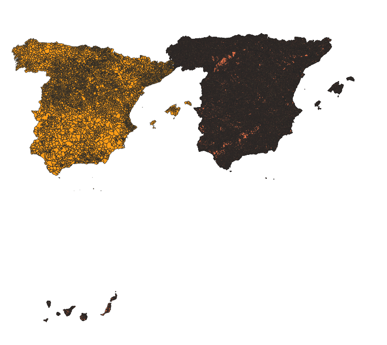
  2. Import the municipalities and then the land cover => failed enter image description here
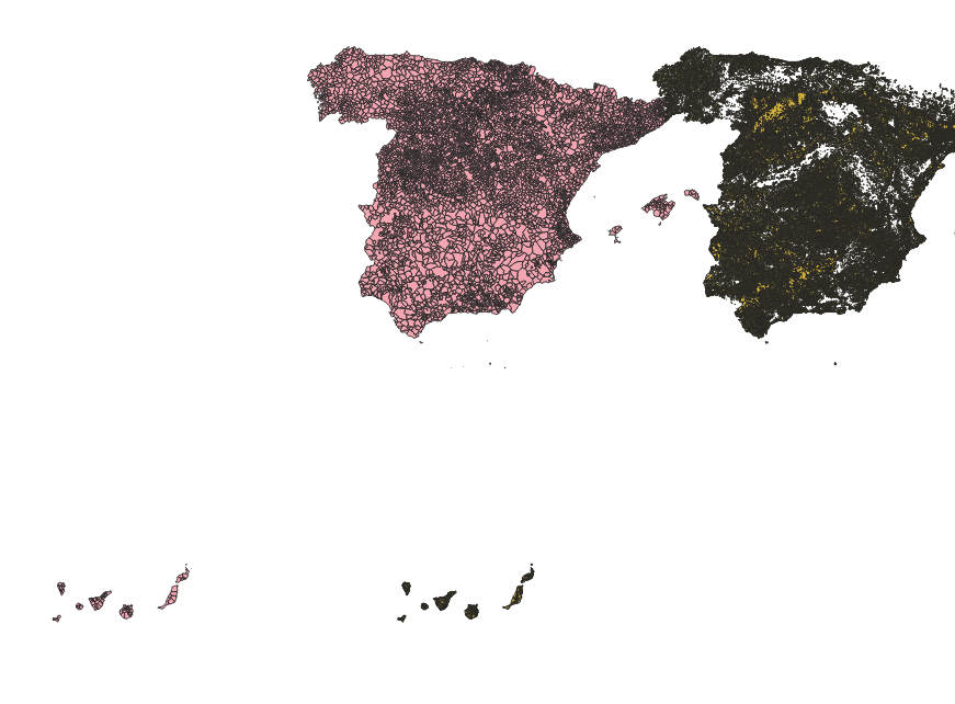
    However, I was under the impression that QGIS (I am using 3.36 Maiden) was able to adjust that.

  3. Reproject the shapefile before importing to the project => failed.

    Some answers here suggested reprojecting the layer (I will reproject the municipalities layer). So I did: New Project>Import the limits>Vector>Data Management Tools>Reproject Layer. I chose EPSG: 25830 as the Target CRS. I then export the layer by right-clicking on the layer>Export>Save Features As...> and I choose a name for that file. If I right-click on that exported layer, I see that the CRS of that layer is the one I want:

    enter image description here

I create a new project and drop the new shapefile with the CRS of 25830 and the CRS I want is at the bottom-right of QGIS.

I drop the layer of land cover onto that project and it does not match. enter image description here.
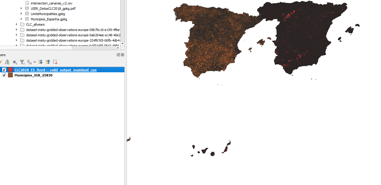
What do I do wrong? Could you list a workflow that would work?

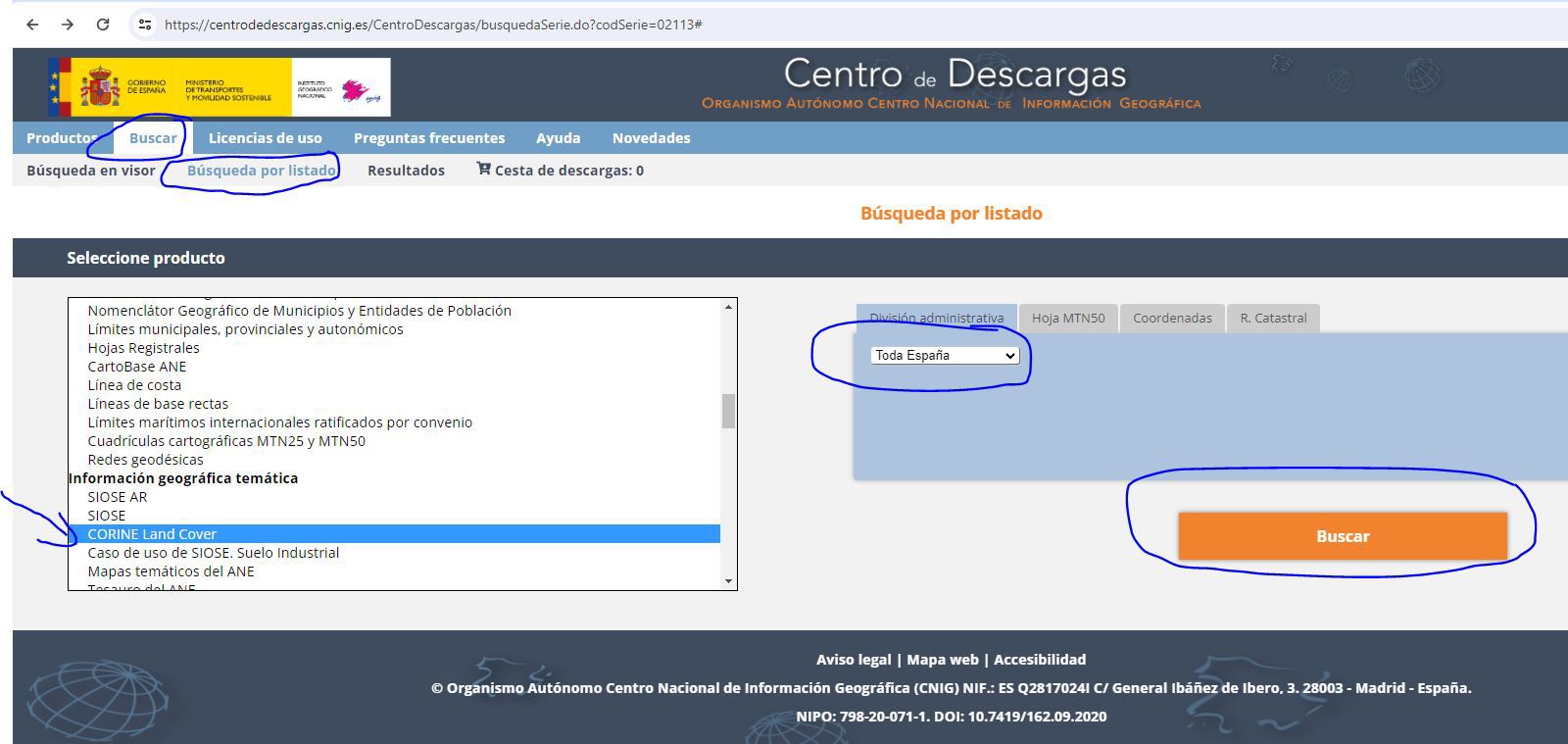
EDIT: steps to download the layers: Land cover layer:

  1. Go to this link and search ("Buscar") enter image description here,
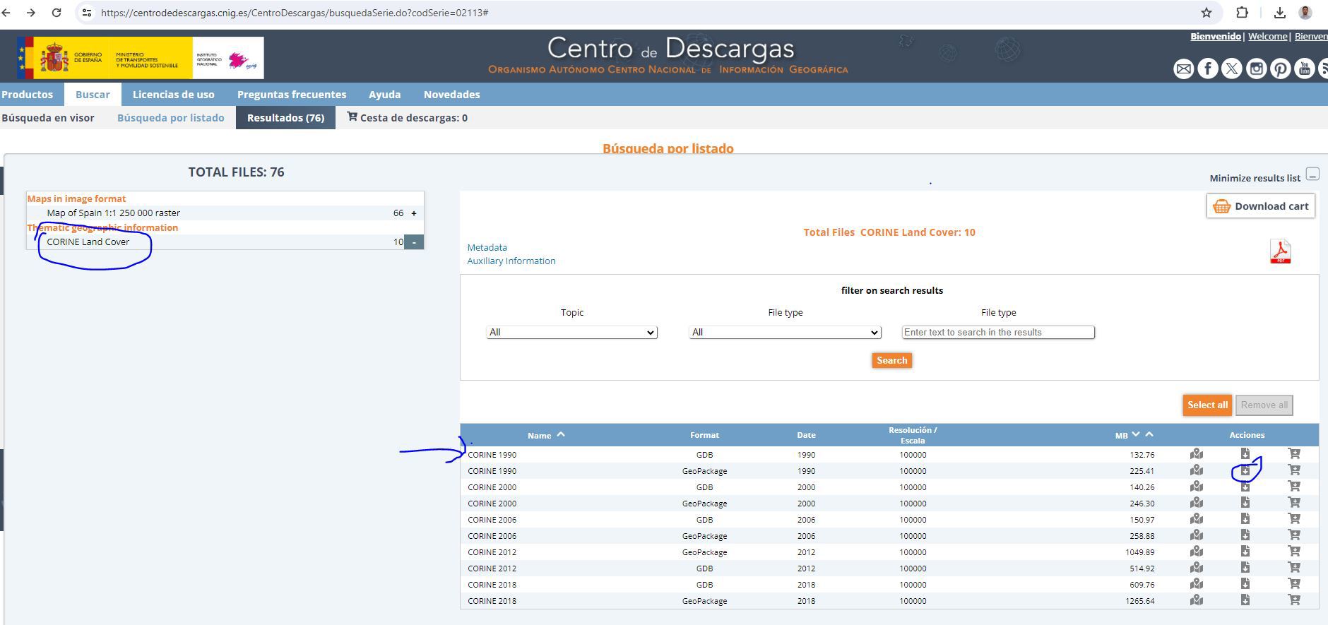
  2. then download the Geopackage file. enter image description here

SHP file of the municipalities:

  1. Go to this website (or search "municipios ign esri" on Google if the link does not work)
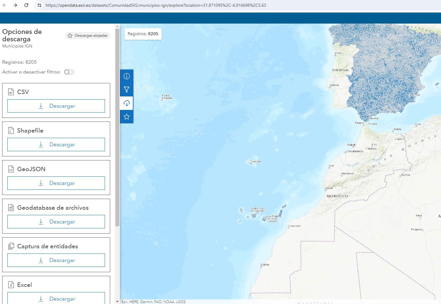
  2. Download as SHP enter image description here

This looks like an easy solution but, for the life of me, I cannot manage to solve this. I have browsed this website where solutions were provided but unfortunately, none have produced the desired outcome.

I am very novice in QGIS, so any solution provided should be very detailed.

I have downloaded layers that contain information on the type of land cover (source: source of CLC layer). After importing in in QGIS (New Project>Browser>GeoPackage>New Connection>path to file) and then dropping the file in the Layers, I see the layer and its contents. At the bottom right, the CRS is EPSG:25830. In the Properties of the layer (right-click on the layer and click on Properties), I see that the CRS is EPSG:25830. (see the properties of the land cover layer: properties of the land cover layer and its assigned CRS: assigned CRS of the layer)

Now I want to overlay the limits of the municipalities. The SHP file comes from here. To check its coordinate system, I uploaded it to MyGeoCloud. Its reference system is WGS 84 / Pseudo-Mercator (EPSG:3857). If I import it into a new QGIS project, it displays that value too.

I have tried this:

  1. Import the land cover layer into a new project, then drop the municipalities => failed enter image description here

  2. Import the municipalities and then the land cover => failed enter image description here

    However, I was under the impression that QGIS (I am using 3.36 Maiden) was able to adjust that.

  3. Reproject the shapefile before importing to the project => failed.

    Some answers here suggested reprojecting the layer (I will reproject the municipalities layer). So I did: New Project>Import the limits>Vector>Data Management Tools>Reproject Layer. I chose EPSG: 25830 as the Target CRS. I then export the layer by right-clicking on the layer>Export>Save Features As...> and I choose a name for that file. If I right-click on that exported layer, I see that the CRS of that layer is the one I want:

    enter image description here

I create a new project and drop the new shapefile with the CRS of 25830 and the CRS I want is at the bottom-right of QGIS.

I drop the layer of land cover onto that project and it does not match. enter image description here.

What do I do wrong? Could you list a workflow that would work?

EDIT: steps to download the layers: Land cover layer:

  1. Go to this link and search ("Buscar") enter image description here,
  2. then download the Geopackage file. enter image description here

SHP file of the municipalities:

  1. Go to this website (or search "municipios ign esri" on Google if the link does not work)
  2. Download as SHP enter image description here
added 15 characters in body; edited title
Source Link
Taras
  • 34k
  • 4
  • 73
  • 148

How to display Displaying two different layers in the same coordinate systems? in QGIS

This looks like an easy solution but, for the life of me, I cannot manage to solve this. I have browsed this website where solutions were provided but unfortunately, none have produced the desired outcome.

I am very novice in QGIS, so any solution provided should be very detailed.

I have downloaded layers that contain information on the type of land cover (source: source of CLC layer). After importing in in QGIS (New Project>Browser>GeoPackage>New Connection>path to file) and then dropping the file in the Layers, I see the layer and its contents. At the bottom right, the CRS is EPSG:25830. In the Properties of the layer (right-click on the layer and click on Properties), I see that the CRS is EPSG:25830. (see the properties of the land cover layer: properties of the land cover layer and its assigned CRS: assigned CRS of the layer)

Now I want to overlay the limits of the municipalities. The SHP file comes from here. To check its coordinate system, I uploaded it to MyGeoCloud. Its reference system is WGS 84 / Pseudo-Mercator (EPSG:3857). If I import it into a new QGIS project, it displays that value too.

I have tried this:

  1. Import the land cover layer into a new project, then drop the municipalities => failed

    Import the land cover layer into a new project, then drop the municipalities => failed enter image description here

    enter image description here
  2. Import the municipalities and then the land cover => failed

    Import the municipalities and then the land cover => failed enter image description here

    enter image description here

    However, I was under the impression that QGIS (I am using 3.36 Maiden) was able to adjust that.

  3. Reproject the shapefile before importing to the project => failed.

    Some answers here suggested reprojecting the layer (I will reproject the municipalities layer). So I did: New Project>Import the limits>Vector>Data Management Tools>Reproject Layer. I chose EPSG: 25830 as the Target CRS. I then export the layer by right-clicking on the layer>Export>Save Features As...> and I choose a name for that file. If I right-click on that exported layer, I see that the CRS of that layer is the one I want:

    enter image description here

However, I was under the impression that QGIS (I am using 3.36 Maiden) was able to adjust that.

  1. Reproject the shapefile before importing to the project => failed.

Some answers on here suggested reprojecting the layer (I will reproject the municipalities layer). So I did: New Project>Import the limits>Vector>Data Management Tools>Reproject Layer. I chose EPSG: 25830 as the Target CRS. I then export the layer by right-clicking on the layer>Export>Save Features As...> and I choose a name for that file. If I right-click on that exported layer, I see that the CRS of that layer is the one I want: enter image description here.

I create a new project and drop the new shapefile with the CRS of 25830 and the CRS I want is at the bottom-right of QGIS.

I drop the layer of land cover onto that project and it does not match. enter image description here.

What do I do wrong? Could you list a workflow that would work?

How to display two different layers in the same coordinate systems?

This looks like an easy solution but, for the life of me, I cannot manage to solve this. I have browsed this website where solutions were provided but unfortunately, none have produced the desired outcome.

I am very novice in QGIS, so any solution provided should be very detailed.

I have downloaded layers that contain information on the type of land cover (source: source of CLC layer). After importing in in QGIS (New Project>Browser>GeoPackage>New Connection>path to file) and then dropping the file in the Layers, I see the layer and its contents. At the bottom right, the CRS is EPSG:25830. In the Properties of the layer (right-click on the layer and click on Properties), I see that the CRS is EPSG:25830. (see the properties of the land cover layer: properties of the land cover layer and its assigned CRS: assigned CRS of the layer)

Now I want to overlay the limits of the municipalities. The SHP file comes from here. To check its coordinate system, I uploaded it to MyGeoCloud. Its reference system is WGS 84 / Pseudo-Mercator (EPSG:3857). If I import it into a new QGIS project, it displays that value too.

I have tried this:

  1. Import the land cover layer into a new project, then drop the municipalities => failed enter image description here
  2. Import the municipalities and then the land cover => failed enter image description here

However, I was under the impression that QGIS (I am using 3.36 Maiden) was able to adjust that.

  1. Reproject the shapefile before importing to the project => failed.

Some answers on here suggested reprojecting the layer (I will reproject the municipalities layer). So I did: New Project>Import the limits>Vector>Data Management Tools>Reproject Layer. I chose EPSG: 25830 as the Target CRS. I then export the layer by right-clicking on the layer>Export>Save Features As...> and I choose a name for that file. If I right-click on that exported layer, I see that the CRS of that layer is the one I want: enter image description here.

I create a new project and drop the new shapefile with the CRS of 25830 and the CRS I want is at the bottom-right of QGIS.

I drop the layer of land cover onto that project and it does not match. enter image description here.

What do I do wrong? Could you list a workflow that would work?

Displaying two different layers in the same coordinate systems in QGIS

This looks like an easy solution but, for the life of me, I cannot manage to solve this. I have browsed this website where solutions were provided but unfortunately, none have produced the desired outcome.

I am very novice in QGIS, so any solution provided should be very detailed.

I have downloaded layers that contain information on the type of land cover (source: source of CLC layer). After importing in in QGIS (New Project>Browser>GeoPackage>New Connection>path to file) and then dropping the file in the Layers, I see the layer and its contents. At the bottom right, the CRS is EPSG:25830. In the Properties of the layer (right-click on the layer and click on Properties), I see that the CRS is EPSG:25830. (see the properties of the land cover layer: properties of the land cover layer and its assigned CRS: assigned CRS of the layer)

Now I want to overlay the limits of the municipalities. The SHP file comes from here. To check its coordinate system, I uploaded it to MyGeoCloud. Its reference system is WGS 84 / Pseudo-Mercator (EPSG:3857). If I import it into a new QGIS project, it displays that value too.

I have tried this:

  1. Import the land cover layer into a new project, then drop the municipalities => failed enter image description here

  2. Import the municipalities and then the land cover => failed enter image description here

    However, I was under the impression that QGIS (I am using 3.36 Maiden) was able to adjust that.

  3. Reproject the shapefile before importing to the project => failed.

    Some answers here suggested reprojecting the layer (I will reproject the municipalities layer). So I did: New Project>Import the limits>Vector>Data Management Tools>Reproject Layer. I chose EPSG: 25830 as the Target CRS. I then export the layer by right-clicking on the layer>Export>Save Features As...> and I choose a name for that file. If I right-click on that exported layer, I see that the CRS of that layer is the one I want:

    enter image description here

I create a new project and drop the new shapefile with the CRS of 25830 and the CRS I want is at the bottom-right of QGIS.

I drop the layer of land cover onto that project and it does not match. enter image description here.

What do I do wrong? Could you list a workflow that would work?

removed thanks
Source Link
Vince
  • 20.3k
  • 16
  • 48
  • 65

This looks like an easy solution but, for the life of me, I cannot manage to solve this. I have browsed this website where solutions were provided but unfortunately, none have produced the desired outcome.

I am very novice in QGIS, so any solution provided should be very detailed.

I have downloaded layers that contain information on the type of land cover (source: source of CLC layer). After importing in in QGIS (New Project>Browser>GeoPackage>New Connection>path to file) and then dropping the file in the Layers, I see the layer and its contents. At the bottom right, the CRS is EPSG:25830. In the Properties of the layer (right-click on the layer and click on Properties), I see that the CRS is EPSG:25830. (see the properties of the land cover layer: properties of the land cover layer and its assigned CRS: assigned CRS of the layer)

Now I want to overlay the limits of the municipalities. The SHP file comes from here. To check its coordinate system, I uploaded it to MyGeoCloud. Its reference system is WGS 84 / Pseudo-Mercator (EPSG:3857). If I import it into a new QGIS project, it displays that value too.

I have tried this:

  1. Import the land cover layer into a new project, then drop the municipalities => failed enter image description here
  2. Import the municipalities and then the land cover => failed enter image description here

However, I was under the impression that QGIS (I am using 3.36 Maiden) was able to adjust that.

  1. Reproject the shapefile before importing to the project => failed.

Some answers on here suggested reprojecting the layer (I will reproject the municipalities layer). So I did: New Project>Import the limits>Vector>Data Management Tools>Reproject Layer. I chose EPSG: 25830 as the Target CRS. I then export the layer by right-clicking on the layer>Export>Save Features As...> and I choose a name for that file. If I right-click on that exported layer, I see that the CRS of that layer is the one I want: enter image description here.

I create a new project and drop the new shapefile with the CRS of 25830 and the CRS I want is at the bottom-right of QGIS.

I drop the layer of land cover onto that project and it does not match. enter image description here.

What do I do wrong? Could you list a workflow that would work?

Thanks a lot.

This looks like an easy solution but, for the life of me, I cannot manage to solve this. I have browsed this website where solutions were provided but unfortunately, none have produced the desired outcome.

I am very novice in QGIS, so any solution provided should be very detailed.

I have downloaded layers that contain information on the type of land cover (source: source of CLC layer). After importing in in QGIS (New Project>Browser>GeoPackage>New Connection>path to file) and then dropping the file in the Layers, I see the layer and its contents. At the bottom right, the CRS is EPSG:25830. In the Properties of the layer (right-click on the layer and click on Properties), I see that the CRS is EPSG:25830. (see the properties of the land cover layer: properties of the land cover layer and its assigned CRS: assigned CRS of the layer)

Now I want to overlay the limits of the municipalities. The SHP file comes from here. To check its coordinate system, I uploaded it to MyGeoCloud. Its reference system is WGS 84 / Pseudo-Mercator (EPSG:3857). If I import it into a new QGIS project, it displays that value too.

I have tried this:

  1. Import the land cover layer into a new project, then drop the municipalities => failed enter image description here
  2. Import the municipalities and then the land cover => failed enter image description here

However, I was under the impression that QGIS (I am using 3.36 Maiden) was able to adjust that.

  1. Reproject the shapefile before importing to the project => failed.

Some answers on here suggested reprojecting the layer (I will reproject the municipalities layer). So I did: New Project>Import the limits>Vector>Data Management Tools>Reproject Layer. I chose EPSG: 25830 as the Target CRS. I then export the layer by right-clicking on the layer>Export>Save Features As...> and I choose a name for that file. If I right-click on that exported layer, I see that the CRS of that layer is the one I want: enter image description here.

I create a new project and drop the new shapefile with the CRS of 25830 and the CRS I want is at the bottom-right of QGIS.

I drop the layer of land cover onto that project and it does not match. enter image description here.

What do I do wrong? Could you list a workflow that would work?

Source Link
Loading