added 5 characters in body; edited tags; edited title
Source Link
Taras
  • 34.1k
  • 4
  • 73
  • 148

Create a Creating directory tree of raster tiles from a GeoJSON using command line tools

This webmap shows raster tiles overlaid on OSM rastertiles. One such tile, for example the 10/508/336 tile looks like this:

I would like to create a directory of such tiles using command line tools. Here is an example of GeoJSON:

{
"type": "FeatureCollection",
"name": "source",
"crs": { "type": "name", "properties": { "name": "urn:ogc:def:crs:OGC:1.3:CRS84" } },
"features": [
{ "type": "Feature", "properties": { }, "geometry": { "type": "LineString", "coordinates": [ [ 4.90571755, 50.00687119 ], [ 4.26413271, 50.41744784 ], [ 3.53584721, 49.9399581 ], [ 3.54162726, 49.39377674 ], [ 4.36817349, 49.03887689 ], [ 4.9924182, 49.27701689 ], [ 5.00397829, 49.55902504 ], [ 4.36817349, 49.55527559 ] ] } }
]
}

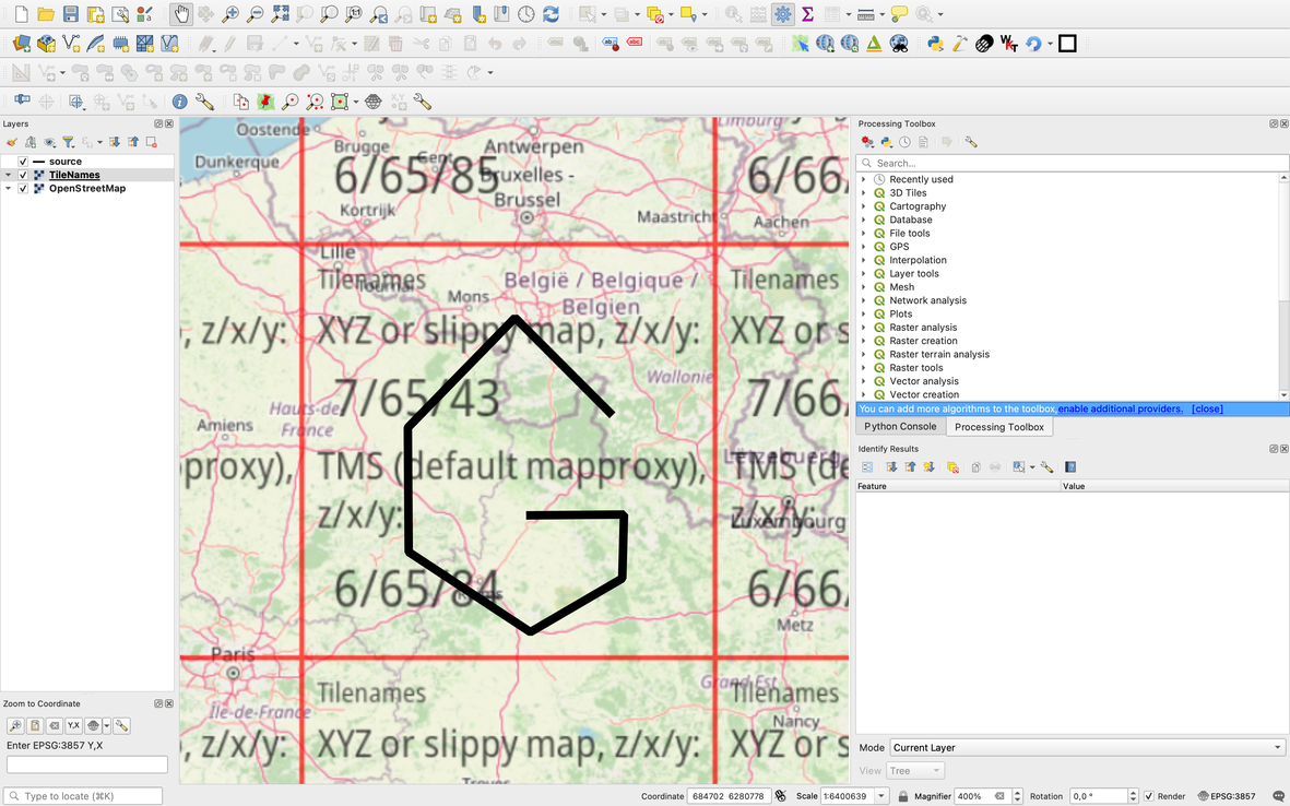
It covers the 7/65/43 tile:

enter image description here

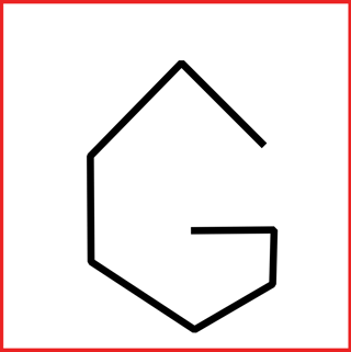
In the directory structure I would like to create, 7/65/43.png would look something like this (I left the red boundary, so it is easier to see where the boundary of the image is):

enter image description here

I know about tippecanoe, and vector tiles in general. Here, I am asking about raster tiles. In Directly generating XYZ tiles from GeoJSON, tippecanoe is suggested. In Converting GeoJSON file to XYZ tiles, QGIS is suggested. I would like to use command line tools. GDAL can do many things, I hope it can do this as well (but I'm open to other tools as well). I have read about gdal2xyzgdal2xyz, but the input is a raster file, not a vector file.

How to create a directory tree of raster tiles from a GeoJSON using command line tools?

Create a directory tree of raster tiles from a GeoJSON using command line tools

This webmap shows raster tiles overlaid on OSM rastertiles. One such tile, for example the 10/508/336 tile looks like this:

I would like to create a directory of such tiles using command line tools. Here is an example GeoJSON:

{
"type": "FeatureCollection",
"name": "source",
"crs": { "type": "name", "properties": { "name": "urn:ogc:def:crs:OGC:1.3:CRS84" } },
"features": [
{ "type": "Feature", "properties": { }, "geometry": { "type": "LineString", "coordinates": [ [ 4.90571755, 50.00687119 ], [ 4.26413271, 50.41744784 ], [ 3.53584721, 49.9399581 ], [ 3.54162726, 49.39377674 ], [ 4.36817349, 49.03887689 ], [ 4.9924182, 49.27701689 ], [ 5.00397829, 49.55902504 ], [ 4.36817349, 49.55527559 ] ] } }
]
}

It covers the 7/65/43 tile:

enter image description here

In the directory structure I would like to create, 7/65/43.png would look something like this (I left the red boundary, so it is easier to see where the boundary of the image is):

enter image description here

I know about tippecanoe, and vector tiles in general. Here, I am asking about raster tiles. In Directly generating XYZ tiles from GeoJSON, tippecanoe is suggested. In Converting GeoJSON file to XYZ tiles, QGIS is suggested. I would like to use command line tools. GDAL can do many things, I hope it can do this as well (but I'm open to other tools as well). I have read about gdal2xyz, but the input is a raster file, not a vector file.

How to create a directory tree of raster tiles from a GeoJSON using command line tools?
Creating directory tree of raster tiles from GeoJSON using command line tools

This webmap shows raster tiles overlaid on OSM rastertiles. One such tile, for example the 10/508/336 tile looks like this:

I would like to create a directory of such tiles using command line tools. Here is an example of GeoJSON:

{
"type": "FeatureCollection",
"name": "source",
"crs": { "type": "name", "properties": { "name": "urn:ogc:def:crs:OGC:1.3:CRS84" } },
"features": [
{ "type": "Feature", "properties": { }, "geometry": { "type": "LineString", "coordinates": [ [ 4.90571755, 50.00687119 ], [ 4.26413271, 50.41744784 ], [ 3.53584721, 49.9399581 ], [ 3.54162726, 49.39377674 ], [ 4.36817349, 49.03887689 ], [ 4.9924182, 49.27701689 ], [ 5.00397829, 49.55902504 ], [ 4.36817349, 49.55527559 ] ] } }
]
}

It covers the 7/65/43 tile:

enter image description here

In the directory structure I would like to create, 7/65/43.png would look something like this (I left the red boundary, so it is easier to see where the boundary of the image is):

enter image description here

I know about tippecanoe, and vector tiles in general. Here, I am asking about raster tiles. In Directly generating XYZ tiles from GeoJSON, tippecanoe is suggested. In Converting GeoJSON file to XYZ tiles, QGIS is suggested. I would like to use command line tools. GDAL can do many things, I hope it can do this as well (but I'm open to other tools as well). I have read about gdal2xyz, but the input is a raster file, not a vector file.

How to create a directory tree of raster tiles from a GeoJSON using command line tools?
added 5 characters in body; edited title
Source Link
zabop
  • 2.7k
  • 14
  • 41

Create a directory tree of raster tiles from a GeoJSON using command line tools

This webmap shows raster tiles overlaid on OSM rastertiles. One such tile, for example the 10/508/336 tile looks like this:

I would like to create a directory of such tiles using command line tools. Here is an example GeoJSON:

{
"type": "FeatureCollection",
"name": "source",
"crs": { "type": "name", "properties": { "name": "urn:ogc:def:crs:OGC:1.3:CRS84" } },
"features": [
{ "type": "Feature", "properties": { }, "geometry": { "type": "LineString", "coordinates": [ [ 4.90571755, 50.00687119 ], [ 4.26413271, 50.41744784 ], [ 3.53584721, 49.9399581 ], [ 3.54162726, 49.39377674 ], [ 4.36817349, 49.03887689 ], [ 4.9924182, 49.27701689 ], [ 5.00397829, 49.55902504 ], [ 4.36817349, 49.55527559 ] ] } }
]
}

It covers the 7/65/43 tile:

enter image description here

In the directory structure I would like to create, 7/65/43.png would look something like this (I left the red boundary, so it is easier to see where the boundary of the image is):

enter image description here

I know about tippecanoe, and vector tiles in general. Here, I am asking about raster tiles. In Directly generating XYZ tiles from GeoJSON, tippecanoe is suggested. In Converting GeoJSON file to XYZ tiles, QGIS is suggested. I would like to use command line tools. GDAL can do many things, I hope it can do this as well (but I'm open to other tools as well). I have read about gdal2xyz, but the input is a raster file, not a vector file.

How to create a directory tree of raster tiles from a GeoJSON using command line tools?

Create a directory of raster tiles from a GeoJSON using command line tools

This webmap shows raster tiles overlaid on OSM rastertiles. One such tile, for example the 10/508/336 tile looks like this:

I would like to create a directory of such tiles using command line tools. Here is an example GeoJSON:

{
"type": "FeatureCollection",
"name": "source",
"crs": { "type": "name", "properties": { "name": "urn:ogc:def:crs:OGC:1.3:CRS84" } },
"features": [
{ "type": "Feature", "properties": { }, "geometry": { "type": "LineString", "coordinates": [ [ 4.90571755, 50.00687119 ], [ 4.26413271, 50.41744784 ], [ 3.53584721, 49.9399581 ], [ 3.54162726, 49.39377674 ], [ 4.36817349, 49.03887689 ], [ 4.9924182, 49.27701689 ], [ 5.00397829, 49.55902504 ], [ 4.36817349, 49.55527559 ] ] } }
]
}

It covers the 7/65/43 tile:

enter image description here

In the directory structure I would like to create, 7/65/43.png would look something like this (I left the red boundary, so it is easier to see where the boundary of the image is):

enter image description here

I know about tippecanoe, and vector tiles in general. Here, I am asking about raster tiles. In Directly generating XYZ tiles from GeoJSON, tippecanoe is suggested. In Converting GeoJSON file to XYZ tiles, QGIS is suggested. I would like to use command line tools. GDAL can do many things, I hope it can do this as well (but I'm open to other tools as well). I have read about gdal2xyz, but the input is a raster file, not a vector file.

How to create a directory of raster tiles from a GeoJSON using command line tools?

Create a directory tree of raster tiles from a GeoJSON using command line tools

This webmap shows raster tiles overlaid on OSM rastertiles. One such tile, for example the 10/508/336 tile looks like this:

I would like to create a directory of such tiles using command line tools. Here is an example GeoJSON:

{
"type": "FeatureCollection",
"name": "source",
"crs": { "type": "name", "properties": { "name": "urn:ogc:def:crs:OGC:1.3:CRS84" } },
"features": [
{ "type": "Feature", "properties": { }, "geometry": { "type": "LineString", "coordinates": [ [ 4.90571755, 50.00687119 ], [ 4.26413271, 50.41744784 ], [ 3.53584721, 49.9399581 ], [ 3.54162726, 49.39377674 ], [ 4.36817349, 49.03887689 ], [ 4.9924182, 49.27701689 ], [ 5.00397829, 49.55902504 ], [ 4.36817349, 49.55527559 ] ] } }
]
}

It covers the 7/65/43 tile:

enter image description here

In the directory structure I would like to create, 7/65/43.png would look something like this (I left the red boundary, so it is easier to see where the boundary of the image is):

enter image description here

I know about tippecanoe, and vector tiles in general. Here, I am asking about raster tiles. In Directly generating XYZ tiles from GeoJSON, tippecanoe is suggested. In Converting GeoJSON file to XYZ tiles, QGIS is suggested. I would like to use command line tools. GDAL can do many things, I hope it can do this as well (but I'm open to other tools as well). I have read about gdal2xyz, but the input is a raster file, not a vector file.

How to create a directory tree of raster tiles from a GeoJSON using command line tools?

title as statement
Link
Vince
  • 20.3k
  • 16
  • 48
  • 65

How to create Create a directory of raster tiles from a GeoJSON using command line tools?

Source Link
zabop
  • 2.7k
  • 14
  • 41
Loading