added 152 characters in body
Source Link

I have data in an unknown projection to me.

I open it in QGIS and I see that the shapes are ok, but I need to identify the projection in order to merge this data with other stuff.

The points look like WGS84 (EPSG:4326) but without comma.

If a point in WGS84 is like this: (-58,-34)

In this projection the coordinates are something like: (5670000,6120000)

Any ideas?

EDIT: Here there are three pics, showing the situation.

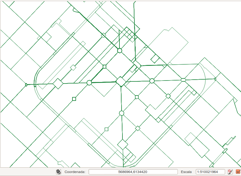
This is the data I'm trying to import, that i don't know what is the projection. Look at the point marked, it corresponds to the central square. Data I'm trying to import
This is my data (it is in lonlat even though it looks deformed). The coordinates shown are from the same central square. My data

This is google maps showing also the central square coordinates. google maps

SOLUTION image, transformed from Campo Inchauspe EPSG:22195 to lonlat. Thanks to mkennedy Solution

I have data in an unknown projection to me.

I open it in QGIS and I see that the shapes are ok, but I need to identify the projection in order to merge this data with other stuff.

The points look like WGS84 (EPSG:4326) but without comma.

If a point in WGS84 is like this: (-58,-34)

In this projection the coordinates are something like: (5670000,6120000)

Any ideas?

EDIT: Here there are three pics, showing the situation.

This is the data I'm trying to import, that i don't know what is the projection. Look at the point marked, it corresponds to the central square. Data I'm trying to import

This is my data (it is in lonlat even though it looks deformed). The coordinates shown are from the same central square. My data

This is google maps showing also the central square coordinates. google maps

SOLUTION image, transformed from Campo Inchauspe EPSG:22195 to lonlat. Thanks to mkennedy Solution

adding pics
Source Link

I have data in an unknown projection to me.

I open it in QGIS and I see that the shapes are ok, but I need to identify the projection in order to merge this data with other stuff.

The points look like WGS84 (EPSG:4326) but without comma.

If a point in WGS84 is like this: (-58,-34)

In this projection the coordinates are something like: (5670000,6120000)

Any ideas?

EDIT: Here there are three pics, showing the situation.

This is the data I'm trying to import, that i don't know what is the projection. Look at the point marked, it corresponds to the central square. Data I'm trying to import

This is my data (it is in lonlat even though it looks deformed). The coordinates shown are from the same central square. My data

This is google maps showing also the central square coordinates. google maps

I have data in an unknown projection to me.

I open it in QGIS and I see that the shapes are ok, but I need to identify the projection in order to merge this data with other stuff.

The points look like WGS84 (EPSG:4326) but without comma.

If a point in WGS84 is like this: (-58,-34)

In this projection the coordinates are something like: (5670000,6120000)

Any ideas?

EDIT: Here there are three pics, showing the situation.

This is the data I'm trying to import, that i don't know what is the projection. Look at the point marked, it corresponds to the central square. Data I'm trying to import

This is my data (it is in lonlat even though it looks deformed). The coordinates shown are from the same central square. My data

This is google maps showing also the central square coordinates. google maps

Source Link

how can I know which projection has this data?

I have data in an unknown projection to me.

I open it in QGIS and I see that the shapes are ok, but I need to identify the projection in order to merge this data with other stuff.

The points look like WGS84 (EPSG:4326) but without comma.

If a point in WGS84 is like this: (-58,-34)

In this projection the coordinates are something like: (5670000,6120000)

Any ideas?