typo
Source Link
AndreJ
  • 77.1k
  • 5
  • 88
  • 163

It is basically possible to do what you want, but not the easy way.

I did the following with QGIS:

Restricting the manipulation thto the northern hemisphere, I clipped the Natural Earth's land polygon and degree grid to positive values of latitude. Then I created a custom CRS for laea projection centered on the North Pole:

+proj=laea +lat_0=90 +lon_0=0 +x_0=0 +y_0=0 +ellps=GRS80 +towgs84=0,0,0,0,0,0,0 +units=m +no_defs

and reprojected the data to it.

In a second step, I created a similiar laea projection at 0°E/0°N:

+proj=laea +lat_0=0 +lon_0=0 +x_0=0 +y_0=0 +ellps=GRS80 +towgs84=0,0,0,0,0,0,0 +units=m +no_defs

and assigned it to the data from the last step. Note that I did not reproject the data to the new CRS in this step!

Then I reprojected that dataset back to WGS84, which puts the North pole into the middle of the Atlantic.

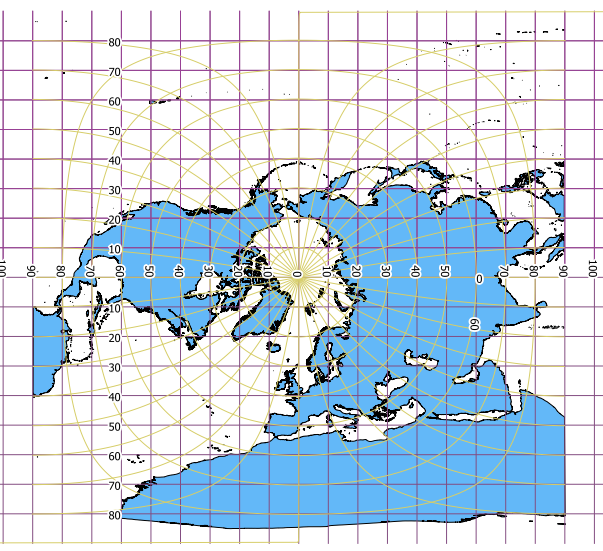
This is the picture I got:
enter image description here

I included the new degree grid in purple and the traditional grid in light green. The result is obviously useless around the equator, but should be usefull around the north pole.


EDIT

A very simple reprojection from Greenwich coordinates to North pole coordinates using a sphere would be:

En = (90°-Ng) * sin (Eg/180° * PI())
Nn = (Ng-90°) * cos (Eg/180° * PI())

With Eg and Ng degrees East and North in Greenwich coordinates (EPSG:4326) En and Nn degrees of a geographic Coordiante system centered at the north pole.

This will give you concentric circles for the Greenwich latitudes.

It is basically possible to do what you want, but not the easy way.

I did the following with QGIS:

Restricting the manipulation th the northern hemisphere, I clipped the Natural Earth's land polygon and degree grid to positive values of latitude. Then I created a custom CRS for laea projection centered on the North Pole:

+proj=laea +lat_0=90 +lon_0=0 +x_0=0 +y_0=0 +ellps=GRS80 +towgs84=0,0,0,0,0,0,0 +units=m +no_defs

and reprojected the data to it.

In a second step, I created a similiar laea projection at 0°E/0°N:

+proj=laea +lat_0=0 +lon_0=0 +x_0=0 +y_0=0 +ellps=GRS80 +towgs84=0,0,0,0,0,0,0 +units=m +no_defs

and assigned it to the data from the last step. Note that I did not reproject the data to the new CRS in this step!

Then I reprojected that dataset back to WGS84, which puts the North pole into the middle of the Atlantic.

This is the picture I got:

enter image description here

I included the new degree grid in purple and the traditional grid in light green. The result is obviously useless around the equator, but should be usefull around the north pole.


EDIT

A very simple reprojection from Greenwich coordinates to North pole coordinates using a sphere would be:

En = (90°-Ng) * sin (Eg/180° * PI())
Nn = (Ng-90°) * cos (Eg/180° * PI())

With Eg and Ng degrees East and North in Greenwich coordinates (EPSG:4326) En and Nn degrees of a geographic Coordiante system centered at the north pole.

This will give you concentric circles for the Greenwich latitudes.

It is basically possible to do what you want, but not the easy way.

I did the following with QGIS:

Restricting the manipulation to the northern hemisphere, I clipped the Natural Earth's land polygon and degree grid to positive values of latitude. Then I created a custom CRS for laea projection centered on the North Pole:

+proj=laea +lat_0=90 +lon_0=0 +x_0=0 +y_0=0 +ellps=GRS80 +towgs84=0,0,0,0,0,0,0 +units=m +no_defs

and reprojected the data to it.

In a second step, I created a similiar laea projection at 0°E/0°N:

+proj=laea +lat_0=0 +lon_0=0 +x_0=0 +y_0=0 +ellps=GRS80 +towgs84=0,0,0,0,0,0,0 +units=m +no_defs

and assigned it to the data from the last step. Note that I did not reproject the data to the new CRS in this step!

Then I reprojected that dataset back to WGS84, which puts the North pole into the middle of the Atlantic.

This is the picture I got:

enter image description here

I included the new degree grid in purple and the traditional grid in light green. The result is obviously useless around the equator, but should be usefull around the north pole.


EDIT

A very simple reprojection from Greenwich coordinates to North pole coordinates using a sphere would be:

En = (90°-Ng) * sin (Eg/180° * PI())
Nn = (Ng-90°) * cos (Eg/180° * PI())

With Eg and Ng degrees East and North in Greenwich coordinates (EPSG:4326) En and Nn degrees of a geographic Coordiante system centered at the north pole.

This will give you concentric circles for the Greenwich latitudes.

added 309 characters in body
Source Link
AndreJ
  • 77.1k
  • 5
  • 88
  • 163

It is basically possible to do what you want, but not the easy way.

I did the following with QGIS:

Restricting the manipulation th the northern hemisphere, I clipped the Natural Earth's land polygon and degree grid to positive values of latitude. Then I created a custom CRS for laea projection centered on the North Pole:

+proj=laea +lat_0=90 +lon_0=0 +x_0=0 +y_0=0 +ellps=GRS80 +towgs84=0,0,0,0,0,0,0 +units=m +no_defs

and reprojected the data to it.

In a second step, I created a similiar laea projection at 0°E/0°N:

+proj=laea +lat_0=0 +lon_0=0 +x_0=0 +y_0=0 +ellps=GRS80 +towgs84=0,0,0,0,0,0,0 +units=m +no_defs

and assigned it to the data from the last step. Note that I did not reproject the data to the new CRS in this step!

Then I reprojected that dataset back to WGS84, which puts the North pole into the middle of the Atlantic.

This is the picture I got:

enter image description here

I included the new degree grid in purple and the traditional grid in light green. The result is obviously useless around the equator, but should be usefull around the north pole.


Maybe you get the same result usingEDIT

A very simple trigonometric functions. It's just a definitionreprojection from Greenwich coordinates to set 0°North pole coordinates using a sphere would be:

En = (90°-Ng) * sin (Eg/180° * PI())
Nn = (Ng-90°) * cos (Eg/180° * PI())

With Eg and 90° to some points onNg degrees East and North in Greenwich coordinates (EPSG:4326) En and Nn degrees of a geographic Coordiante system centered at the spherenorth pole.

This will give you concentric circles for the Greenwich latitudes.

It is basically possible to do what you want, but not the easy way.

I did the following with QGIS:

Restricting the manipulation th the northern hemisphere, I clipped the Natural Earth's land polygon and degree grid to positive values of latitude. Then I created a custom CRS for laea projection centered on the North Pole:

+proj=laea +lat_0=90 +lon_0=0 +x_0=0 +y_0=0 +ellps=GRS80 +towgs84=0,0,0,0,0,0,0 +units=m +no_defs

and reprojected the data to it.

In a second step, I created a similiar laea projection at 0°E/0°N:

+proj=laea +lat_0=0 +lon_0=0 +x_0=0 +y_0=0 +ellps=GRS80 +towgs84=0,0,0,0,0,0,0 +units=m +no_defs

and assigned it to the data from the last step. Note that I did not reproject the data to the new CRS in this step!

Then I reprojected that dataset back to WGS84, which puts the North pole into the middle of the Atlantic.

This is the picture I got:

enter image description here

I included the new degree grid in purple and the traditional grid in light green. The result is obviously useless around the equator, but should be usefull around the north pole.

Maybe you get the same result using simple trigonometric functions. It's just a definition to set 0° and 90° to some points on the sphere.

It is basically possible to do what you want, but not the easy way.

I did the following with QGIS:

Restricting the manipulation th the northern hemisphere, I clipped the Natural Earth's land polygon and degree grid to positive values of latitude. Then I created a custom CRS for laea projection centered on the North Pole:

+proj=laea +lat_0=90 +lon_0=0 +x_0=0 +y_0=0 +ellps=GRS80 +towgs84=0,0,0,0,0,0,0 +units=m +no_defs

and reprojected the data to it.

In a second step, I created a similiar laea projection at 0°E/0°N:

+proj=laea +lat_0=0 +lon_0=0 +x_0=0 +y_0=0 +ellps=GRS80 +towgs84=0,0,0,0,0,0,0 +units=m +no_defs

and assigned it to the data from the last step. Note that I did not reproject the data to the new CRS in this step!

Then I reprojected that dataset back to WGS84, which puts the North pole into the middle of the Atlantic.

This is the picture I got:

enter image description here

I included the new degree grid in purple and the traditional grid in light green. The result is obviously useless around the equator, but should be usefull around the north pole.


EDIT

A very simple reprojection from Greenwich coordinates to North pole coordinates using a sphere would be:

En = (90°-Ng) * sin (Eg/180° * PI())
Nn = (Ng-90°) * cos (Eg/180° * PI())

With Eg and Ng degrees East and North in Greenwich coordinates (EPSG:4326) En and Nn degrees of a geographic Coordiante system centered at the north pole.

This will give you concentric circles for the Greenwich latitudes.

Source Link
AndreJ
  • 77.1k
  • 5
  • 88
  • 163

It is basically possible to do what you want, but not the easy way.

I did the following with QGIS:

Restricting the manipulation th the northern hemisphere, I clipped the Natural Earth's land polygon and degree grid to positive values of latitude. Then I created a custom CRS for laea projection centered on the North Pole:

+proj=laea +lat_0=90 +lon_0=0 +x_0=0 +y_0=0 +ellps=GRS80 +towgs84=0,0,0,0,0,0,0 +units=m +no_defs

and reprojected the data to it.

In a second step, I created a similiar laea projection at 0°E/0°N:

+proj=laea +lat_0=0 +lon_0=0 +x_0=0 +y_0=0 +ellps=GRS80 +towgs84=0,0,0,0,0,0,0 +units=m +no_defs

and assigned it to the data from the last step. Note that I did not reproject the data to the new CRS in this step!

Then I reprojected that dataset back to WGS84, which puts the North pole into the middle of the Atlantic.

This is the picture I got:

enter image description here

I included the new degree grid in purple and the traditional grid in light green. The result is obviously useless around the equator, but should be usefull around the north pole.

Maybe you get the same result using simple trigonometric functions. It's just a definition to set 0° and 90° to some points on the sphere.