The error depends on the distortions in the projection and on the terrain itself. Locally, over a small region, all projection distortions on the earth's surface amount to a stretch in one direction compared a perpendicular direction: this is why a (properly computed) Tissot Indicatrix is a perfect ellipse, because an ellipse is just a stretched circle. The terrain can have any combination of slope and aspect (flow direction). To handle this, let's look at a terrain that indeed has one point of everypoints in all possible such combinationdirections with simple flow lines: a a hemispherecone.


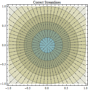
Overlaid on this color-shaded contour map of hemispherecone elevation is a collection of streamlines showing the directions where water would flow. You can confirm these streamlines are correct by checking that they cross the contours at right angles.
By choosing appropriate units of measurement and an appropriate origin for the coordinate system (at the hemisphere's centercone's apex), the equation for the elevation in terms of coordinates (x,y) is simply
z = Sqrt-Sqrt(x^2 + y^2).
The streamlines are always parallel to the gradient of z (in the reverse direction), computed by differentiating this formula with respect to x and y:
Grad-Grad(z) = (x, y) / Sqrt(x^2 + y^2).


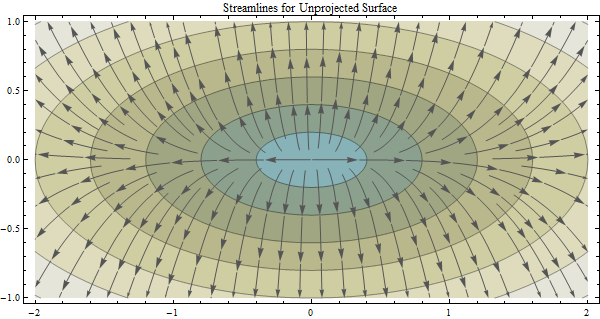
The effect of a twofold horizontal stretch in the coordinates (by a factor of 2 in this image) is to stretch all contours (without changing the contour levels: heights are not affected by projections). Although (of course) the contours represent true circles, they no longer look like true circles on the map. Nevertheless, when the streamlines are computed in these coordinates, they must cross the contours at right angles just as before.
z = Sqrt-Sqrt((x/stretch)^2 + y^2).
Grad-Grad(z) = (x/stretch^2, y) / Sqrt((x/stretch)^2 + y^2).


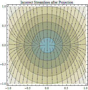
This third image reprojects the previous picture. The surface is shown once more without distortion. However, the streamlines no longer appear to cross the contours at right angles. This was the case even in the previous picture: due to the distortion therein, the angles only appeared to be right angles. The crossings were incorrect all along. That's why not projecting (or using a nonconformal projection) is a mistake. That's why not projecting (or using a nonconformal projection) is a mistake. The question is how big a mistake it might be. Some have claimed it's of little consequence (at least at low to moderate latitudes).
This reprojection (to remove distortion in the map) moves the point at (x*stretch, y) back to (x,y). The stream direction previously computed at this point was stored in a grid (as an angle or a direction code): it does not change. Therefore the computed stream direction at (x,y) is (x/stretch^2, y).
Reprojection affects directions differently depending on how the flow is oriented with respect to the major axis of the Tissot Indicatrix. It is a quadratic function of the relative linear distortion in the projection. As such, it exaggerates even slight amounts of distortion. (The factor of two illustrated here is somewhat extreme but realistic: it is the distortion introduced by failing to project--that is, using geographic coordinates as map coordinates--at latitudes of 60 degrees.)