1

A coworker of mine has a bunch of well data (including georeferencing and attribute tables) in IHS Kingdom. We need to convert this data into a format that works with ArcGIS (e.g. .shp files). Unfortunately, it looks like the only options for exporting are as follows:

.wtv2 - Tobin Well

.asc - Landmark Well 2.x/3.x .asc - Landmark Well OWX

.wel - Charisma

.gds - GDSII

.dat - Well Production Data

As far as I can tell, none of these are compatible, and each of them are extremely poorly documented online. As is Kingdom IHS, for that matter.

The only solution we've managed so far would be to export the map as a large PDF before georectifying and manually digitizing each of the wells in ArcGIS. However, there are too many wells to make this a viable option.

3
  • Are any of these text format? If it can be opened in notepad you can usually tell what's going on and create a python tool to create a shape file... as long as the format is text and not binary. Commented Jun 6, 2014 at 2:12
  • Forget IHS ;) psg.deloitte.co.uk/ProductsPetroView.asp
    – pvdev
    Commented Jun 6, 2014 at 8:27
  • Have a look at Exprodat's Data Assistant: exprodat.com/Software/TGDA it is a good interoperability tool and transfers Kingdom data to ArcGIS fromat rapidly and easily.
    – spk578
    Commented Jun 30, 2015 at 20:14

2 Answers 2

2

Unfortunately this is a closed proprietary system with non-open file formats.

To convert IHS Kingdom to shapefile use the conversion software below.

http://www.exprodat.com/Software/TGDA/

They do free trials.

0
0

The solution is the following:

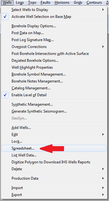
  • in the Menu, under the "Wells" option there is "Spreadsheet" item.

Spreadsheet menu item

Here you can export all the data you need in text format, what can be converted and displayed in ArcGIS.

Your Answer

By clicking “Post Your Answer”, you agree to our terms of service and acknowledge you have read our privacy policy.

Not the answer you're looking for? Browse other questions tagged or ask your own question.