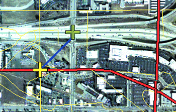
I am trying to georeference a newly acquired satellite image to a previously georeferenced image, i.e. match the newer raster to the older one with manually or automatically created control points. I'm trying to work out whether these control points are created by first selecting a point on the georeferenced raster (or vector), then the corresponding point on the unreferenced raster, or is it the other way around. Or when I automatically generate points, which are the red and green crosses?
There is little detail in the help pages for ArcGIS. The most info I can find is this (my emphasis):
The connection between one control point on the raster dataset (the from point) and the corresponding control point on the aligned target data (the to point) is a link.
The example below shows a from control point (yellow cross) placed on the vector target data at a street crossing and the associated control point (green cross) placed on the raster dataset.
Source: Fundamentals of georeferencing a raster dataset
Is it just me or are those definitions of the from and to points contradictory? What is correct?

