8

I'm trying to export some images of Gulf of Mexico infrastructure that will later be used for non-GIS purposes as overlays onto sea current/weather maps (likely in photoshop).

I have no clue how to do this in either Arc or in QGIS. My student version of Arc just ran out but I still have access to Arc through school if there's an easy solution there ( I suppose Arc might have an "easy" solution).

I would rather a QGIS solution though as it is more sustainable for me in the long run. I have seen how to have a transparent background in the Print Composer background, but this doesn't help me when I add map data to the composer as the map data is imported into the composer with a white background.

Any tips? Maybe a way to change the background color of QGIS itself to transparent?

PS: To clarify, I'm looking to export with transparency, not have transparency in the program. Also, if it matters, the layers are vectors.

4
  • Walt, whether you're using georeferenced data or not by overlaying (yes, even in Photoshop) it's still GIS. I can remember doing a project that involved drawing on acetate sheets from photos taken from a plane (just hanging out the door, not true air photography) and that was still GIS. Commented Nov 26, 2014 at 5:37
  • Are you definitely going to be using Photoshop? What are the likely steps and final output going to be? I'm curious as to whether a vector output might be usable.
    – Simbamangu
    Commented Nov 26, 2014 at 8:40
  • Michael: Thanks for reminding me that I'm still being a geospatial scientist, even in photoshop :) I might disagree if my boss tells me to do something in MSPaint though...
    – WClark97
    Commented Dec 4, 2014 at 4:59
  • Simbamangu: I do environmental consulting for the energy sector (first job, couldnt say no, etc). There's little software here to address spatial needs. Most of our graphics (spatial and otherwise) are done in Photoshop 4. One of my boss's duties is to do a subsurface current analysis. He gets the data from somewhere as static images, but a client asked if some spatial data could be added. Since we aren't natively in spatial software, he asked if i could create a graphic of the requested data that he could just throw on top of his analysis in PS 4 and then export off to client.
    – WClark97
    Commented Dec 4, 2014 at 5:00

2 Answers 2

16

This is possible in QGIS using the print composer. You'll need to both:

  1. Remove the background color from the map item. This is done by unchecking the "background" option in the map item's properties. (The default is a white background)

  2. Set the page itself to a transparent style. This is done through the composition properties tab.

2
  • Thank you so much. Even though I'm still slugging through finding the QGIS way of doing what seems (to the QGIS uninitiated) to be simple actions in Arc, these instructions were simple and worked like a charm.
    – WClark97
    Commented Dec 4, 2014 at 5:01
  • Is there a quick way of getting the bounds of the exported image?
    – user15741
    Commented Apr 7, 2017 at 19:34
4

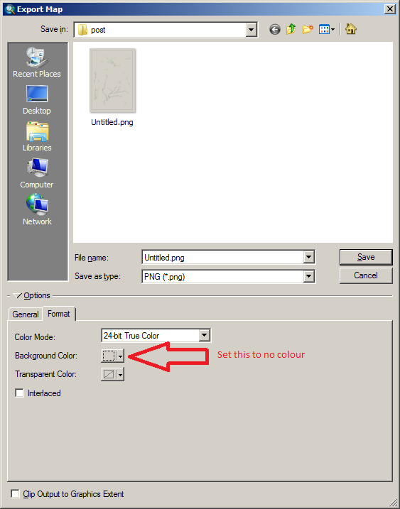
Arcmap has the ability to save with transparent colour for those image formats that support a transparent colour: GIF and PNG, of these two the PNG (Portable Network Graphic) is the better format as it supports 24bit colour and transparency where GIF only has 8bit palette colour and transparency.

To make the export transparent select in the export dialog (File::Export) Export Dialog

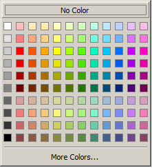
On the colour dialog:

Colour selector

Pick the large box at the top that says 'no colour' and the PNG will be exported with a transparent background.

Your Answer

By clicking “Post Your Answer”, you agree to our terms of service and acknowledge you have read our privacy policy.

Not the answer you're looking for? Browse other questions tagged or ask your own question.