I need help getting multiprocessing to work with the spatial analyst tool - Solar Analyst.
I have tested the multiprocessing bit and it works fine. This sample is passing it a file containing 2 lines used as parameters that get parsed and fed to the main function (final) as vars to the Solar Analyst tool. The function works on its own, but when altogether with the multiprocessing code I get the traceback below.
I think that the fact the raster DEM is trying to be accessed by multiple child processes is what is tripping the traceback error, as I get the error after some time, close to what would be the second run from the pool. Perhaps it is because I do not have unique scratch workspaces for each child process, as is mentioned in the following links: link1 link2. Again, if this is the case I need help implementing a unique workspace for each child process.
However, as suggested by a colleague I have successfully run the Solar Analyst tool using the same input raster on two instances of ArcMap being open, at the same time. So I am not convinced it is having a hard time accessing the raster because the other child process is as well. Thoughts?
In general, please feel free to offer any pointers you might have for optimizing this code.
import multiprocessing
import time
import arcpy

def final(x):
    outputfile=open("outputfile.txt","a")
    starttime= time.time()
    # Check out any necessary licenses
    arcpy.CheckOutExtension("Spatial")
    arcpy.env.workspace = r"C:\data\LiDAR\working\V2\FINAL_TEST\final_test"
    arcpy.env.overwriteOutput = True

    # Parse params
    the_split= x.split(",")
    DOY = the_split[0]
    k_daily = the_split[1]
    diffuse = the_split[2]


    # Set local variables
    inRaster = r"C:\data\LiDAR\working\V2\best_dems_05_1\oak_idwnat_flt.tif"
    latitude = 48.4222
    skySize = 400
    timeConfig = arcpy.sa.TimeWithinDay(DOY,0, 24)
    dayInterval = 14
    hourInterval = 0.5
    zFactor = 1
    calcDirections = 32
    zenithDivisions = 16
    azimuthDivisions = 16
    diffuseProp = diffuse
    transmittivity = k_daily
    outDirectRad = ""
    outDiffuseRad = ""
    outDirectDur = ""

    # Execute AreaSolarRadiation
    outGlobalRad = arcpy.sa.AreaSolarRadiation(inRaster, latitude, skySize, timeConfig,
       dayInterval, hourInterval, "NOINTERVAL", zFactor, "FROM_DEM",
       calcDirections, zenithDivisions, azimuthDivisions, "UNIFORM_SKY",
       diffuseProp, transmittivity, outDirectRad, outDiffuseRad, outDirectDur)

    # Save the output
    outGlobalRad.save(r"C:\data\LiDAR\working\V2\FINAL_TEST\output\global_"+str(DOY))
    end_time = time.time()
    outputfile.write("batch job" + str(DOY) + "ended well")
    outputfile.write(" %d " % (end_time-starttime) )
    outputfile.close()
#To test this script only pass the below
#if __name__ == "__main__":
#   final("266,0.4269347,0.771440152")

if __name__=='__main__':

    start= time.time()

    filename = "k_daily_diffuse_2.txt"
    readfile = open(filename, "r")
    lines_from_filename = []
    for i in readfile:
        lines_from_filename.append(i)
    p = multiprocessing.Pool(2)
    p.map(final, lines_from_filename)
    end = time.time()
    print "batch job ended well"
    print end-start

    p.close()
    p.join()
----------------------------------------OUTPUT BELOW----------------------------------------
Python 2.7.5 (default, May 15 2013, 22:44:16) [MSC v.1500 64 bit (AMD64)] on win32 Type "copyright", "credits" or "license()" for more information.
>>> ================================ RESTART ================================
>>>

Traceback (most recent call last):
File "C:\data\LiDAR\working\V2\FINAL_TEST\multi_test_FINAL.py", line 63, in <module>
        p.map(final, lines_from_filename)
File "C:\Python27\ArcGISx6410.2\lib\multiprocessing\pool.py", line 250, in map
        return self.map_async(func, iterable, chunksize).get()
File "C:\Python27\ArcGISx6410.2\lib\multiprocessing\pool.py", line 554, in get
        raise self._value ExecuteError:
ERROR 999999: Error executing function.
Failed to open raster dataset
Failed to execute (AreaSolarRadiation).
These sites report the same traceback errors, if they offer any clues: GeoNet from 2010 , GeoNet from 2014 , GIS StackExchange
-----------------------UPDATE-------UPDATE--------UPDATE------------------------------------
A clue!
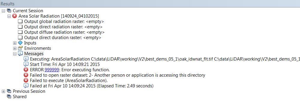
Following a suggestion by Nathan at Riverside I opened up two instances of ArcCatalog and ran the solar analyst tool using the same input raster at the same time. I got the following error:
 This explains the "Cannot open raster" traceback.
My initial thought is to have a unique copy of the input raster available for each run of the child process. Thoughts?
