2

I have over 50 csv files that have the same data structure and I need to merge them into one table.

As I need to build a model I have successfully imported all the files into a File Geodatabase.

How to I merge all these files into one table?
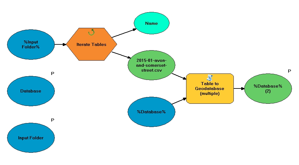
https://i.sstatic.net/wrsHw.jpg

3
  • Which type of geodatabase are you using? Commented Apr 27, 2015 at 12:59
  • I'm using FileGeodatabase
    – GeoMeteoMe
    Commented Apr 27, 2015 at 13:00
  • 1
    Check out the Append tool... that should be all you need.
    – mr.adam
    Commented Apr 27, 2015 at 13:29

4 Answers 4

2

You may use the Merge tool:

Combines multiple input datasets of the same data type into a single, new output dataset. This tool can combine point, line, or polygon feature classes or tables.

Open you model drag in the Merge tool, double click on in and add the many gdb tables within the input parameter, define out name and location, and then save model.

4
  • I need to build a model. I need to be able automatically merge or append 50 tables. Is it possible to use table iterator with append or merge?
    – GeoMeteoMe
    Commented Apr 27, 2015 at 13:42
  • 1
    This sounds like a new question. I would suggest to post as a new question.
    – artwork21
    Commented Apr 27, 2015 at 15:26
  • Sounds like the same question to me, but then I have a feeling the image wasn't included at the time the answer was made. @GeoMeteoMe Exposing the merge input as a parameter instead of hardcoding the list of tables might solve the problem. Otherwise the pictured model would need to be turned into a separate or sub model, and a new model created for the merge portion of things that would iterate tables in the geodatabase instead of a folder (in which case Append might be better than Merge).
    – Chris W
    Commented Apr 27, 2015 at 21:15
  • Thanks for your help. I tried to expose Merge parameter but it allows me to select only one table and I need to be able to select 50 tables.
    – GeoMeteoMe
    Commented May 6, 2015 at 14:17
0

you can

  1. add two fields in your table as x and y.
  2. you must append number in this fields(such as 1 & 2)
  3. in arc map _right click in your table and select display x , y data you can see your points in arc map
  4. merge all point layers and open attribute of new layer
1
  • Welcome to GIS SE! As a new user be sure to take the Tour to learn about our focussed Q&A format. The question is about ModelBuilder but your answer makes no mention of it.
    – PolyGeo
    Commented Aug 20, 2017 at 8:12
0

You don't need to do this in the Model builder, once you have your tables in your geo-database, just run the merge tool from outside on the geo-database.

To select all the tables under "Input Datasets" go to the directory where all your files are, then select the first file, hold down shift, and then select the last file, then click OK. This will load all the files into the merge tool.

0

You can use Join Tool in Model Builder.

Folder>Iterate Table>JoinTool

Make sure you have a temp table as input table and a column with similar content. enter image description here

Your Answer

By clicking “Post Your Answer”, you agree to our terms of service and acknowledge you have read our privacy policy.

Not the answer you're looking for? Browse other questions tagged or ask your own question.