Where can I acquire global wind (speed and direction) data?
Preferably in some kind of GIS format and free of charge.
Where can I acquire global wind (speed and direction) data?
Preferably in some kind of GIS format and free of charge.
The available free gridded global data mostly relates to near-surface wind speed and direction over global oceans. Free global land surface wind speed datasets are few.
None that I know come in GIS format, as each cell has two data values, one for speed and one for vector - but more digging might provide disaggregation and the possibility of mapping at least speed as a raster dataset in GIS.
For ocean data, there are various satellite scatterometer datasets. Try:
QuikSCAT: http://www.remss.com/missions/qscat; https://climatedataguide.ucar.edu/climate-data/quikscat-near-sea-surface-wind-speed-and-direction; http://podaac.jpl.nasa.gov/dataset/QSCAT_LEVEL_2B_OWV_COMP_12?ids=Collections&values=QUIKSCAT
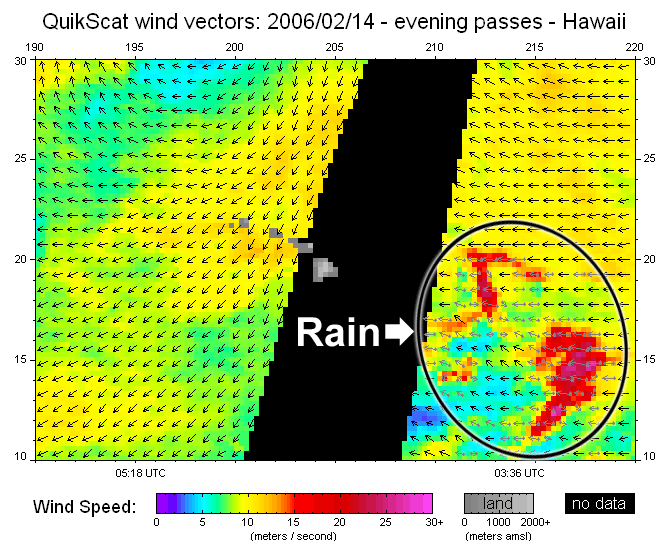
Here is an example of QuikSCAT data, from RemSS above:

There is also ASCAT: http://www.remss.com/missions/ascat
and there is other microwave radiometer data, e.g. the Global Blended Sea Winds data: http://www.ncdc.noaa.gov/data-access/marineocean-data/blended-global/blended-sea-winds http://www.remss.com/measurements/wind/wspd-1-deg-product
For land data, try the Global Offline Land-surface Data-set: http://www.iges.org/gold/
Some countries have their own land surface wind data, e.g. for Australia, see: CSIRO Near-Surface Wind Speed data: https://data.csiro.au/dap/landingpage?execution=e1s2&_eventId=viewDescription, and BOM Average wind velocity maps: http://www.bom.gov.au/jsp/ncc/climate_averages/wind-velocity/index.jsp
For Global Wind data I would recommend the Global Wind Atlas by the World Bank Group. The tool contains data on wind speed, capacity factor and much more all in GIS format and free of charge.