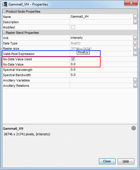
I hope anyone can help with this issue: I am using the Sentinel Toolbox to preprocess Sentinel 1 GRDH scenes. Managed to radiometric calibrate, conduct radiometric terrain flattening and geometric terrain correction in a batch script. Now I want to mosaic these 66 scenes which also basically works. Unfortunately at the left and right borders of the scenes there are very low values (here called 'no dada' values) which I cannot remove. There is a tool called 'S-1 Remove GRD Border Noise'. But applied it does not change anything.
3 Answers
if all of these pixels are of the same value you can edit the no-data value under preferences (right-click the corresponding raster) and save the dataset. The should subsequently no longer be included in the mosaic (red box). If the pixels are of different values you can specify a valid pixel expression to exclude a whole range of values from the mosaic (blue box).
I tried it myself and it seems to work.
-
Thanks a lot AndyB! I checked this option but unfortunately these values are very low (not one single value) and you can find those very low values also within the valid scene. So to exclude this image boundary I would in a way also change the scene itself. Also I'm looking for a tool which I can automate as I will need to apply it to 124 scenes.– estherCommented Jan 18, 2016 at 8:11
I found that the S-1 Remove GRD Border Noise tool in SNAP 2.0.2 worked, when applied as the first processing step to a Sentinel 1A GRD archive. That is, it removed most of the black strip on the scene I tested. It presumably used some kind of thresholding algorithm, because it left behind a very narrow black strip where the pixel values were not quite as low. (However, a subsequent Radiometric Terrain Flattening step appeared to create a new zero-intensity border padding.)
Thanks benjimin! I tried with that tool and had the same problem. It leaves a narrow stripe which is not acceptable for me in the final mosaic. I have a procedure now. Unfortunately it cannot be batched completely, but at least parts of it are automated:
1) apply orbit file and radiometric calibration (these steps are applied to each tile and can be conducted in batch)
2) S1 slice assembly (this step needs to be applied manually to the tiles within each 'orbit stripe')
3) subset each slice (cut manually 1000 pixels at the left and right of each stripe - this is the work step where the critical values are removed)
4) radiometric terrain flattening, geometric terrain correction, speckle filtering (these steps can be batched again)
5) mosaic

