3

I am using the latest version of QGIS 2.14. I have a raster DEM file. I ran the r.watershed and it created all the raster layers for flow direction, stream, etc.

My next step is to run r.water.outlet to subdivide a basin. In the r.water.outlet input window, more specifically the northing and easting input text box, the built in filter does not allow me to enter numbers past the decimal point.

Example: for a point at -73 35 45.5 E when I tried to enter -73.35455 the most that I can enter is -73. and no numbers past the decimal point. Am I doing something wrong?

5
  • Are you using r.water.outlet from the Processing toolbox? I cannot reproduce the issue so far.
    – underdark
    Commented Mar 6, 2016 at 14:16
  • Not from the processing toolbox, from the dialog box that pop up once you click on the grass list of command.
    – Francis
    Commented Mar 6, 2016 at 20:59
  • Yes it is from the Processing toolbox. Sorry for the wrong statement earlier posted.
    – Francis
    Commented Mar 7, 2016 at 2:35
  • I was able to load the needed rasters to create a mapset in the grass plugin, and run r.watershe, and r.water.outlet. In r.water.outlet through the grass plugin I was able to enter the coordinates with decimals. The program run, although the results is not the best. The issue is running r.water.outlet through the processing toolbox. Thanks for showing me the other option of grass plugin. I will use it more often.
    – Francis
    Commented Mar 7, 2016 at 2:52
  • A side note: -73 35 45.5 != -73.35455. You have to convert DD MM SS to decimal degrees.
    – Micha
    Commented Mar 8, 2016 at 6:53

1 Answer 1

2

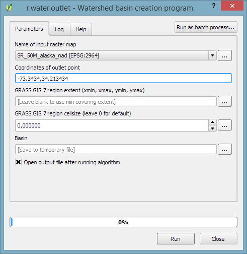
Looks fine here in the Processing toolbox

enter image description here

as well as with the GRASS plugin 2.0 in QGIS 2.14 on Win8

enter image description here

7
  • I have to learn to create the mapset. I got this far to the screen that you show, and was able to enter the coordinate with decimals. However I got some error messages which is basically from my lack of knowledge in using mapset. I was running r.water.outlet not thru the grass plugin but through the processing toolbox. I advise you wrong earlier. It is through the processing tool box dialog box. Sorru for the confusion.
    – Francis
    Commented Mar 7, 2016 at 2:18
  • R.water.oulet loaded from the processing tool box does not allow numbers past the decimal point in the coordinate input text field. Is this a bug?
    – Francis
    Commented Mar 7, 2016 at 23:43
  • The r.water.outlet dialog window from the processing tool box that comes up on my screen is different than the one you showed. The dialog window has two texts entries, one named easting coordinate of outlet point, and one named northing coordinate of outlet point. The one you showed combined the northing and easting.
    – Francis
    Commented Mar 9, 2016 at 1:05
  • Then I suggest that you delete your old processing version
    – underdark
    Commented Mar 9, 2016 at 7:26
  • I reinstalled QGIS, Grass 7, OSGEO4W64, and MSYS64. In the processing toolbox I reconfigured the different plugin. When I opened GRASS GIS 7 commands [148 geoalgorithms] and more specifically r.water.oulet, the window that open is different than the one you showed. My operating system is a Windows 10, and running QGIS on 64 bits. Thanks for your help. I will run r.water.outlet through Grass 7 plugin like you suggested.
    – Francis
    Commented Mar 10, 2016 at 1:48

Your Answer

By clicking “Post Your Answer”, you agree to our terms of service and acknowledge you have read our privacy policy.

Not the answer you're looking for? Browse other questions tagged or ask your own question.