1

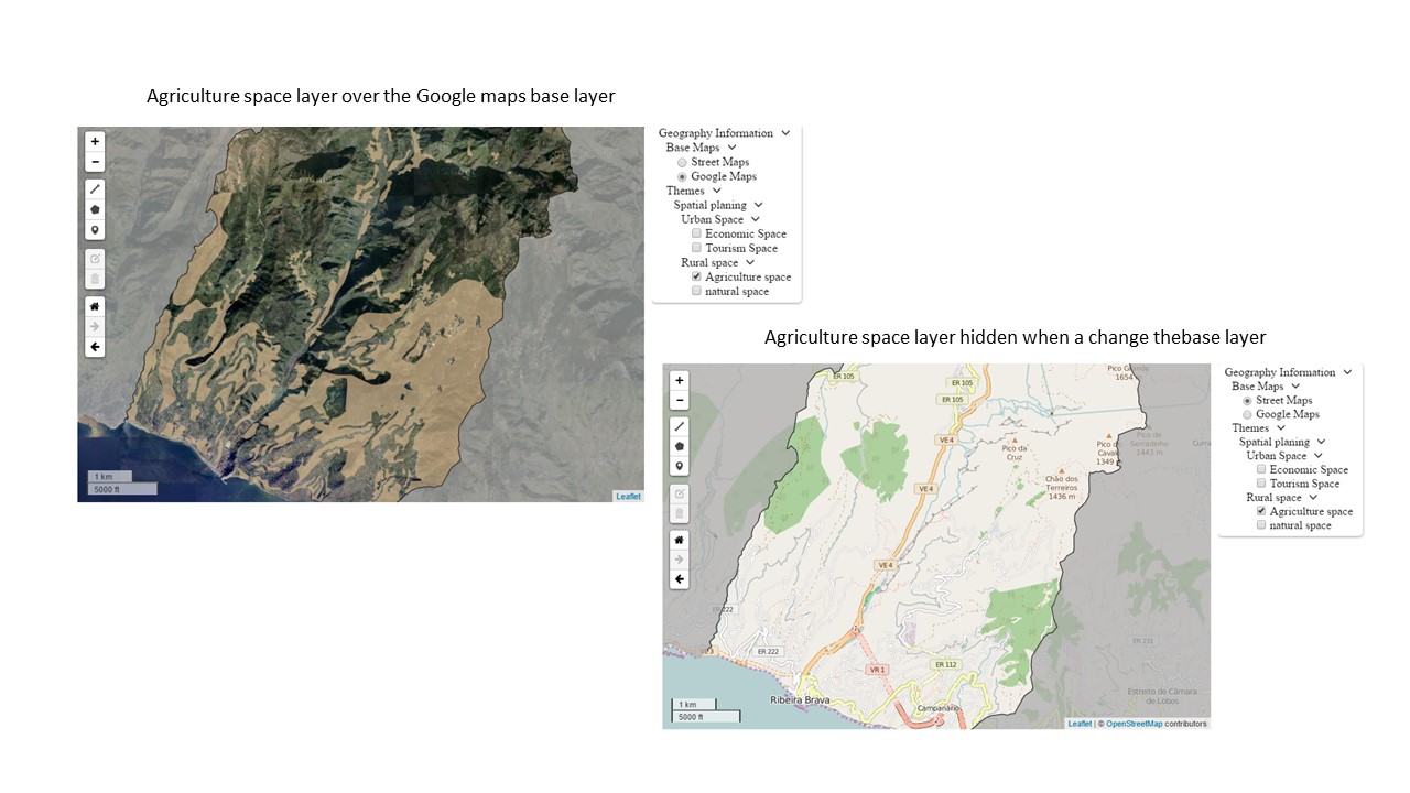
I am creating a leaflet layer tree control with some baselayers and overlays, and I'm having problems with the order of the layers.

When a change a base layer, this overlap the overlays.

This is the part of the code that I use to add the control:

//...
//create the base layers service

var baselayers = {

    GOOGLE1: function(layerSettings) {
        return new L.tileLayer('http://{s}.google.com/vt/lyrs=s&x={x}&y={y}&z={z}', {
            maxZoom: 20,
            minZoom: 12,
            subdomains: ['mt0', 'mt1', 'mt2', 'mt3']
        })
    },
    OSM1: function(layerSettings) {
        return new L.tileLayer(
            'http://{s}.tile.openstreetmap.org/{z}/{x}/{y}.png', {
                maxZoom: 20,
                minZoom: 12,
            })
    }
};


var tree = [

    //Start the root
    {
        "code": "root",
        "name": "Geography Information",
        "active": true,
        "selectedByDefault": false,
        "openByDefault": true,
        "childLayers": [

            //Start the base layers
            {
                "code": "base",
                "name": "Base Maps",
                "active": true,
                "selectedByDefault": true,
                "openByDefault": true,
                "childLayers": [

                    //Start the Open Street Maps
                    {
                        "code": "osm",
                        "name": "Street Maps",
                        "active": true,
                        "selectedByDefault": true,
                        "openByDefault": true,
                        "childLayers": [],
                        "selectType": null,
                        "serviceType": "OSM1",
                        "params": {}
                    },
                    //Finish the Oop Street Maps

                    //Start the Google Maps
                    {
                        "code": "google",
                        "name": "Google Maps",
                        "active": true,
                        "selectedByDefault": false,
                        "openByDefault": true,
                        "childLayers": [],
                        "selectType": "NONE",
                        "serviceType": "GOOGLE1",
                        "params": {}
                    } //Finish the Google Maps
                ],
                "selectType": "SINGLE",
                "serviceType": null,
                "params": {}
            },
            //Finish the base layers

            //Start the Themes group -  Overlays   
            {
                "code": "overlays",
                "name": "Themes",
                "active": true,
                "selectedByDefault": false,
                "openByDefault": true,
                "childLayers": [

                    //Start the Layer Group Spatial planing
                    {
                        "code": "Spatial planing",
                        "name": "Spatial planing",
                        "active": true,
                        "selectedByDefault": true,
                        "openByDefault": true,
                        "childLayers": [

                            //Start the  Urban Space Layer group
                            {
                                "code": "Urban Space",
                                "name": "Urban Space",
                                "active": true,
                                "selectedByDefault": true,
                                "openByDefault": true,
                                "childLayers": [

                                    //Start the layer Economic Space
                                    {
                                        "code": "Economic Space",
                                        "name": "Economic Space",
                                        "active": true,
                                        "selectedByDefault": false,
                                        "openByDefault": null,
                                        "childLayers": [],
                                        "selectType": null,
                                        "serviceType": "WMS",
                                        "params": {
                                            "service": "WMS",
                                            "format": "image/png",
                                            "layers": "rbrava:espaco_de_actividades_economicas",
                                            "url": "http://localhost:8080/geoserver/rbrava/wms",
                                            "transparent": "TRUE"
                                        }
                                    }
                                    // Finish the layer Economic space
                                    ,
                                    //Start the Tourism Space layer 
                                    {
                                        "code": "Tourism Space",
                                        "name": "Tourism Space",
                                        "active": true,
                                        "selectedByDefault": false,
                                        "openByDefault": null,
                                        "childLayers": [],
                                        "selectType": null,
                                        "serviceType": "WMS",
                                        "params": {
                                            "service": "WMS",
                                            "format": "image/png",
                                            "layers": "rbrava:espaco_de_ocupacao_turistica",
                                            "url": "http://localhost:8080/geoserver/rbrava/wms",
                                            "transparent": "TRUE"
                                        }
                                    }
                                    // Finish the  Tourism space layer

                                ],
                                "selectType": "MULTIPLE",
                                "serviceType": null,
                                "params": {}
                            },
                            //Finish the  Urban Space Layer group

                            //Start the Rural Space Layer group
                            {
                                "code": "Rural space",
                                "name": "Rural space",
                                "active": true,
                                "selectedByDefault": true,
                                "openByDefault": true,
                                "childLayers": [

                                    //Start the Agriculture space layer
                                    {
                                        "code": "Agriculture space",
                                        "name": "Agriculture space",
                                        "active": true,
                                        "selectedByDefault": false,
                                        "openByDefault": null,
                                        "childLayers": [],
                                        "selectType": null,
                                        "serviceType": "WMS",
                                        "params": {
                                            "service": "WMS",
                                            "format": "image/png",
                                            "layers": "rbrava:espaco_agricola",
                                            "url": "http://localhost:8080/geoserver/rbrava/wms",
                                            "transparent": "TRUE"
                                        }
                                    },
                                    //Finish the Agriculture space layer 

                                    //Start the Natural space layer
                                    {
                                        "code": "natural space",
                                        "name": "Natural space",
                                        "active": true,
                                        "selectedByDefault": false,
                                        "openByDefault": null,
                                        "childLayers": [],
                                        "selectType": null,
                                        "serviceType": "WMS",
                                        "params": {
                                            "service": "WMS",
                                            "format": "image/png",
                                            "layers": "rbrava:espaco_natural",
                                            "url": "http://localhost:8080/geoserver/rbrava/wms",
                                            "transparent": "TRUE"
                                        }
                                    }
                                    //Finish the Natural space layer

                                ],
                                "selectType": "MULTIPLE",
                                "serviceType": null,
                                "params": {}
                            }
                            //finish the Rural space layer group
                        ],
                        "selectType": "NONE",
                        "serviceType": null,
                        "params": {}
                    }, //finish the  Spatial planning layer group

                ],

                "selectType": "NONE",
                "serviceType": null,
                "params": {}
            }
            //finish Themes group - Overlays
        ],

        "selectType": "NONE",
        "serviceType": null,
        "params": {}
    }
    //finish ROOT

];

// create the control

var control_layers = new L.Control.LayerTreeControl({
    layerTree: tree,
    openByDefault: true,
    layerBuilders: baselayers
}).addTo(map);
//...

and this is the output: enter image description here

0

1 Answer 1

1

Since your layers are of Tile Layer type (this includes when you specify "WMS" for "serviceType"), you should be able to specify the z-index ("stacking order") through the zIndex option.

This should work by simply adding a line similar to zIndex: 0 (adjust the integer) in your layer params options.

0

Your Answer

By clicking “Post Your Answer”, you agree to our terms of service and acknowledge you have read our privacy policy.

Not the answer you're looking for? Browse other questions tagged or ask your own question.