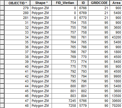
I have a map with about 63 grids and trying to determine the land cover user category of the greatest area size in each grid. The land cover categories have been converted to polygons and I already have attribute tables with a field for "Area" in each grid. I need to create a layer that will give me which land use category has the greatest area size. So I need to sum up the "area" of each category and then determine the max (highest area) and then make a layer for only that category.
i.e. Grid 1 contains - water = 900m, development = 1000m, forest = 2000m Grid 1 - category with highest area size = forest at 2000m - I would need just one layer displaying forest only in that grid. But then do this quickly for all other grids in my map.
I am a mid-level user in ArcMap with decent SQL query skills, so I feel most comfortable in SQL and I'm certain a making a query with a join statement that joins onto itself can get that done for me. I'm looking where/how best to run a SQL query that will be a little more complex than the regular "select * from". Looking at tools like the "Select attribute by" is nice but the SQL query section in there doesn't really allow for inner join statements to be performed. Or if all this needs to be done a different way how I go about to create the layers I need. I could of course trudge through each grid and do it manually but I am looking to learn how to do such things in a faster method and use in the future.
Will I be venturing into ArcPy and/or ModelBuilder?
I want to sum up "Area" per "Gridcode" then determine which "Gridcode" has the highest sum area. Then make that into a new layer. I would not need any other gridcodes if they do not sum up as the max.

