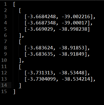
I am struggling with the AntPath Plugin ( link to GitHub ) for Leaflet and the documentation is limited and difficult to read. This setup works well(se code-snippet in the end), but instead I want to add multipolylines. To do that I must change it to:L.MultiPolyline.MultiAntPath(path) and modify JSON-file to my array of polylines.
The valid and working JSON-file for current polyline looks like this:
[[-3.748494, -38.460304],[-3.74845, -38.4603],[-3.7482748, -38.46086]]
But I want something like this(Example for 2 paths):
[[55.778659,12.151137 ], [55.779807,12.158085 ], [55.773663,12.163626 ], [55.769615,12.16311 ]], [[55.766945,12.158487 ], [55.767806,12.154152 ], [55.769787,12.150391 ], [55.772687,12.147922 ]]
How does the setup look like when adding multiple polylines with lat/lon in my new JSON-file (see 2 paths-example)?
$http.get('newsingle.json').then(function (res) {
path = res.data;
L.tileLayer('http://{s}.tile.osm.org/{z}/{x}/{y}.png', {
attribution: '© <a href="http://osm.org/copyright">OpenStreetMap</a> contributors'
}).addTo(map);
layer = new L.Polyline.AntPath(path);
map.addLayer(layer);
map.fitBounds(layer.getBounds());
});
scope.$watch('options', function (opts) {
if (layer !== null) {
map.removeLayer(layer);
layer = new L.Polyline.AntPath(path, opts);
map.addLayer(layer);
}

